Currimundi, Queensland facts for kids
Quick facts for kids CurrimundiCaloundra, Queensland |
|||||||||||||||
|---|---|---|---|---|---|---|---|---|---|---|---|---|---|---|---|

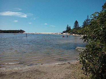
Lake Currimundi and beach, 2016
|
|||||||||||||||
| Population | 6,570 (2021 census) | ||||||||||||||
| • Density | 1,825/km2 (4,730/sq mi) | ||||||||||||||
| Postcode(s) | 4551 | ||||||||||||||
| Area | 3.6 km2 (1.4 sq mi) | ||||||||||||||
| Time zone | AEST (UTC+10:00) | ||||||||||||||
| Location |
|
||||||||||||||
| LGA(s) | Sunshine Coast Region | ||||||||||||||
| County | Canning | ||||||||||||||
| Parish | Bribie | ||||||||||||||
| State electorate(s) | Kawana | ||||||||||||||
| Federal Division(s) | Fisher | ||||||||||||||
|
|||||||||||||||
Currimundi is a beautiful coastal suburb located in Caloundra. It is part of the Sunshine Coast Region in Queensland, Australia. In 2021, about 6,570 people lived in Currimundi.
This area is famous for its amazing natural environment. It is even one of Queensland's top five places for ecotourism. This means it's a great spot for enjoying nature responsibly.
Contents
Exploring Currimundi's Geography
Currimundi is found on the northern edge of the Caloundra area. It has a special saltwater lake called Currimundi Lake. This lake sits right next to Currimundi Beach.
Currimundi Lake and Beach
North of the lake, you'll find the Currimundi Lake (Kathleen McArthur) Conservation Park. This park is a protected area for nature. A main road called Nicklin Way crosses over Currimundi Lake. It uses the Ahern Bridge. This bridge was named after John Ahern, a brave firefighter.
Currimundi Beach is very popular, especially during holidays. Surf Life Saving Australia lifeguards keep the beach safe. They patrol on weekends and during school holidays.
Local Shopping
If you need to go shopping, Currimundi has its own shopping centre. It is known as the Currimundi Markets.
A Glimpse into Currimundi's History
Before European settlers arrived, Currimundi was the traditional home of the Kabi Kabi people. They are the original Aboriginal people of this land.
How Currimundi Got Its Name
The name "Currimundi" was given by Sir Leslie Wilson. He was the Governor of Queensland. He used a local Aboriginal name for the area. This name was Garamandah or Girramundi. It means "place of flying foxes."
Currimundi During World War II
During World War II, Currimundi Lake and the nearby beach areas were used for defence. Soldiers practiced artillery here to prepare for the war.
Who Lives in Currimundi?
The number of people living in Currimundi changes over time.
- In 2016, the population was 6,786 people.
- By 2021, the population was 6,570 people.
Learning in Currimundi
Currimundi has several schools for young learners.
Primary Schools
- Currimundi State School opened on January 24, 1977. It is a government primary school for students from Prep to Year 6. In 2018, it had 579 students. The school also has a special education program. You can find it at 17 Buderim Street.
- Talara Primary College opened on January 22, 1998. This is another government primary school. It teaches students from Early Childhood to Year 6. In 2018, it had 1,132 students. Talara Primary College also offers a special education program. It is located on Talara Street.
Secondary Schools
For older students, the closest government secondary schools are:
- Caloundra State High School
- Kawana Waters State College
- Meridan State College
Currimundi's Amazing Environment
Currimundi is well-known for its beautiful natural areas. It is home to the Currimundi Lake (Kathleen McArthur) Conservation Park. This park is a popular spot for bushwalks and exploring nature.
Rich Biodiversity
The area has many different types of plants and animals. This is called high biodiversity. You can find coastal heath, open forests, woodlands, and even small rainforests. There are also unique plant communities like sedgeland and casuarina dunes.
Protecting the Waterways
The Sunshine Coast Region Council sees Currimundi Lake as a very important natural place. It is important for both people and local wildlife. Because of this, they regularly work to protect the waterways. They also manage erosion to keep the area healthy.
Two local community groups help with this effort:
- Currimundi Catchment Care Group Inc
- Friends of Currimundi Lake
These groups work with the Sunshine Coast Council. Their goal is to improve the Currimundi Catchment and care for the environment.
Awards and Recognition
In 2004, Currimundi won the "Queensland's Cleanest Beach" award. This shows how much care goes into keeping the area clean.
In 2023, Currimundi Lake was named one of Queensland's top five 'ecotourism' spots. It became much more popular after the COVID-19 Pandemic. Visitor numbers increased by 325%!
Currimundi in Books
Currimundi Lake is featured in a children's book. It is called The Oobleegooblers of Lake Curramundi. Kath Dewhurst wrote this book in 1977. The story is based on a local Aboriginal tale.
 | James Van Der Zee |
 | Alma Thomas |
 | Ellis Wilson |
 | Margaret Taylor-Burroughs |


