Darke Peak facts for kids
Quick facts for kids Darke PeakSouth Australia |
|||||||||||||||
|---|---|---|---|---|---|---|---|---|---|---|---|---|---|---|---|
| Established | 4 June 1914 (town) 23 December 1998 (locality) |
||||||||||||||
| Postcode(s) | 5633 | ||||||||||||||
| Elevation | 247 m (810 ft) | ||||||||||||||
| Time zone | ACST (UTC+9:30) | ||||||||||||||
| • Summer (DST) | ACST (UTC+10:30) | ||||||||||||||
| Location |
|
||||||||||||||
| LGA(s) | District Council of Cleve | ||||||||||||||
| Region | Eyre Western | ||||||||||||||
| County | Jervois | ||||||||||||||
| State electorate(s) | Flinders | ||||||||||||||
| Federal Division(s) | Grey | ||||||||||||||
|
|||||||||||||||
|
|||||||||||||||
| Footnotes | Adjoining localities | ||||||||||||||
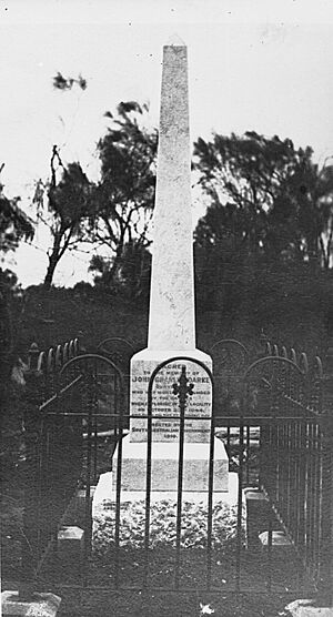
Darke Peak (formerly Carappee) is a small agricultural town in central Eyre Peninsula, South Australia. It is the main community for the farms around it. The town has also become a minor historical place for visitors. It is located on the traditional lands of the Barngarla people. The J. C. Darke Memorial and Grave, which remembers early European explorer John Charles Darke, is near the town. This memorial is listed on the South Australian Heritage Register.
The town has a few services. These include places to stay, grocery stores, and fuel supplies.
Contents
History of Darke Peak
The land around Darke Peak was historically home to the Nauo and Barngarla Indigenous groups.
The town is named after the explorer John Charles Darke. He died near Waddikee Rock on October 25, 1844. This rock is a sacred site for the Barngarla people. The Governor at the time, Governor Grey, wanted a landform in the area to be named after Darke. In 1865, a surveyor named Thomas Evans measured the area. He named a 1,564 ft (477 m) high mount 'Darke's Peak'.
In 1909, another surveyor, W.G. Evans, found bones in a grave. He believed they were the remains of Darke. Darke's grave and a monument are on the western side of the range. They stand as a memorial to the first European who explored this area. The SA Government put up the memorial in 1910.
The town of Darke Peak was first called Carappee in 1914. It was renamed Darke Peak in 1940. This was to further honor John Charles Darke. A school opened in the town in 1917.
Darke Peak includes the Darke Range and Caralue Bluff. It also has the Carappee Hill Conservation Park and Carappee Hill nearby. Carappee Hill is known for being the highest exposed granite rock mass on the Eyre Peninsula.
What Darke Peak's Economy Is Like
Darke Peak is mainly a farming community. The areas around it grow cereal crops like wheat. Farmers also raise sheep. This helps them when there isn't much rainfall. Local farmers have been working the land for many generations. They were farming even before the town was officially started. The farming here is much like other towns in central Eyre Peninsula. They grow similar crops in similar climate conditions.
Tourism is a smaller part of the town's economy. Darke's Grave, the Darke Range, and various tourist drives are the main attractions. You can find tourist information at The Peak Stop shelter.
Facilities in Darke Peak
Darke Peak has a hotel that has been there since the early days of the town. It offers places to stay and meals.
The town also has sporting facilities. These include tennis and netball courts, an oval, a playground, a swimming pool, and a golf course. Some local sports teams compete in leagues.
How Darke Peak Is Governed
Darke Peak is part of the local government area called the District Council of Cleve. For state elections, it is in the Electoral district of Flinders. For federal elections, it is in the Division of Grey.


