Dead Indian Pass facts for kids
Quick facts for kids Dead Indian Pass |
|
|---|---|

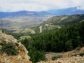
The view from the top of Dead Indian Pass on the Chief Joseph Scenic Byway
|
|
| Elevation | 8,071 ft (2,460 m) |
| Traversed by | Wyoming Highway 296 |
| Location | Park County, Wyoming, United States |
| Range | Rocky Mountains |
| Coordinates | 44°44′37″N 109°23′06″W / 44.74361°N 109.38500°W |
| Topo map | USGS Dead Indian Meadows |
Dead Indian Pass is a mountain pass in Wyoming, United States. It is about 8,071 feet (2,460 meters) high. The pass is part of Wyoming Highway 296, which is also known as the Chief Joseph Scenic Byway. It crosses the Absaroka Range of the Rocky Mountains.
A stream called Dead Indian Creek flows near the pass. There are also other places nearby with similar names, such as Dead Indian Gulch and Dead Indian Mountain.
Contents
The Nez Perce Journey Through Dead Indian Pass
Dead Indian Pass is famous because of an important event during the Nez Perce War in 1877. This war involved the Nez Perce people and the United States Army.
Chief Joseph's Clever Plan
In 1877, the Nez Perce people were on a long journey. They were trying to escape from the U.S. Army. Their leader was Chief Joseph. About 700 Nez Perce people, including men, women, and children, traveled with 2,000 horses.
They had traveled through Yellowstone National Park. Then they moved eastward into the Absaroka Mountains. The Nez Perce hoped to find a way out of the mountains and onto the wide-open Great Plains.
However, the U.S. Army knew the Nez Perce might try to reach the Plains. General Samuel D. Sturgis and 600 soldiers were waiting for them. Sturgis's troops were placed where they could quickly move to block trails along the Clarks Fork or the Shoshone River.
General Sturgis thought the Clark's Fork area was too difficult for anyone to pass through. The lower part of the Clark's Fork River flows through a very narrow canyon with tall, steep walls.
Outsmarting the Army
On September 8, 1877, the Nez Perce reached Dead Indian Pass. They were about six miles from where General Sturgis's soldiers were waiting below. The Nez Perce scouts saw the soldiers. If they took the easy, open route to the Plains, the army would see them right away.
So, the Nez Perce came up with a clever plan to trick the soldiers.
- First, they pretended to go south toward the Shoshone River. They rode their horses in a big circle. This kicked up a lot of dust, making it look like they were heading that way.
- Then, hidden by thick trees, they quietly moved north. They went down Dead Indian Gulch to the Clark's Fork River.
Dead Indian Gulch was a very narrow and steep crack in the rocks. It dropped almost straight down for 1,000 feet (about 300 meters). It was barely wide enough for two horses to walk side-by-side.
This was a very smart move by the Nez Perce. They avoided a dangerous situation and gained some time.
The Army's Mistake
General Sturgis fell for the trick. He moved his soldiers away from the Clark's Fork and headed south toward the Shoshone River. Because of this, the Nez Perce were able to reach the Great Plains without any fighting.
Sturgis soon realized his mistake and turned back. On September 11, he met up with General Oliver Otis Howard, who had been following the Nez Perce's original path. But by then, the Nez Perce were two days and 50 miles (about 80 kilometers) ahead of the army. The U.S. Army finally caught up with and defeated the Nez Perce almost a month later at the Battle of Bear Paw.
Why is it Called Dead Indian Pass?
There are two main stories about how Dead Indian Pass got its name.
- The first story is connected to the Nez Perce journey in 1877. It is said that a Nez Perce person was killed near the pass. This event then gave the pass its name.
- The second story is from 1878. It says that Colonel Nelson A. Miles and his soldiers met a group of Bannock Indians. Crow scouts working with the U.S. Army killed a Bannock person and buried them there.
Images for kids
 | Claudette Colvin |
 | Myrlie Evers-Williams |
 | Alberta Odell Jones |


