Department of Junín facts for kids
Quick facts for kids
Department of Junín
|
|||
|---|---|---|---|
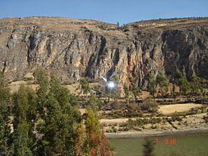
Partial view of Lake Junin
|
|||
|
|||
Location of the Junín Region in Peru
|
|||
| Country | Peru | ||
| Subdivisions | 9 provinces and 123 districts | ||
| Capital | Huancayo | ||
| Area | |||
| • Total | 44,197.23 km2 (17,064.65 sq mi) | ||
| Highest elevation | 4,818 m (15,807 ft) | ||
| Population
(2017)
|
|||
| • Total | 1,246,038 | ||
| • Density | 28.192672/km2 (73.01868/sq mi) | ||
| UBIGEO |
12
|
||
| Dialing code | 064 | ||
| ISO 3166 code | PE-JUN | ||
| Principal resources | Potato, coffee, fruit, silver, zinc, lead. | ||
| Website | www.regionjunin.gob.pe | ||
Junín is a region in the central Peruvian highlands. It also reaches into the western part of the Peruvian Amazon. Its capital city is Huancayo. This region is known for its amazing landscapes and rich history.
Contents
Exploring Junín's Geography
The Junín region has many different types of land. In the west, near the Lima Region, you can find tall mountains with snow and ice. These are part of the cordillera, which is a long chain of mountains.
Further east, there are high valleys formed by glaciers. These valleys lead to large, flat areas called plateaus. One famous plateau is the Junín Plateau, located between the cities of La Oroya and Cerro de Pasco.
The Mantaro Valley is a wide area that holds many of the region's people. It stretches from Jauja to the border of the Huancavelica Region. Towards the eastern side, closer to the jungle, you'll see narrow, deep canyons. These canyons have very steep sides covered in forests, often hidden by low clouds.
The Waytapallana mountain range is in the south-central part of Junín. This range has a big crack in the Earth's crust, called a fault. This fault is why earthquakes sometimes happen in the area. The upper jungle part of the region has long valleys. These valleys were shaped by rivers like the Tulumayu, Pawqartampu, Perené, and Ene.
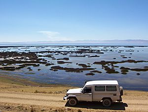
Lake Junin is the biggest lake completely inside Peru. Most of it is in the Junín region. Only its very northern tip is in the Pasco Region. Junín Region is also home to Mount Toromocho.
Junín's Borders: What's Around It?
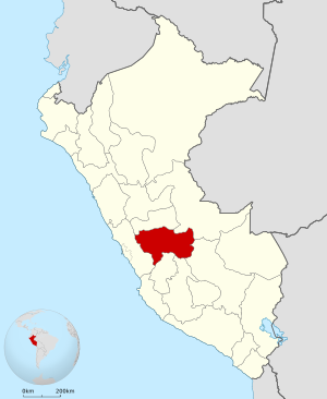
The Junín Region shares its borders with several other regions. To the north, it meets the Pasco Region. To the northeast, it borders the Ucayali Region. The Cusco Region is to its east.
The Mantaro River forms the southern border with the Ayacucho Region and Huancavelica Region. To the west, Junín is next to the Lima Region.
Junín's Weather: What's the Climate Like?
The Junín Region has an average temperature of about 13.1°C (56°F) each year. The highest temperature can reach around 17°C (62°F), and the lowest can drop to 0°C (32°F).
The rainy season in Junín usually runs from November to April. In the warmer, tropical areas, the rainiest months are from December to March.
How Junín is Organized: Political Divisions
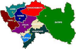
The Junín region is divided into nine main areas called provinces. Each province has its own main city, called a seat. These provinces are then split into smaller areas called districts. There are 123 districts in total!
| Province | Seat | |
|---|---|---|
| Chanchamayo | Chanchamayo | |
| Chupaca | Chupaca | |
| Concepción | Concepción | |
| Huancayo | Huancayo | |
| Jauja | Jauja | |
| Junín | Junín | |
| Satipo | Satipo | |
| Tarma | Tarma | |
| Yauli | La Oroya |
People and Languages in Junín
Most people in Junín speak Spanish. This is the first language for about 86.63% of the residents. The second most common language is Quechua, spoken by about 9.29% of the people.
Different types of Quechua are spoken here. For example, Huanca Quechua is heard in the southwest. Yaru Quechua is spoken in the northwest, especially in Tarma Province. Other native languages, like Asháninka, are also spoken in some areas.
A Look Back: Junín's History
Before the Incas arrived, the eastern plains of Junín were home to the Yanesha' and Asháninka people. They lived by hunting and gathering food. They were often unfriendly to outsiders. Meanwhile, the Huancas lived in the Mantaro Valley to the southwest.
In 1460, the great Inca ruler Pachacuti took control of this region. This made Junín part of the powerful Inca Empire. The city of Huancayo became an important stop along the famous Inca Trail.
During the time when Peru was a Spanish colony, special mills were built. These mills, called "obrajes," made woven fabrics. This tradition of weaving and crafting textiles continues in Junín even today.
On September 13, 1825, a special order was made by Simón Bolívar. This order created what we now know as the Junín Region. It was named to remember his victory in the Battle of Junín. This battle was unique because it was a cavalry charge where no shots were fired.
Later, important events for Peru happened here. In 1839, Huancayo hosted a meeting that created a new constitution for the country. Also, on December 3, 1854, Ramón Castilla signed a paper that gave freedom to Afro-Peruvian slaves.
Cool Places to Visit in Junín
- Asháninka Communal Reserve
- Chacamarca Historical Sanctuary
- Convent of Santa Rosa de Ocopa
- Gran Pajonal
- Nor Yauyos-Cochas Landscape Reserve
- Otishi National Park
- Pampa Hermosa Reserved Zone
See also
 In Spanish: Departamento de Junín para niños
 | Selma Burke |
 | Pauline Powell Burns |
 | Frederick J. Brown |
 | Robert Blackburn |


