Desventuradas Islands facts for kids
|
Native name:
Islas Desventuradas
|
|
|---|---|

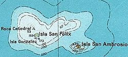
Map of Desventuradas Islands, also known as San Félix Islands
|
|
| Geography | |
| Location | Chilean Sea |
| Coordinates | 26°19′S 80°00′W / 26.32°S 80°W |
| Archipelago | Desventuradas |
| Adjacent bodies of water | Pacific Ocean |
| Total islands | 4 |
| Major islands | San Ambrosio, San Félix, Gonzalez and Roca Catedral |
| Area | 5.36 km2 (2.07 sq mi)(together) |
| Highest elevation | 479 m (1,572 ft) max. |
| Administration | |
| Region | |
| Province | Valparaíso Province |
| Commune | Juan Fernández |
| Demographics | |
| Population | 11 |
| Additional information | |
| Time zone | |
| • Summer (DST) | |
| NGA UFI= -900077 "San Ambrosio" -883263 "Gonzáles" -900282 "San Félix" |
|
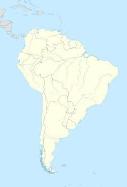
The Desventuradas Islands (which means "Unfortunate Islands" in Spanish) are a group of four small islands. They are located about 850 kilometers (528 miles) off the coast of Chile in the Pacific Ocean. These islands are part of what is known as Insular Chile, which includes islands far from the mainland.
Because they are so isolated and hard to reach, no regular people live on these islands. However, a small group of the Chilean Navy is stationed on Isla San Félix. This island also has an airport that is 2,000 meters (6,560 feet) long.
Contents
A Look Back in Time
No Ancient People Found
Scientists have not found any signs that ancient people, like Polynesians or Native Americans, ever lived on the Desventuradas Islands. They also didn't find any signs on the nearby Juan Fernández Islands. It seems these islands were empty before Europeans arrived.
Who Discovered Them?
It's possible that Ferdinand Magellan saw these islands as early as 1521. However, the first confirmed sighting was by Juan Fernández. He saw them on November 6, 1574, while sailing from Callao to Valparaíso.
In 1579, Pedro Sarmiento de Gamboa wrote that the islands were named after Saint Felix and Saint Ambor. Over time, the name Ambor got mixed up with the more famous bishop Saint Ambrose (San Ambrosio).
A Role in the Falklands War
San Félix Island played a small part in the Falklands War in May 1982. The Chilean government allowed a British Nimrod R1 plane to fly from the island. This plane helped gather information about the movements of the Argentine Air Force.
Nature and Wildlife
Island Plants and Trees
The larger islands have a mix of different plants. You can find small bushes, bare rocks, various sizes of trees, and shrubs. There are also ferns and other plants that grow all year. Sonchus laceratus is a special type of shrub that only grows here.
The two largest islands, San Félix and San Ambrosio, are home to a special kind of temperate forest. This forest is recognized by the WWF.
Ocean Life
The marine animals around these islands are more like those found in the central and south Pacific Ocean. They are less like the animals found near South America. This is partly because of the Humboldt Current. This strong ocean current creates a natural barrier between these islands and South America.
Birds and Water
There are no permanent sources of fresh water on any of the islands. This means that only birds live there permanently. Ten types of marine birds and one type of land bird use the islands for nesting or visit them. Some of these birds are endangered.
The island group is known as an Important Bird Area (IBA) by BirdLife International. This is because many Masatierra petrels breed here.
Islands and Their Locations
The Desventuradas Islands are listed from east to west:
| Island/Rock | Area (km²) |
Peak Elevation (m) |
Geographical Coordinates |
|||||
|---|---|---|---|---|---|---|---|---|
| San Ambrosio | 3.1 | 479 | 26°20′37″S 79°53′28″W / 26.34361°S 79.89111°W | |||||
| San Felix group | ||||||||
| Islote González | 0.25 | 173 | 26°18′36″S 80°05′06″W / 26.31000°S 80.08500°W | |||||
| San Félix | 2 | Cerro Amarillo, 193 | 26°17′30″S 80°05′42″W / 26.29167°S 80.09500°W | |||||
| Roca Catedral | 0.01 | 53 | 26°16′25″S 80°07′15″W / 26.27361°S 80.12083°W | |||||
| Total | 5.36 | 479 | ||||||
See also
 In Spanish: Islas Desventuradas para niños
- List of islands of Chile
- Insular Chile
 | Sharif Bey |
 | Hale Woodruff |
 | Richmond Barthé |
 | Purvis Young |


