
Dharmapuri facts for kids
Quick facts for kids
Dharmapuri
Thagadur
|
|
|---|---|

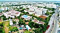
Aerial view of mid-city
|
|
| Nickname(s):
Thagadoor, Dharmapuri
|
|

Dharmapuri
Location in Tamil Nadu

Dharmapuri
Location in India
|
|
| Country | |
| State | |
| District | Dharmapuri |
| Established | 10th Century BC |
| Founded by | The King Adhiyaman |
| Government | |
| • Type | Special Grade Municipality |
| • Body | Dharmapuri Municipality |
| Area | |
| • Total | 25.32 km2 (9.78 sq mi) |
| Area rank | 9 |
| Elevation | 482 m (1,581 ft) |
| Population
(2017)
|
|
| • Total | 113,218 |
| • Density | 4,471.5/km2 (11,581.1/sq mi) |
| Languages | |
| • Official | Tamil |
| Time zone | UTC+5:30 (IST) |
| PIN |
636(7xx),636(8xx)
|
| Telephone code | 4342 |
| Vehicle registration | TN-29 |
| Website | www.dharmapuri.nic.in |
Dharmapuri is a city in the northwestern part of Tamil Nadu, India. It is the main city of the Dharmapuri district. This district was the first one created in Tamil Nadu after India became independent. It was formed on October 2, 1965, by splitting from the old Salem district.
Dharmapuri is known for growing and producing many mangoes. It is often called the Mango Capital of India. The city is located about 126 km from Bangalore and 300 km from Chennai, the capital of Tamil Nadu.
Contents
Exploring Dharmapuri's Past
Dharmapuri was once known as Thagadoor. A powerful king named Adhiyamaan ruled here. Many temples were built during his time. There is even a legend about a secret tunnel connecting two temples.
Ancient Dynasties and Rulers
Over many centuries, different powerful groups ruled this area.
- In the 8th century, the Pallavas likely controlled the region.
- The Rashtrakutas took over in the 9th century.
- Later, in the 11th century, the Cholas defeated the Rashtrakutas. This brought Dharmapuri under Chola rule.
British Rule and District Formation
In the 18th century, the Dharmapuri area was part of the Kingdom of Mysore. It was called Baramahal back then. After a war, Tipu Sultan gave this land to the British East India Company in 1792. It then became part of the Madras Presidency, a large area controlled by the British in India.
Dharmapuri remained part of the Salem District under British rule. The separate Dharmapuri district was officially formed on October 2, 1965. In 2004, the Dharmapuri district was further divided into two: Dharmapuri and Krishnagiri districts.
Discovering Old Relics
Many old rock carvings and sculptures have been found in this district. For example, the village of Modhur has remains from the Stone Age. A government museum in Dharmapuri city displays some of these important historical items.
Where is Dharmapuri Located?
Dharmapuri is in the northwestern part of Tamil Nadu. It is surrounded by hills called the Eastern Ghats to the east. The city is about 300 km from Chennai and 130 km from Bangalore. Many other major cities in Tamil Nadu are within 300 km of Dharmapuri. Important cities from nearby states like Bangalore and Mysore are also close by. This makes Dharmapuri a key location in South India.
Dharmapuri's Weather and Climate
Dharmapuri has a tropical wet and dry climate. This means it has hot, dry summers and warm winters.
Temperature and Rainfall
- The summer months (March to June) are very hot and dry. Temperatures can reach up to 38 °C (100 °F).
- In December and January, the temperatures drop. The coolest month is January, with lows around 14 °C (57 °F).
- The district gets about 910 mm (36 inches) of rain each year on average.
- The forests here usually have short shrubs and thorny plants.
| Climate data for Dharmapuri (1981–2010, extremes 1975–2012) | |||||||||||||
|---|---|---|---|---|---|---|---|---|---|---|---|---|---|
| Month | Jan | Feb | Mar | Apr | May | Jun | Jul | Aug | Sep | Oct | Nov | Dec | Year |
| Record high °C (°F) | 34.2 (93.6) |
37.8 (100.0) |
40.0 (104.0) |
41.0 (105.8) |
41.4 (106.5) |
40.0 (104.0) |
41.0 (105.8) |
38.0 (100.4) |
37.6 (99.7) |
35.0 (95.0) |
33.7 (92.7) |
33.8 (92.8) |
41.4 (106.5) |
| Mean daily maximum °C (°F) | 29.5 (85.1) |
32.7 (90.9) |
35.6 (96.1) |
37.0 (98.6) |
36.6 (97.9) |
34.2 (93.6) |
33.3 (91.9) |
32.6 (90.7) |
32.4 (90.3) |
30.8 (87.4) |
29.0 (84.2) |
28.0 (82.4) |
32.6 (90.7) |
| Mean daily minimum °C (°F) | 17.7 (63.9) |
18.7 (65.7) |
20.8 (69.4) |
23.8 (74.8) |
24.4 (75.9) |
23.8 (74.8) |
23.4 (74.1) |
23.0 (73.4) |
22.6 (72.7) |
21.8 (71.2) |
20.1 (68.2) |
18.3 (64.9) |
21.5 (70.7) |
| Record low °C (°F) | 10.6 (51.1) |
11.0 (51.8) |
14.2 (57.6) |
17.0 (62.6) |
18.2 (64.8) |
20.0 (68.0) |
18.9 (66.0) |
15.5 (59.9) |
17.7 (63.9) |
12.9 (55.2) |
13.0 (55.4) |
10.9 (51.6) |
10.6 (51.1) |
| Average rainfall mm (inches) | 5.0 (0.20) |
3.8 (0.15) |
22.5 (0.89) |
44.2 (1.74) |
96.7 (3.81) |
70.0 (2.76) |
75.6 (2.98) |
105.5 (4.15) |
170.5 (6.71) |
181.5 (7.15) |
93.8 (3.69) |
41.5 (1.63) |
910.6 (35.86) |
| Average rainy days | 0.5 | 0.3 | 1.3 | 2.5 | 6.0 | 3.8 | 4.8 | 6.0 | 8.0 | 9.3 | 5.9 | 2.8 | 51.2 |
| Average relative humidity (%) (at 17:30 IST) | 50 | 39 | 32 | 38 | 46 | 51 | 54 | 55 | 60 | 68 | 67 | 60 | 52 |
| Source: India Meteorological Department | |||||||||||||
People of Dharmapuri
| Religious census | ||||
|---|---|---|---|---|
| Religion | Percent(%) | |||
| Hindu | 88.99% | |||
| Muslim | 9.65% | |||
| Christian | 0.99% | |||
| Sikh | 0.02% | |||
| Buddhist | 0.01% | |||
| Jain | 0.01% | |||
| Other | 0.33% | |||
In 2011, Dharmapuri had a population of about 113,218 people. There were slightly more females than males. About 6,759 children were under the age of six.
Most people in Dharmapuri are Hindus (around 89%). There is also a significant number of Muslims (about 9.6%) and Christians (around 1%). The average literacy rate in the town was 77.08%, which is higher than the national average for India.
Getting Around Dharmapuri
Dharmapuri has good connections for travel by road, rail, and air.
Road Travel
- National Highways: The city is connected by major national highways. NH-44, which runs from north to south across India, passes through Dharmapuri. Another highway, NH-844, starts in Dharmapuri and goes towards Bangalore.
- State Highways: Several state highways also pass through the city. These include SH-60 (connecting Hogenakkal, Pennagaram, Dharmapuri, and Tirupattur) and SH-60A (connecting Dharmapuri and Harur). Some sections of these roads are being made wider to allow for easier travel to cities like Puducherry and Villupuram.
Train Travel
- Dharmapuri Railway Station: The main train station, Dharmapuri railway station (DPJ), is about 1.6 km from the bus stand. It is part of the Bangalore railway division.
- Train Lines: Currently, one main train line connects Bengaluru, Dharmapuri, and Salem. Another line, the Dharmapuri–Morappur line, is being rebuilt and electrified. This new line will connect Dharmapuri directly to Chennai. It will also be an alternative route between Bangalore and Chennai.
- Other Stations: Morappur (MAP) and Bommidi (BQI) are two other important railway stations nearby. They connect Dharmapuri to major cities like Chennai and Coimbatore through other junctions.
Air Travel
- Nearest Airports: The closest airport is Salem airport, about 45 km away. For international flights, the nearest airport is Kempegowda International Airport in Bengaluru (Bangalore), which is about 155 km from Dharmapuri.
Images for kids
-
Aerial view of mid-city
See also
 In Spanish: Dharmapuri para niños
