
Pondicherry facts for kids
Quick facts for kids
Pondicherry
Pondichéry (French)
|
||
|---|---|---|
|
City
|
||
| Puducherry | ||
|
Promenade Beach
Manakula Vinayagar Temple
Sri Aurobindo Ashram
The Matrimandir in Auroville
Aayi Mandapam monument at Bharati Park
Pondicherry Lighthouse
Basilica of the Sacred Heart of Jesus
French War Memorial built after World War I
Mahamata Gandhi Statue along the Beach Road
|
||
|
||
Nickname(s):
|
||

Pondicherry
Location in Puducherry

Pondicherry
Location in India
|
||
| Country | ||
| Union territory | Puducherry (PY) | |
| District | Puducherry | |
| Established | 1674 | |
| Government | ||
| • Type | Municipal Council | |
| • Body | Pondicherry Municipal Council (PDY) | |
| Area | ||
| • Total | 19.54 km2 (7.54 sq mi) | |
| Elevation | 3 m (10 ft) | |
| Population
(2011)
|
||
| • Total | 244,377 | |
| • Density | 12,506/km2 (32,392/sq mi) | |
| Demonym(s) | Puducherrian, Pondicherrian, Pondian, Pondichérien, Pondichérienne | |
| Languages | ||
| • Official | Tamil, English | |
| • Additional | French | |
| Time zone | UTC+5:30 (IST) | |
| PIN CODE |
605001-605014
|
|
| Telephone code | (International) +91-413-, (National) 0413- | |
| Vehicle registration | PY-01 to PY-05 | |
| Website | https://www.py.gov.in/ | |

.jpg)


Pondicherry (/ˌpɒndɪˈtʃɛri/ PON-dih-CHERR-ee; Tamil: [paːɳɖit͡ːʃeːɾi]; French: Pondichéry IPA: [pɔ̃.di.ʃe.ʁi]), also known as Puducherry, is a vibrant city in India. It is the capital and largest city of the Union Territory of Puducherry. This city sits on the southeast coast of India, next to the Bay of Bengal. It shares much of its culture and language with the state of Tamil Nadu.
Contents
History of Pondicherry
Puducherry was once called Pondicherry. It became known as the "French Riviera of the East" after the French arrived. The name Puducherry means "new town" in Tamil. It comes from "Poduke," a port town for Roman trade long ago. The city was also known as Vedapuri, a place for learned scholars.
Early History and Dynasties
The history of Puducherry has two main parts: before and during colonial rule. The pre-colonial period began with the Pallavas, who ruled from 325 to 900 AD. After them came the Chola dynasty (900 to 1279) and the Pandya dynasty (1279 to 1370).
During the 14th century, the city was part of the Vijayanagara Empire. Later, the Sultan of Bijapur took control from 1614 to 1638. During this time, Portuguese and Danish merchants used Pondicherry as a trading center.
European Trade and French Rule
The colonial period started when the Portuguese began trading textiles in 1521. Later, the Dutch and Danes also came to trade in the 17th century.
The French were attracted by Pondicherry's busy trade. In 1674, Francois Martin, a French pioneer, set up a French settlement. This laid the foundation for the town's unique look.
In 1693, the Dutch captured Puducherry during a war. However, it was given back to the French in 1699 by the Treaty of Ryswick.
The French expanded their control, acquiring Mahé in 1720, Yanam in 1731, and Karaikal in 1738. The British and French fought over the city many times. The British captured it in 1761 but returned it in 1763 after the Treaty of Paris.
The Anglo-French wars continued until 1814. France kept control of Puducherry, Mahé, Yanam, Karaikal, and Chandernagor. This French rule lasted for 138 years.
Transfer to India
On October 31, 1954, the French officially left India. This was a "de facto" (in reality) transfer of power. Nearby areas like Arikamedu and Villianur also became part of the new Union Territory of Pondicherry.

On March 18, 1954, local councils in Pondicherry voted to join India. Councils in Karaikal also voted similarly. Most people wanted to merge with India right away. The Indian government promised to respect their culture and rights.
On October 18, 1954, a general election was held. Out of 178 people, 170 voted for the merger. The French territories officially joined the Indian Union on November 1, 1954. The final treaty, called the "de jure" (by law) transfer, was signed in 1956. However, it took until August 16, 1962, for France to fully agree to it.

Geography and Environment
Pondicherry's land is flat, similar to coastal Tamil Nadu. It is at sea level and has several sea inlets, locally called "backwaters."
Coastal Changes
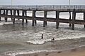
Pondicherry faces serious coastal erosion. This started after a breakwater was built in 1989. Where there used to be a wide, sandy beach, now a 2-km-long seawall protects the city.
The seawall is made of granite boulders. More boulders are added every year to stop erosion. This seawall has caused the seabed to erode and has harmed sea life. It has also caused beaches north of the city to disappear.
Economy and Agriculture

In 2012, the Ministry of Power started a "Smart Grid" project in Puducherry. This helps manage electricity better.
Farming is important around Pondicherry. Farmers grow crops like rice, pulses (beans and lentils), sugarcane, coconuts, and cotton.
Climate and Weather
Pondicherry has a tropical savanna climate, much like other coastal areas in Tamil Nadu.
Seasons in Pondicherry
- Summer: From April to early June, temperatures can reach 41 °C (106 °F). The average high is 36 °C (97 °F).
- Humidity: From June to September, it's very humid with occasional thunderstorms.
- Monsoon: The northeast monsoon brings most of the rain from October to December. The city gets about 1,355 millimetres or 53 inches of rain each year.
- Winter: Winters are warm, with highs around 30 °C (86 °F) and lows around 18–20 °C (64–68 °F).
| Climate data for Pondicherry Airport | |||||||||||||
|---|---|---|---|---|---|---|---|---|---|---|---|---|---|
| Month | Jan | Feb | Mar | Apr | May | Jun | Jul | Aug | Sep | Oct | Nov | Dec | Year |
| Record high °C (°F) | 33.2 (91.8) |
35.2 (95.4) |
37.2 (99.0) |
41.8 (107.2) |
43.1 (109.6) |
41.7 (107.1) |
40.7 (105.3) |
40.2 (104.4) |
38.6 (101.5) |
37.9 (100.2) |
36.3 (97.3) |
32.5 (90.5) |
43.1 (109.6) |
| Mean daily maximum °C (°F) | 29.0 (84.2) |
30.0 (86.0) |
31.2 (88.2) |
32.8 (91.0) |
34.6 (94.3) |
35.8 (96.4) |
34.5 (94.1) |
33.9 (93.0) |
33.1 (91.6) |
31.5 (88.7) |
29.8 (85.6) |
29.0 (84.2) |
32.1 (89.8) |
| Mean daily minimum °C (°F) | 21.9 (71.4) |
22.5 (72.5) |
23.8 (74.8) |
25.9 (78.6) |
26.8 (80.2) |
26.5 (79.7) |
25.7 (78.3) |
25.2 (77.4) |
24.9 (76.8) |
24.5 (76.1) |
23.6 (74.5) |
22.6 (72.7) |
24.5 (76.1) |
| Record low °C (°F) | 17.1 (62.8) |
17.3 (63.1) |
18.8 (65.8) |
21.9 (71.4) |
21.9 (71.4) |
21.5 (70.7) |
21.6 (70.9) |
21.4 (70.5) |
21.5 (70.7) |
19.6 (67.3) |
16.5 (61.7) |
17.1 (62.8) |
16.5 (61.7) |
| Average rainfall mm (inches) | 12.3 (0.48) |
22.2 (0.87) |
19.3 (0.76) |
7.8 (0.31) |
48.6 (1.91) |
48.0 (1.89) |
89.5 (3.52) |
132.3 (5.21) |
132.8 (5.23) |
273.9 (10.78) |
350.0 (13.78) |
217.3 (8.56) |
1,354 (53.3) |
| Average rainy days | 0.9 | 0.9 | 0.8 | 0.4 | 1.9 | 2.8 | 5.3 | 6.7 | 6.5 | 10.3 | 11.8 | 6.8 | 55.0 |
| Source: India Meteorological Department (record high and low up to 2010) | |||||||||||||
People and Culture

In 2011, Pondicherry had a population of 244,377 people. About 80.6% of the people could read and write. Most people in Pondicherry speak Tamil.
There is also a community of French people here. You can find French institutions like the French consulate and L'Alliance française.
City Management
Puducherry city has two main local governments: Puducherry and Uzhavarkarai. These councils manage the city and its smaller areas. The Puducherry municipality covers the old areas of Puducherry and Mudaliarpet. It has 42 different sections called wards.
Urban Growth

The government has plans to make Pondicherry and Oulgaret into one big "municipal corporation." They also want to make Villianur and Ariyankuppam into municipalities. This would make the urban area of Pondicherry much larger.
Getting Around Pondicherry
Road Travel
Pondicherry is connected to Chennai by the East Coast Road. Buses run daily from Chennai and other places. The Pondicherry Road Transport Corporation runs buses within the city.
Train Travel

Pondicherry has train connections to major Indian cities. These include Chennai, Delhi, Kolkata (Howrah), and Mumbai. Villupuram Junction, about 24 mi (39 km) away, also connects to many cities.
Air Travel

Pondicherry Airport is located in Lawspet. You can take direct flights from here to Hyderabad and Bengaluru.
Things to See and Do


Pondicherry is a popular place for tourists. The city has many old colonial buildings, churches, temples, and statues. Its French-style streets give it a special old-world feel.
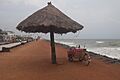
While the sea is a big attraction, Pondicherry's sandy beaches have mostly disappeared. This is due to the breakwater built for the harbor. The city is now protected by a seawall. The government is working to restore the sand. The Promenade Beach is one of the cleanest beaches in India.
The Sri Aurobindo Ashram is a very important spiritual center. It was founded by Sri Aurobindo, a freedom fighter and philosopher. Auroville, also known as the "City of Dawn," is an experimental town about 8 km (5.0 mi) from Pondicherry.
There are many old churches in Pondicherry, built in the 18th and 19th centuries. Near Promenade Beach, you can find many historical places. These include the Children's Park, the Dupleix Statue, the Gandhi statue, and the French War Memorial. Other notable spots are the Pondicherry Museum and the French Institute of Pondicherry.
The Puducherry Botanical Gardens are located south of the New Bus Stand. Chunnambar Backwater resort is 8 km (5.0 mi) from Pondicherry. It's a tropical resort by a creek.
Temples and Festivals
The Arulmigu Manakula Vinayagar Devasthanam is a Hindu temple dedicated to Ganesha. It existed even before the French settled in Pondicherry in 1666.
Sengazhuneer Amman Temple is one of the oldest temples in Pondicherry. It is in Veerampattinam village, about 7 km (4.3 mi) from the city center. A famous car festival is held here in mid-August every year.
Thirukaameeswarar Temple is in Villianur, a rural town about 10 km (6.2 mi) away.

Famous People from Pondicherry
Leaders
- V. Venkatasubba Reddiar, a well-known politician
- V. Subbiah, a leader for workers' rights and a freedom fighter
Arts and Literature
- Anandaraj, an actor
- Bharathidasan, a famous Tamil poet
- Kalki Koechlin, an actress
Science and Technology
- Yvonne Artaud, a French educator and psychologist
- Navi Radjou, an expert in innovation
- S. Somasegar, a former senior leader at Microsoft
- Ganapathi Thanikaimoni, a scientist
Military Figures
- Jacques Lauriston (1768–1828), a high-ranking French Army commander born in Pondicherry
Schools and Universities
- Jawaharlal Institute of Postgraduate Medical Education and Research
- Lycée français de Pondichéry (French school)
- Pondicherry Institute of Medical Sciences
- Pondicherry University
- Puducherry Technological University
- Rajiv Gandhi College of Veterinary and Animal Sciences
Images for kids
-
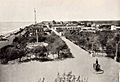
Pondicherry waterfront, around 1900
-
Rue De La Marine
-
Rue Saint Louis
-
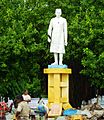
Nehru Statue
-
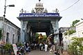
Gate leading into Manakula Vinayagar Temple in White Town
-
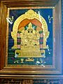
Tanjore painting of Manakula Vinayagar
-
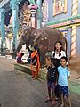
Devotees with Elephant Lakshmi in Manakula Vinayagar Temple
-
Beach by the Bay of Bengal
-
Bay of Bengal
-
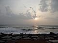
Early morning by the Bay of Bengal


See also
 In Spanish: Puducherry (ciudad) para niños
