
Karaikal facts for kids
Quick facts for kids
Karaikal
Karikal
|
|
|---|---|
|
Town
|
|
|
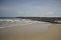
Karaikal Beach
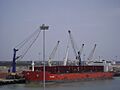
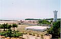
Karaikal Port
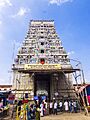
Sri Dharbaranyeswarar Temple at Tirunallar
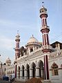
Karaikal Grand Mosque
Our Lady of Angels Church
Karaikal Lighthouse
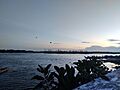
Arasalar River Estuary
Beach Road during Dawn
|
|

Karaikal
Location in Tamil Nadu
|
|
| Country | India |
| Union territory | Puducherry |
| District | Karaikal |
| Region | Tamil Nadu |
| Government | |
| • Type | Municipality |
| • Body | Karaikal Municipality (Conseil Municipal de Karaikal) |
| Elevation | 4 m (13 ft) |
| Languages | |
| • Official | Tamil, French |
| • Additional | English |
| Time zone | UTC+5:30 (IST) |
| PIN |
609601-609609
|
| Telephone code | +91-04368- |
| Vehicle registration | PY 02 |


Karaikal is a cool city in India, part of the Puducherry Union Territory. It's the main city of the Karaikal District and the second biggest city in Puducherry, right after Pondicherry. You can find it on the Coromandel Coast, right by the Bay of Bengal in South India. It's like a small piece of land surrounded by the state of Tamil Nadu.
Contents
What Does the Name Karaikal Mean?
Nobody is completely sure where the name Karaikal came from. One old book says it means 'fish pass'. The words 'Karai' and 'Kal' have many meanings. Some people think 'Karai' means 'lime mix' and 'Kal' means 'canal'. So, the name might mean 'a canal built of lime mix'. But there's no sign of such a canal today!
A Glimpse into Karaikal's Past
Karaikal has a long and interesting history, especially with the French.
How Karaikal Became French
In 1738, a ruler named Sayaji promised Karaikal to the French. He wanted their help. The French officially took control of the town in 1739. This happened with the help of a person named Chanda Sahib.
Changing Hands: French and British Conflicts
Later, in 1749, the French got even more land, including 81 villages. This was confirmed by a treaty in 1754. But Karaikal didn't stay with one owner for long! The French and British often fought over it. For example, in 1760, British forces captured the town after a ten-day fight.
Returning to French Control and Joining India
Karaikal finally went back to French control in 1817. This was after the end of the Napoleonic Wars. The French kept control, even though the British sometimes interrupted it. This lasted until 1954, when Karaikal became part of India. In 1962, Karaikal, along with other French areas like Mahé, Yanaon, Chandernagor, and Pondichéry, officially joined India.
Where is Karaikal Located?
Karaikal is a small area on the coast that used to be part of French India. It's one of the four parts that make up the Union Territory of Puducherry. The others are Pondicherry, Yanam, and Mahé.
Surroundings and Rivers
Karaikal is bordered by the Mayiladuthurai district to the north and the Nagapattinam district to the south. To the west, it has the Tiruvarur district. All these districts belong to the Tamil Nadu state. To the east, you'll find the beautiful Bay of Bengal.
The city is about 140 kilometers (87 miles) south of Pondicherry. It's also 158 kilometers (98 miles) east of Trichy. Karaikal is known for its rich culture.
Many branches of the Kaveri River flow through Karaikal. These include the Arasalar, Kudamurutti, and Virasolanar. These rivers help with irrigation for farming in the area. The land is mostly flat and slopes gently towards the Bay of Bengal.
Karaikal's Weather
Karaikal has a tropical wet and dry climate. This means it has hot weather with a rainy season.
How Karaikal is Governed
The District Collector is a very important official in Karaikal. They represent the Lieutenant Governor and help coordinate all government departments. The District Collectorate is the main office for the Karaikal District.
Karaikal is made up of the Karaikal municipality and several smaller areas called Communes:
- Nedungadu
- Kottucherry
- Neravy
- Thirunallar
- Tirumalarajanpattinam
- Poovam
- Varichikudy
People of Karaikal
According to the 2011 Census of India, Karaikal district has a population of 200,222 people. There are 97,809 males and 102,413 females. This means about 16% of Puducherry's total population lives in Karaikal.
Most people in Karaikal can read and write! The literacy rate is 87.1%. For males, it's 92.4%, and for females, it's 82.0%.
Culture and Traditions


Karaikal Ammaiyar was a famous saint who lived in Karaikal. She was one of the 63 Nayanars, who were devoted to Lord Shiva. Karaikal is also famous for the temple dedicated to Lord Saneeswara at Thirunallar.
Karaikal's Economy
Many people in Karaikal work in offices or factories. There are several industries here, like iron and steel mills, spinning mills, and factories making tiles, plastic, rubber, and chemicals. Many people also run their own businesses.
Farming and Fishing
The main ways people earn money in Karaikal are through farming and fishing. Karaikal is a coastal town with a coastline of 26 kilometers (16 miles). There are 12 big fishing villages. More than 25,000 fishermen and their families live in these villages. Their main jobs are fishing, selling fish, and other activities related to fishing.
Other Income Sources
Another important source of income comes from the liquor business. The taxes on liquor are lower here, so it's cheaper than in the nearby state of Tamil Nadu. Karaikal is also a place where the cost of living can be high. This is because many families from Karaikal live in France and visit or send money back home.
The ONGC also has an office in Karaikal. This company works with oil and natural gas.
Getting Around Karaikal
By Air: Karaikal Airport
Karaikal Airport is a new airport being built. It's special because it's the first airport in India built entirely with private money! The airport will have a runway and a terminal building. It will be able to handle smaller planes like the ATR-42. There are plans to make the airport bigger in the future.
By Sea: Karaikal Port
Karaikal port is a new deep-sea port. It's being built to help transport goods like coal, textiles, and cement. This port will be a good alternative to the busy ports in Chennai and Tuticorin. It's located right in the middle of the Tamil Nadu coast.
There are also plans to start a new ferry service between Sri Lanka and India. This ferry might depart from a port near Karaikal, like Nagapattinam.
By Road: Connecting Cities
The National Highway NH 32 goes through Karaikal. This highway connects Chennai and Thoothukudi. Karaikal is about 297 kilometers (185 miles) from Chennai and 132 kilometers (82 miles) from Puducherry. You can also reach it easily from cities like Tiruchirapalli, Kumbakonam, and Nagapattinam. Both government and private buses are available from Karaikal to many major cities.
By Rail: Train Connections
Karaikal has a railway line that connects it to Tiruchirapalli. This line goes through places like Thanjavur, Tiruvarur, Nagapattinam, and Nagore. You can catch trains from Karaikal to many cities, including Bangalore, Mumbai, Chennai, and Ernakulam. Work is also happening on a new railway line from Karaikal to Peralam.
Learning in Karaikal

Karaikal has a high literacy rate, meaning most people can read and write. There are many schools and colleges in the region.
Higher Education
- Jawaharlal Institute of Postgraduate Medical Education and Research (JIPMER) opened in Karaikal in 2016. It's a medical school where students are chosen through national entrance exams.
- National Institute of Technology Puducherry was started in Karaikal in 2010. Students get into this engineering college based on their scores in the Joint Entrance Examination – Main.
Famous People from Karaikal
- Peter Hein
- A.M.H. Nazeem
- K. N. Dandayudhapani Pillai
- M. O. H. F. Shahjahan
- K. A. Thangavelu
Images for kids
-
Karaikal Beach
-
Karaikal Port
-
Sri Dharbaranyeswarar Temple at Tirunallar
-
Karaikal Grand Mosque
-
Karaikal Lighthouse
-
Arasalar River Estuary
-
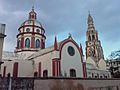
Our Lady of Angels Church
-

Beach Road during Dawn
See also
 In Spanish: Karaikal para niños
