
Divide County, North Dakota facts for kids
Quick facts for kids
Divide County
|
|
|---|---|

Divide County Courthouse in Crosby
|
|

Location within the U.S. state of North Dakota
|
|
 North Dakota's location within the U.S. |
|
| Country | |
| State | |
| Founded | 1910 |
| Seat | Crosby |
| Largest city | Crosby |
| Area | |
| • Total | 1,294 sq mi (3,350 km2) |
| • Land | 1,261 sq mi (3,270 km2) |
| • Water | 33 sq mi (90 km2) 2.6% |
| Population
(2020)
|
|
| • Total | 2,195 |
| • Estimate
(2022)
|
2,187 |
| • Density | 1.6963/sq mi (0.6549/km2) |
| Time zone | UTC−6 (Central) |
| • Summer (DST) | UTC−5 (CDT) |
| Congressional district | At-large |
Divide County is a county located in the northwest part of North Dakota, a state in the United States. As of the 2020 census, about 2,195 people live there. The main town and county seat (where the county government is) is Crosby.
Contents
History of Divide County
Divide County was created on December 9, 1910. Before that, it was part of Williams County. The people of Williams County voted to split their county into two parts. The southern part kept the name Williams County, and the northern part became the new "Divide County." The town of Crosby was chosen as its county seat.
The county's name, "Divide," comes from this split. It also sits on the Laurentian Divide. This is a special line where rainwater either flows north towards Hudson Bay in Canada or south towards the Gulf of Mexico in the United States.
In 1911, Divide County experienced one of the most serious tornadoes ever recorded in North Dakota. Sadly, four people lost their lives.
Geography and Nature
Divide County is in the very northwest corner of North Dakota. To the north, it shares a border with Canada, specifically with the province of Saskatchewan. To the west, it borders the state of Montana.
The land in Divide County has rolling hills and many lakes and ponds. It's a bit dry, but much of the land is used for farming. The county covers a total area of about 1,294 square miles (3,351 square kilometers). Most of this, about 1,261 square miles (3,266 square kilometers), is land, and 33 square miles (85 square kilometers) is water.
Divide County is also known for being part of the Bakken Formation. This is an important area for oil and natural gas production in the Williston Basin.
Main Roads
These are the most important highways that run through Divide County:
 U.S. Highway 85
 North Dakota Highway 5
 North Dakota Highway 40
 North Dakota Highway 42
Neighboring Areas
Divide County shares its borders with these counties and rural areas:
- Rural Municipality (RM) of Lake Alma No. 8, Saskatchewan (SK) - northwest
- RM of Souris Valley No. 7, SK - north
- RM of Cambria No. 6, SK - north
- RM of Estevan No. 5, SK - northeast
- Burke County - east
- Williams County - south
- Sheridan County, Montana - west
Lakes in Divide County
You can find these lakes in Divide County:
- Bright Water Lake
- McCone Lake
- Miller Lake
- Musta Lake
- North Lake
- Rattler Lake
- Round Lake (part)
- Willow Lake
People of Divide County
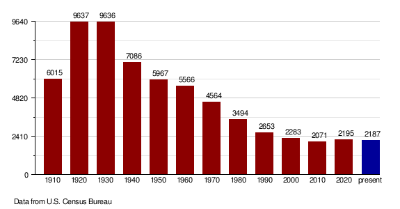
| Historical population | |||
|---|---|---|---|
| Census | Pop. | %± | |
| 1910 | 6,015 | — | |
| 1920 | 9,637 | 60.2% | |
| 1930 | 9,636 | 0.0% | |
| 1940 | 7,086 | −26.5% | |
| 1950 | 5,967 | −15.8% | |
| 1960 | 5,566 | −6.7% | |
| 1970 | 4,564 | −18.0% | |
| 1980 | 3,494 | −23.4% | |
| 1990 | 2,899 | −17.0% | |
| 2000 | 2,283 | −21.2% | |
| 2010 | 2,071 | −9.3% | |
| 2020 | 2,195 | 6.0% | |
| 2022 (est.) | 2,187 | 5.6% | |
| U.S. Decennial Census 1790-1960 1900-1990 1990-2000 2010-2020 |
|||
According to the census in 2020, there were 2,195 people living in Divide County. In 2010, there were 2,071 people and 977 households. Most people living in the county are white (98%). Many families have roots from Norway and Germany. The average age of people living here is about 51 years old.
Population Changes Over Time
Places to Visit
One interesting place to visit is Writing Rock State Historical Site. Here, you can see two ancient rock carvings called petroglyphs.
Towns and Communities
Cities in Divide County
Other Communities
These are smaller, unincorporated communities in the county:
- Alkabo
- Colgan
- Juno
- Kermit
- Paulson
- Stady
Townships
Divide County is also divided into smaller areas called townships:
- Alexandria
- Ambrose
- Blooming Prairie
- Blooming Valley
- Border
- Burg
- Clinton
- Coalfield
- Daneville
- De Witt
- Elkhorn
- Fertile Valley
- Fillmore
- Frazier
- Frederick
- Garnet
- Gooseneck
- Hawkeye
- Hayland
- Lincoln Valley
- Long Creek
- Mentor
- Palmer
- Plumer
- Sioux Trail
- Smoky Butte
- Stoneview
- Troy
- Twin Butte
- Upland
- Westby
- Writing Rock
Images for kids
-
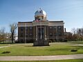
The Divide County Courthouse in Crosby, the county seat.
See also
 In Spanish: Condado de Divide para niños
