
Downtown Ossining Historic District facts for kids
|
Downtown Ossining Historic District
|
|
.jpg)
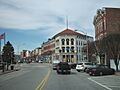
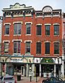
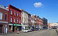
135 Main Street and buildings to west, 2010
|
|

Location in New York

Location in the United States
|
|
| Location | Ossining, New York |
|---|---|
| Nearest city | White Plains |
| Area | 25.8 acres (10.4 ha) |
| Built | 1840–1933 |
| Architect | Multiple |
| Architectural style | Renaissance, Italianate, Gothic Revival |
| NRHP reference No. | 88001827 (original) 12001133 (increase) |
Quick facts for kids Significant dates |
|
| Added to NRHP | August 9, 1989 |
| Boundary increase | January 2, 2013 |
The Downtown Ossining Historic District is a special area in Ossining, New York. It's like a time capsule of old buildings. This district is where the village's main business area, called the Crescent, has been for a long time. You can find many buildings here from the late 1800s and early 1900s. These include banks, churches, the village hall, and even the old post office and high school.
This area was officially recognized as a historic district in 1989. It was added to the National Register of Historic Places. This means it's an important place that shows how Ossining grew and changed over time. It's one of the few downtown areas in Westchester County that still looks much like it did in the past.
Some buildings in the district are extra special. The First Baptist Church of Ossining was listed on the Register even earlier, in 1973. The Old Croton Aqueduct, an old water tunnel, also runs through the district. It was listed in 1974 and became a National Historic Landmark in 1992. Famous architects like Robert W. Gibson and James Gamble Rogers designed some of the buildings here.
Ossining started growing in the late 1700s around this central spot. It became busy as factories, the Sing Sing prison, and the railroad developed along the nearby Hudson River. Ossining was actually the first village in Westchester County to become an official incorporated village. The downtown area was mostly built by the mid-1800s. However, two big things changed it later. The aqueduct was built to carry water to New York City, and some buildings had to be torn down. Also, several fires in the 1870s destroyed other buildings. Because of this, most of the buildings you see today were built between the 1870s and the early 1930s.
Later in the 1900s, some buildings on Main Street were removed as part of a city improvement plan. Other old buildings were lost in another fire. Not much was built to replace them for a while. Recently, the village has started new efforts to improve the area. Downtown Ossining is now home to many restaurants and shops. These often serve the growing Latin American and Portuguese communities who have moved here. A plan from the early 2000s has led to new rules for building in the area. These rules encourage a mix of homes and businesses. In 2013, the district was made larger to include Highland Cottage and other buildings.
Contents
Exploring Downtown Ossining
The historic district covers about 25.8 acres. It is shaped a bit like an upside-down "Y". Its borders mostly follow property lines and street edges. The district is built around South Highland Avenue (U.S. Route 9), which is the main road going north and south. Main Street leads west from there towards the river.
The district starts at 21–22 Croton Avenue, near the village municipal building. It includes the bank building at the corner of South Highland. Then it crosses the street and follows the back of properties on Main Street. This area is known as the Crescent because of the way the street curves. The district goes southwest, crossing the Old Croton Aqueduct trail. At Brandreth Street, it turns west to include properties up to 55 Central Avenue and 107 Main Street.

Then it goes back east along Main Street, crossing the aqueduct again. It turns south to follow the back of properties along South Highland, including two shops and Trinity Episcopal Church. It returns to South Highland at Maple Place. It follows the east side of the road to Emwilton Place, where it turns east to include Ossining United Methodist Church. Past the church, it turns north again to include all the buildings of Ossining High School. It does not include the school's newer sports fields. At the high school's north edge, it turns west again. It follows the back of properties on South Highland, going back to Village Hall.
There are 37 buildings and structures in this area. Most of them are commercial buildings, usually two or three stories tall and made of brick. The others are public buildings, like churches or government offices. All but 14 of these buildings are considered "contributing properties." This means they add to the historic importance of the district.
The land inside the district slopes gently down to the north and west. This leads to steeper drops towards the Sing Sing Kill gorge and the Hudson. Because it's so close to these bluffs, the district offers great views across the Hudson River. To the east and south are Ossining's neighborhoods where people live. In 2013, the district was made bigger to include Highland Cottage, which is also listed on the National Register.
Ossining's plan from 2009 suggested making the historic district larger. Four small areas were proposed to be added. These included more properties on Central Avenue, an expansion along Main Street, Highland Cottage, and a building near the municipal building. The U.S. National Park Service approved these additions to the district in 2013.
A Look Back at Ossining's History
The downtown area of Ossining grew in several clear steps. In the early days, it was mainly a busy crossroads. Most of the district's buildings, including the four churches, were built or rebuilt along Main Street in the late 1800s. New construction then moved to Highland Avenue in the early 1900s. This is when important public buildings were added. Since then, the community has focused on saving and improving these historic buildings.
Early Days: From Manor to Village
Frederick Philipse bought the land that is now Ossining from the Sint Sinck Native American tribe in 1685. His large estate, called Philipsburg Manor, stretched a long way. During the American Revolutionary War, Frederick III, the last owner, supported the British. So, New York State took his land in 1779.
Growing as a Crossroads and Port
After the war, the huge Philipse family lands were divided and sold. Elijah Hunter, a war officer, bought the land south of Sing Sing Kill. He started prayer meetings, and his group became the First Baptist Church of Ossining in 1790.

The riverfront became the center of early growth. Farmers from inland brought their crops here to be shipped to New York City. Main Street connected this port to the Albany Post Road, which is now US 9. To help even more farmers, the Croton Turnpike (now NY 133) was built in the early 1800s.
People and businesses started to gather around the crossroads. The Union Hotel became a popular stop for travelers. The local Presbyterian church built its first meeting place in 1803. By 1813, the area became Sing Sing, Westchester's first official village. The First Baptist Church built its first building in 1815. In 1820, the Post Road was moved, which helped Sing Sing grow even more. Five years later, the economy got another boost when the state built Sing Sing, one of its first prisons, near the village. Marble from the prison's quarry was used to build many local buildings, including Ossining's oldest church, St. Paul's.
The churches grew with the village. In 1834, the Baptist church was updated. The Presbyterians built a new Greek Revival church. Many commercial buildings in that style were torn down when the Old Croton Aqueduct, a water tunnel, was built in 1839. This aqueduct carried water from the Croton Dam to reservoirs in Central Park. The oldest building still standing from before the American Civil War is the Italianate house at 23 South Highland. It is one of the few homes in the district.
The Railroad Arrives in Ossining
In the mid-1800s, the Hudson River Railroad was built along the river. This made it possible to reach New York City in about an hour. Ossining's population grew by over 50 percent between 1845 and 1855. The railroad helped farming businesses and led to new factories like Benjamin Brandreth's pill factory. But it hurt older businesses like boat-building and hotels along the Albany Post Road. In 1850, the First National Bank built its first building at the corner of South Highland and Croton.

Not much new construction happened during the 1860s because of the Civil War. The Olive Opera House at 63-67 Central Avenue, built around 1865, is the oldest non-home building in the district. Some buildings on Croton Avenue and Main Street also date from this time. After the war, the village built a monument to the soldiers who died fighting for the Union Army.
A Time of Growth and Rebuilding
The years after the Civil War were very good for Ossining. While river shipping faded, quarrying continued. The village became a busy industrial center. There were over a hundred small businesses downtown or by the waterfront.
In the late 1870s, church groups decided to expand. The Presbyterians needed a bigger building. They sold their old one to the new Trinity Episcopal Church. Trinity Church had separated from St. Paul's over disagreements about the war. The new Presbyterian church was designed by Isaac Perry, who later became New York's state architect. It was the first of four churches built downtown in the late 1800s.
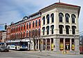
The other buildings in the district were mainly built after four big fires. The first fire in 1871 mostly affected the north part of the district. The village lost all its records stored in a basement. In 1872, another fire destroyed all the buildings on lower Main Street. After this, the Barlow family built the Barlow Block at 129–139 Main Street. They wanted it to be the main shopping area in Ossining.

In 1874, another fire damaged the Olive Opera House and nearby buildings. After rebuilding, 145 Main Street was redone in the Renaissance Revival style. On the other side, 61 Central kept its unique cast iron storefront.
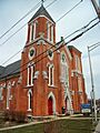
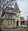
Further up the street, 187 Main was built in 1874. Across the street, the Baptists replaced their old church. The new brick Gothic Revival church, designed by J. Walsh, is a beautiful example of that style in Ossining.

The last fire, in 1876, burned the block across Main from the Baptist Church. This rebuilding also brought new architectural styles. The buildings at 191 and 193 Main became Palmer Hall and the Stayver Building. They are brick buildings with Neo-Grec metal details. Italianate details were added to 199 Main Street, which became the Keenan Building in 1878.
In the 1880s, new buildings filled the empty space next to the aqueduct on Main Street. These included 165 and 173–75 Main. Another Renaissance Revival building, 127 Main Street, was finished in 1885. It has fancy details like two-story brick pilasters.
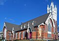
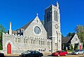
That same year, the Methodists finished their new church at Highland and Emwilton. It was designed by Ebenezer Roberts and Lawrence P. Valk. This church is known for its colorful stone bands on the outside. It also has a special Favrile glass window signed by Louis Comfort Tiffany.

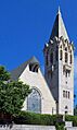
Trinity was the last of the downtown churches to be built. After almost 20 years in the old Presbyterian building, the Episcopalian group needed their own space. They hired Robert W. Gibson to design it. Trinity Church was finished in 1891. It is the only Neo-Gothic Revival religious building in the district.
In the early 1890s, the old Union Hotel was torn down. A new doctor's office building replaced it. In 1892, part of the Barlow Block became Ossining's first post office. The next year, the village's electric trolley system started. This made it easier for people to travel downtown.
The new century brought big changes, starting with the village's name. In 1901, Sing Sing officially changed its name to Ossining. This was to avoid being linked to the prison. In 1906, Sparta, a nearby area, became part of the village.
Around 1900, another Renaissance Revival commercial building was built at 181–183 Main Street. In 1905, a parish hall was added to Trinity Church, giving it a unique U-shape. The next year, the corner of the Barlow Block was remodeled into a fancy Renaissance Revival bank building. It was designed to look like St. Mark's Library in Venice.

This led to the first major building of the new century, the Bank for Savings Building at 200 Main Street. Built in 1907, this stone building is the only example of the Beaux-Arts style in the village. It stands out as a landmark for people entering Ossining from the north.
Public Buildings and Modern Changes
Other new buildings continued to use older styles. In 1911 and 1913, new brick commercial buildings went up at 189 and 205 Main Street in the Renaissance Revival style.
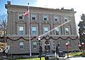
In 1914, the village got its own new municipal building. This stone building at 16–20 Croton Avenue was built in the Classical Revival style. This style was popular for government buildings back then. It was designed by Donn Barber, a famous architect.

Later that year, a new architectural style appeared in the district. The Spanish Colonial Revival commercial building at 201–203 Main Street had a tiled roof and stucco walls. Down the street at 125 Main, a 1920 building used yellow brick and limestone trim.
The early 1920s brought more changes as Ossining's population grew. In 1920, the prison stopped some of its industries, including quarrying. Two years later, the Olive Opera House closed and became a factory. In 1924, the trolley system was shut down because more people owned cars. Buses replaced the trolleys.
The last important buildings in the future historic district were built on South Highland at the end of the 1920s. The Cynthard Building, a one-story commercial building, was built in 1930. Also that year, the First National Bank moved into the district's only Art Deco building at 13 Croton Avenue.

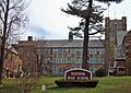
Ossining High School was the most notable addition that year. The old high school was too small for the growing number of students. Voters approved a new building in 1929. James Gamble Rogers was the architect. He was known for his college campus buildings. The new high school was built in the Collegiate Gothic style. It looks similar to Harkness Tower at Yale University, which Rogers also designed.
Saving and Renewing Downtown
As the Great Depression began, construction slowed. One more public building completed the district. The post office needed a bigger space. As part of national relief programs, many new post offices were built. Arthur Ware designed a simple Classical Revival brick building at 10 South Highland. It was finished in 1933. This is the newest contributing property in the district.
The district was now mostly built. In 1934, Woolworth's moved into 201–203 Main Street. The government of the Town of Ossining moved into Village Hall the next year.
After World War II, the population grew. Two buildings were expanded in the late 1950s. The Presbyterian Church got a new Sunday School wing in 1955. Two years later, the high school also added a new wing.
Later in the 1950s, the aqueduct started carrying less water. New York City didn't need as much water from it anymore. By the early 1950s, the city stopped using it.
Cars became the main way people traveled. New roads were built. In the 1970s, a plan to build a highway along the Hudson River was canceled. But funds meant for city improvements were still available.
Like many other downtowns, Ossining was affected by the rise of cars. People started shopping at malls and strip malls outside the village. The village used its improvement funds to tear down old buildings on the south side of Main Street. This was an attempt to make downtown better. However, new projects were not funded, and the spaces became parking lots. Ossining went through many different mayors in the late 1900s, and many plans were not completed.
The 1971 plan recognized the importance of the buildings on the north side of Main Street. Saving historic buildings became more important. In 1973, the First Baptist Church of Ossining was the first Ossining building listed on the National Register. The aqueduct followed in 1974. In 1975, the village studied how to fix up downtown. It suggested building more homes downtown to help businesses. But no new projects happened. A second plan in 1977 also failed, but it suggested keeping new buildings similar in size to old ones.
.jpg)
As the village continued to change leaders, social and economic trends affected downtown. All three bank buildings became empty. The widening of Route 9 also caused 217 Main Street to lose some of its sections. It was rebuilt, but it lost too much of its original look to be considered a contributing property when the historic district was created in 1989. Many businesses that closed were replaced by new ones, especially restaurants. These new businesses served the growing Latin American immigrant population.
In the 1990s, the village started planning again. A farmers' market began in 1990 and is still going strong. New rules were made for building in the district. A Historic Review Commission was created to make sure new buildings fit in. The plan also recognized the importance of the growing number of restaurants downtown. In 1992, the aqueduct became a National Historic Landmark. In 1993, the old Greek Revival buildings at 147–55 Main Street burned down. The village used the space as a parking lot.

Changes came to two newer buildings on South Highland around the year 2000. The post office moved to a new building. Its old building was turned into shops. The Cynthard Building was damaged by a fire in 2003 and was closed for three years for repairs. In 2004, the village took over the Bank for Savings building, which had been empty since 1983. Two years later, a developer bought the Ossining National Bank Building. They started fixing it up to create affordable homes.
Ossining hired its first full-time planner in 2005. A new plan for the village was finished in 2007 and adopted in 2009. It suggested creating a new zoning area called Village Center for Main Street. This was quickly put into place. In 2011, the village asked for ideas to redevelop the Bank for Savings building and the 147–155 Main Street properties. In 2015, a new complex with homes, restaurants, and shops opened in the latter buildings.
Important Buildings in the District
Among the district's 23 important buildings and structures, many are special because of their architecture or history. Two of them are listed individually on the National Register. One of those, the Old Croton Aqueduct, is a National Historic Landmark.
National Register of Historic Places Sites
- First Baptist Church of Ossining, 1 Church Street. This church was designed by J. Walsh in 1874. It has a High Victorian Gothic style with many triangles and quatrefoils in its decorations. These shapes represent the Trinity and the four Gospels. This church is home to Ossining's oldest group of worshippers, started in the 1780s. It was the first Ossining property listed on the National Register in 1973.
- Highland Cottage, 36 S. Highland Ave. This Gothic-style house from 1872 was the first concrete house in Westchester County. It was later used as a business school.
- Old Croton Aqueduct, space between 165 and 173 Main Street. This old water tunnel is 5 by 7 feet and about 20 feet underground. A walkway on top, paved with brick in the downtown area, leads north to the Croton Dam. It was an amazing engineering feat when built in the late 1830s. It was New York City's first clean water supply. While other aqueducts now supply the city, its northern end still provides water to Ossining and other towns. It was listed on the Register in 1974 and became a National Historic Landmark in 1992.


Other Important Buildings
- Bank for Savings, 200 Main Street. This stone building from 1907 is a key landmark for traffic entering downtown Ossining from the north. It is the only example of the Beaux Arts style in the village.
- Barlow Block, 129–139 Main Street, including Ossining National Bank Building. This block is named after the Barlow family. They rebuilt their store here after a fire in 1872. The buildings are fancy Italianate style with pediments and bracketed cornices. The building at the north end was later remodeled into the Renaissance Revival bank building in 1906. After being empty for a long time, it has been fixed up and turned into affordable housing.
- Building at 61 Central Avenue. Built in 1875, this two-story brick commercial building has a unique cast iron storefront with columns on tall blocks.
- Building at 125 Main Street. This 1920 building is the only one in the district that uses yellow brick and limestone trim.
- Building at 127 Main Street. This more detailed Renaissance Revival building, with brick pilasters and a metal cornice, dates to 1885.
- Building at 141–145 Main Street. This was one of the first buildings in the district to use the Renaissance Revival style after being rebuilt following a fire in the 1870s.
- Building at 189 Main Street. This 1911 Renaissance Revival building is unique for its stone quoins and belt courses.
- Building at 201–203 Main Street. This 1914 building is the only example of the Spanish Colonial Revival style in the district, with its tiled roof and stucco face.
- Building at 205 Main Street. All the decorations on this 1913 Renaissance Revival building are made of brick, which is special in the district.
- Cynthard Building, 26 South Highland Avenue. This one-story building, built in 1929, has a terra cotta face and neoclassical details. It was built where the old Union Hotel used to be. It was renovated after a fire in 2003.
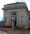
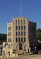
- First National Bank, 13 Croton Avenue. Located at the corner with North Highland Avenue, this 1930 building is the only Art Deco style building in the district. It is also the only one of the three bank buildings still used as a bank.
- First Presbyterian Church, 34 South Highland Avenue. Isaac G. Perry designed this High Victorian Gothic brick church in 1870. A Sunday School wing was added in 1955.
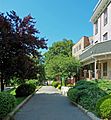
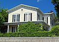
- House at 23 South Highland Avenue. This wood frame house from the 1840s is the oldest building in the district. It is one of only two homes here.
- Keenan Building, 199 Main Street. This building replaced an earlier one damaged by fire in the 1870s. It was built in a high Renaissance Revival style.
- Old U.S. Post Office, 30 South Highland Avenue. Arthur Ware designed this detailed Classical Revival building in 1933. It was part of a big building program during the New Deal. It served as the post office until a new one was built. Now, it is a retail space.
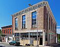
- Olive Opera House, 63–67 Central Avenue. Built in 1865, this three-story brick building was originally a performing arts and meeting space until the early 1920s. Since then, it has been a factory and now a commercial building.
- Ossining High School, 29 South Highland Avenue. James Gamble Rogers designed the original Collegiate Gothic building in 1930. It served all secondary students. After an expansion in 1958, it now serves only high school students from Ossining and parts of nearby towns.
- Ossining Municipal Building, 16 Croton Avenue. This stone Classical Revival building was built in 1914 by Donn Barber. It has housed the village government and, since 1934, the town government too.
- Ossining United Methodist Church, South Highland Avenue and Emwilton Place. This church, built in 1885, is one of the few surviving churches by Ebenezer Roberts. It has colorful stonework. A Louis Comfort Tiffany stained-glass window is inside.
- Palmer Hall and Stayver Building, 191–93 Main Street. These two Renaissance Revival buildings replaced structures lost to the 1876 fire. They are known for their Neo-Grec details.
- Trinity Episcopal Church, 7 South Highland Avenue. This church was built in 1891 and designed by Robert W. Gibson. It was the last of the district's four churches to be built. A parish house wing added in 1905 gives it a unique U-shaped layout.
Rules for Building and Planning
Ossining has special rules for downtown called "Village Center" zoning. These rules aim to keep downtown as the main center of village life. They encourage businesses and mixed-use buildings, where homes are on upper floors and shops are on the ground floor. For homes, there must be a separate entrance from the shops. No homes are allowed on the ground floor.
The historic district is also part of a "historic overlay district." This means it has extra rules to protect its history. The Historic Preservation Commission (HPC) oversees this. It has seven local residents who decide on landmark status and preservation plans.
All new construction in the district needs approval from the village's Planning Board. The Planning Board also acts as the Board of Architectural Review (BAR). They can reject buildings if they don't fit the look of other buildings nearby. If someone is not happy with a decision, they can appeal to the Zoning Board of Appeals (ZBA).
Future Plans for Downtown
Ossining's 2009 plan for the village has three main goals for downtown. These are to help businesses, create a major attraction for visitors, and improve the area's features. The plan suggests specific actions to achieve these goals.
To help businesses, the plan recommends making it easier for businesses to work with the village government. It also suggests improving the zoning process. Creating a business improvement district and hiring a Main Street Manager would help downtown businesses grow.
During the planning process, many residents wanted a big national store or restaurant to come downtown. However, the plan suggests this might not be a good idea. Large chains often prefer to be near other chains in big shopping centers. This would not fit well in downtown Ossining. Also, Ossining is not wealthy enough or easy enough to reach from major highways for many chains. The Hudson River also cuts the potential shopping area in half.

Instead, the plan suggests building on the existing groups of restaurants and home-furnishings stores. Some local businesses already attract customers from all over the county. The plan also recommends adding more cultural activities downtown. It suggests promoting more homes and offices to bring more people downtown throughout the day.
Residents also complained that the parking lots were ugly and that finding parking was hard. The plan suggests creating a village green (a park-like area) on part of a parking lot. This could be a central gathering spot. It could still have parking along the sides or even an underground garage. More parking could be added in an above-ground garage on Brandreth Street. The village should also make sure new buildings fit in. It should make signs and lighting consistent. And it should strongly enforce its historic preservation rules.
The plan also recommended better connections between downtown and the waterfront. The Metro-North train station and the Haverstraw–Ossining Ferry could bring visitors without adding to parking problems. The plan says that connecting the waterfront and downtown will help both areas. It will give visitors more reasons to stay longer in Ossining. The plan also suggests studying a shuttle bus service. This would help visitors get from the waterfront to downtown and other parts of the village. Other ideas include better signs, walkways, and lighting.
In 2019, the village started updating the plan. A committee was formed, and the village looked for a planning firm to help.
Expanding the District and Agency Powers
The plan recommended that the village expand the historic district, at least in its local zoning rules. A map shows the southern border expanding to include Highland Cottage. At the northern end, a property on Croton Avenue would be included. The west end would extend to Central Avenue and Main Street. The U.S. National Park Service approved this expansion in early 2013.
The plan also recommended putting up signs for the historic district and maps. It suggested giving the village's regulatory bodies more power. It called for the Historic Preservation Commission's decisions to be binding. The design guidelines should be improved and made official. This would ensure that new buildings fit in with the existing historic buildings.
Images for kids
-
135 Main Street and buildings to west, 2010
-
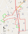
Map showing original district boundaries in red and 2013 additions in green
-

Looking North from Ossining, an 1867 Samuel Colman painting
-
Isaac Perry's First Presbyterian Church, 34 South Highland Avenue
-
The 1874 First Baptist Church, 1 Church Street
-
Palmer Hall and Stayver Building, 191 and 193 Main Street
-
Trinity Episcopal Church, 7 South Highland Avenue
-
Bank for Savings building, 200 Main Street
-
Village Hall, 16 Croton Avenue
-
Ossining High School, 29 South Highland Avenue
-
The aqueduct walkway
-
Main Street in 2009, with redevelopment of the National Bank building underway at rear
-
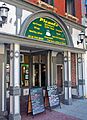
A Latin-themed coffeehouse at 193 Main Street, 2012
-
Highland Cottage, 36 S. Highland Avenue
-
The Barlow Block and National Bank Building, 129–139 Main Street
-
First National Bank building, 13 Croton Avenue
-
Olive Opera House, 63–67 Central Avenue
-
House at 23 South Highland Avenue
-
Ossining United Methodist Church, Highland Avenue and Emwilton Place

