DuPont, Washington facts for kids
Quick facts for kids
DuPont, Washington
|
|||
|---|---|---|---|

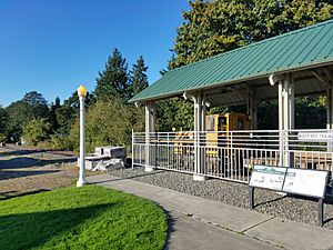
DuPont dynamite train exhibit in DuPont Village
|
|||
|
|||

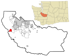
Location of DuPont, Washington
|
|||
| Country | United States | ||
| State | Washington | ||
| County | Pierce | ||
| Incorporated | April 15, 1951 | ||
| Government | |||
| • Type | Mayor–Council | ||
| Area | |||
| • Total | 5.85 sq mi (15.15 km2) | ||
| • Land | 5.82 sq mi (15.07 km2) | ||
| • Water | 0.03 sq mi (0.08 km2) | ||
| Elevation | 249 ft (76 m) | ||
| Population
(2020)
|
|||
| • Total | 10,151 | ||
| • Estimate
(2021)
|
10,112 | ||
| • Density | 1,635.33/sq mi (631.41/km2) | ||
| Time zone | UTC-8 (PST) | ||
| • Summer (DST) | UTC-7 (PDT) | ||
| ZIP code |
98327
|
||
| Area code(s) | 253 | ||
| FIPS code | 53-18965 | ||
| GNIS feature ID | 1513919 | ||
DuPont is a city located in Pierce County, Washington, United States. In 2020, about 10,151 people lived there. DuPont was originally a "company town," meaning it was built and run by a company. The city is named after the DuPont chemical company. This company made explosives in the area from 1909 to 1975.
Contents
History of DuPont
People have lived in the DuPont area for at least 10,000 years. The Nisqually Tribe lived peacefully in their homeland, which covered a large area near present-day Olympia, Tenino, and DuPont. Their lives changed when Europeans and Americans began settling there about 150 years ago. The Nisqually people ate shellfish from the beaches and salmon from Sequalitchew Creek.
Early Explorers and Settlements
In 1792, Captain George Vancouver mapped this area. Later, in 1833, the Hudson's Bay Company set up a fur trading post called Fort Nisqually. It was a stop between other forts. In 1843, the fort moved to a new spot to make room for more workers and get better access to fresh water.
On July 5, 1841, Charles Wilkes of the United States Exploring Expedition held the first American Independence Day celebration west of the Mississippi River in what is now DuPont.
Schools and Land Changes
The first school in the area was the Nisqually Methodist Mission school, which ran from 1840 to 1842. Chloe A. Clark was the teacher there. The first public school opened in 1852.
After the Oregon Treaty of 1846, the land became part of the U.S. but the Hudson's Bay Company could still operate. However, American farmers wanted the land. They started their own markets and settled on company property. By 1869, the Hudson's Bay Company sold the land to the U.S. government for $650,000 and closed the fort.
The DuPont Company Era
Once the Hudson's Bay Company left, farmers bought the land. In 1906, the DuPont chemical company bought about 5 square miles (13 km2) from these farmers. They wanted to build a plant to make explosives. The plant was built on the original Fort Nisqually site and finished in 1909.
For almost 70 years, the plant made dynamite for the U.S. military. It also made dynamite for big construction projects like the Grand Coulee Dam, the Alcan Highway, and the Panama Canal.
A company town was built about a mile east of the explosives plant. By 1909, the village had houses for managers and workers. By 1917, there were over 100 houses. The village became known as the town of DuPont in 1912. It officially became a city in 1951 when the company started selling the houses to its employees. The old company town is now a historic district.
Modern Development
The dynamite plant closed in 1975. The Weyerhaeuser company bought the land. They first planned to build a lumber export plant. But later, they decided to develop the town into a modern planned community.
Starting in 1991, DuPont, Weyerhaeuser, and the Department of Ecology cleaned up the old explosives plant site. A golf course called The Home Course was built where the plant used to be. Today, DuPont has grown into a modern community called "Northwest Landing." The city expects to have more than 12,000 people living there.
In 1975, an ancient shell mound, called a midden, at the Sequalitchew Archeological site was added to the National Register of Historic Places. It is the oldest known midden in Washington.
Present Day Life
DuPont continues to be a growing community. The Steilacoom Historical School District serves the city. Chloe Clark Elementary School, which used to teach kindergarten through fifth grade, became very full. Now, Chloe Clark Elementary and Cherrydale Primary in Steilacoom teach grades K-3. Saltar's Point Elementary in Steilacoom teaches 4th and 5th grades. Pioneer Middle School moved to DuPont in 2008.
DuPont has different neighborhoods, each with its own style. Northwest Landing is the most famous. Hoffman Hill is the largest area and home to most of the people. The Historic Village is the only part of DuPont that is not a modern planned community. Bell Hill is considered the most expensive area. DuPont has many trails and green spaces for outdoor activities.
On December 18, 2017, an Amtrak train derailed near DuPont. Three people died and more than 100 others were hurt.
Geography
DuPont is located at 47.099070 degrees North latitude and 122.637544 degrees West longitude.
The city covers a total area of about 5.88 square miles (15.23 square kilometers). Most of this area, about 5.86 square miles (15.18 square kilometers), is land. Only a small part, about 0.02 square miles (0.05 square kilometers), is water.
Sequalitchew Creek Trail and Beach
Within DuPont, near the city hall, you can find the Sequalitchew Creek trail. This trail follows an old railway path that once led from the explosives plant to Puget Sound. The trail goes down to Sequalitchew Beach.
The creek area is home to many animals. You might see bald eagles, hawks, songbirds, herons, ducks, owls, frogs, snakes, beavers, raccoons, coyotes, deer, and rabbits. In the waters off Sequalitchew Beach, you might spot harbor seals, marbled murrelets, and even gray whales.
Other Trails and Wildlife Areas
DuPont also has other trails and parks where you can see wildlife and enjoy outdoor activities. The city's trail system connects different natural areas while still feeling like part of the city. You can get maps of the trails from the visitor center, city hall, or the history museum.
Population Information
| Historical population | |||
|---|---|---|---|
| Census | Pop. | %± | |
| 1920 | 600 | — | |
| 1960 | 354 | — | |
| 1970 | 384 | 8.5% | |
| 1980 | 559 | 45.6% | |
| 1990 | 592 | 5.9% | |
| 2000 | 2,452 | 314.2% | |
| 2010 | 8,199 | 234.4% | |
| 2020 | 10,151 | 23.8% | |
| 2021 (est.) | 10,112 | 23.3% | |
| U.S. Decennial Census 2020 Census |
|||
2010 Census Details
In 2010, there were 8,199 people living in DuPont. There were 3,023 households, and 2,185 families. The city had about 1,399 people per square mile (540 per square kilometer).
Most residents were White (68.7%). Other groups included African American (8.1%), Asian (10.2%), Native American (0.5%), and Pacific Islander (1.1%). About 9.7% of the population was Hispanic or Latino.
In 47.6% of households, there were children under 18. About 58.0% of households were married couples living together. The average household had 2.71 people, and the average family had 3.27 people.
The average age in the city was 32 years old. About 33.4% of residents were under 18. About 37.1% were between 25 and 44 years old.
Education
The city of DuPont is part of the Steilacoom Historical School District. Students attend Steilacoom High School.
See also
 In Spanish: DuPont (Washington) para niños
 | Emma Amos |
 | Edward Mitchell Bannister |
 | Larry D. Alexander |
 | Ernie Barnes |


