Sequalitchew Creek facts for kids
Quick facts for kids Sequalitchew Creek |
|
|---|---|

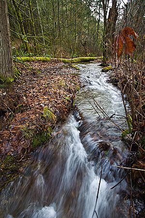
Sequalitchew Creek, lower canyon
|
|
| Lua error in Module:Location_map at line 420: attempt to index field 'wikibase' (a nil value).
Location of the mouth of Sequalitchew Creek in Washington
|
|
| Physical characteristics | |
| Main source | Sequalitchew Lake |
| River mouth | DuPont Warf, Nisqually Reach |
| Length | 38.4 mi (61.8 km) |
| Basin features | |
| Watershed | Chambers-Clover Watershed |
Sequalitchew Creek is a natural waterway located in DuPont, Washington. It starts from Sequalitchew Lake near Fort Lewis, Washington. This area was once home to the first Fort Nisqually trading post, built in 1833 by the Hudson's Bay Company. The creek's natural path flows from Sequalitchew Lake, through Edmonds Marsh, down a canyon, and into the Puget Sound.
Contents
History of Sequalitchew Creek
Early Settlements and Explorations
- In 1832, Archibald McDonald from the Hudson's Bay Company chose the spot for what would become Fort Nisqually.
- Working with the Nisqually people, a storage building for blankets, seeds, and potatoes was built at the mouth of Sequalitchew Creek.
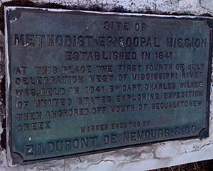
- In 1839, the Nisqually Methodist Episcopal Mission was set up. This brought the first U.S. citizens to the Puget Sound area near the creek canyon.
- In 1841, the Wilkes U.S. Exploring Expedition used a high spot near the creek to map the Puget Sound waters. They joined the Americans at the mission to celebrate the first Fourth of July west of the Mississippi River.
- In 1843, the second Fort Nisqually was built. It focused more on farming and was moved to a flat area near Sequalitchew Creek.
- In 1904, the first joint Army-National Guard training happened on the west coast. A large camp near Sequalitchew Creek included the "Buffalo Soldiers" of the 9th Cavalry.
Fish Farming and Native Fishing
From 1959 to 1960, the Washington Department of Fisheries used Sequalitchew Lake as a fish farm. They raised and released coho salmon into Sequalitchew Creek. Later, from 1976 to the mid-1990s, the department ran a coho salmon hatchery on Sequalitchew Lake. In the past, Native Americans would catch a lot of fish, sometimes 3,500 to 4,000 fish each year, from Sequalitchew Creek.
The Path of Sequalitchew Creek
The entire area that drains into Sequalitchew Creek is about 38.4 square miles (99 km2). This area starts at Kinsey Marsh. Water from Kinsey Marsh flows through Murray Creek into American Lake. When American Lake overflows, its water feeds Sequalitchew Lake. Both lakes keep their water levels steady all year thanks to springs and groundwater.
Around 1950, Fort Lewis built a dam near the start of the creek. This dam sends water through a canal that begins in Hamer Marsh, east of the creek. South of Sequalitchew Lake, this canal goes under the creek using a series of pipes. It then goes west for one mile (1.6 km) before turning north. Finally, it empties into Puget Sound at Tatsolo Point. The original creek bed still carries water from groundwater runoff. This water follows the historic path and also flows into the Puget Sound.
Exploring the Creek Trail and Beach
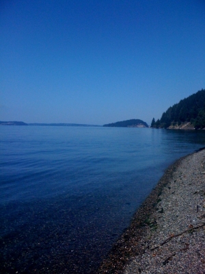
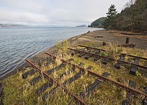
You can explore this area on an old railway path. This path used to connect the DuPont Company area to Puget Sound. The trail leads to Sequalitchew beach. Many different animals use the creek area. These include eagles, hawks, songbirds, herons, ducks, and owls. You might also see frogs, salamanders, snakes, beavers, raccoons, coyotes, deer, and rabbits. In the waters off Sequalitchew Beach, you can find harbor seals and gray whales.
Proposed Mining Expansion Near the Creek
A company called Cal-Portland (formerly Glacier Northwest) wants to make its gravel mine bigger. This plan would involve clearing 184 acres (0.74 km2) of forest and topsoil around Sequalitchew Creek. If this happens, it would create a 550-acre (2.2 km2) hole in the ground. About 40 million tons of gravel would be dug out over 14 years.
This pit would be 80 feet (24 m) deep and reach the underground water source called the Vashon Aquifer. Water from this aquifer (about 6.5 million gallons per day) would be sent into Sequalitchew Creek. This would make the creek's flow eight times bigger than it is now. Digging out this water would also lower the groundwater level nearby by as much as 30 feet (9.1 m). This could drain Edmonds Marsh, which is an important wetland. Other nearby wetlands like Pond Lake, McKay Marsh, Bell Marsh, and Hammer Marsh would also be negatively affected.
City of DuPont's Recommendation
On January 16, 2009, the DuPont Planning Department suggested approving the mining expansion with some changes. Their recommendations included:
- Allowing the mine to expand into the 177 acres (0.72 km2) area.
- Allowing the company to remove groundwater to reach more gravel. This would happen using wells at first. Later, a new creek channel would be built to permanently collect groundwater and send it to the existing Sequalitchew Creek.
- To make up for the impact on Edmonds Marsh, they suggested replacing invasive plants with native ones. This would help the wetland stay healthy.
- Allowing the removal of the "Kettle Wetland." New wetlands would be created nearby to replace it.
- Allowing the changes to wetlands near Sequalitchew Creek due to groundwater removal. New wetlands would be created to make up for this.
- The plan would not allow digging on the north side of the existing Sequalitchew Creek canyon. Instead, a pipe about 500 feet (150 m) long would be installed underground.
The mining company's permit to expand the mine and remove groundwater goes against a 1994 agreement made by the Nisqually Delta Association. DuPont's own city rules protect wetlands. Even though DuPont signed the 1994 agreement and has its own rules, the city did not stop the company from applying for the mining expansion. The groups involved in the 1994 agreement are now meeting to decide what to do next.
Future Plans for Sequalitchew Village
The City of DuPont's 2008 plan for land use describes future plans for the mining area. It suggests that the area around Sequalitchew Creek, including where groundwater would be removed, could become a neighborhood called Sequalitchew Village. This village could have about 2,138 homes.
Memorandum of Understanding Discussion
A special agreement, called a Memorandum of Understanding, was created about the mining expansion. This document was presented to the city council on October 13, 2009, for them to sign. Some council members were worried because the public had not had a chance to review it. Now, the public is being asked for their thoughts. After that, the document will be looked at again at a meeting on November 10, 2009.
Animals Living in Sequalitchew Creek
In 1982, a study found many different animals living in and around the creek.
Fish Species
Bird Species
- Common loon
- Red-throated loon
- Red-necked grebe
- Horned grebe
- Pied-billed grebe
- Double-crested cormorant
- Green heron
- Mallard
- Gadwall
- Pintail
- Green-winged teal
- Blue-winged teal
- American wigeon
- Northern shoveler
- Wood duck
- Ring-necked duck
- Canvasback
- Greater scaup
- Lesser scaup
- Common goldeneye
- Bufflehead
- White-winged scoter
- Surf scoter
- Black scoter
- Ruddy duck
- Red-breasted merganser
- Turkey vulture
- Sharp-shinned hawk
- Cooper's hawk
- Red-tailed hawk
- Bald eagle
- Osprey
- American kestrel
- Blue grouse
- Ruffed grouse
- California quail
- Ring-necked pheasant
- Virginia rail
- American coot
- Killdeer
- Common snipe
- Spotted sandpiper
- Greater yellowlegs
- Least sandpiper
- Western sandpiper
- Parasitic jaeger
- Glaucous-winged gull
- Herring gull
- California gull
- Ring-billed gull
- Mew gull
- Bonaparte's gull
- Common tern
- Common murre
- Pigeon guillemot
- Marbled murrelet
- Cassin's auklet
- Rhinoceros auklet
- Band-tailed pigeon
- Rock dove
- Mourning dove
- Barn owl
- Great horned owl
- Short-eared owl
- Rufous hummingbird
- Belted kingfisher
- Northern flicker
- Pileated woodpecker
- Yellow-bellied sapsucker
- Hairy woodpecker
- Downy woodpecker
- Willow flycatcher
- Pacific-slope flycatcher
- Western wood pewee
- Olive-sided flycatcher
- Violet-green swallow
- Tree swallow
- Northern rough-winged swallow
- Barn swallow
- Cliff swallow
- Purple martin
- Canada jay
- Steller's jay
- Crow
- Northwestern crow
- Black-capped chickadee
- Chestnut-backed chickadee
- Bushtit
- Red-breasted nuthatch
- Brown creeper
- Dipper
- House wren
- Winter wren
- Bewick's wren
- Long-billed marsh wren
- American robin
- Varied thrush
- Hermit thrush
- Swainson's thrush
- Townsend's solitaire
- Golden-crowned kinglet
- Ruby-crowned kinglet
- Water pipit
- Cedar waxwing
- Northern shrike
- Starling
- Solitary vireo
- Warbling vireo
- Yellow warbler
- Yellow-rumped warbler
- MacGillivray's warbler
- Common yellowthroat
- Wilson's warbler
- Western meadowlark
- Yellow-headed blackbird
- Brewer's blackbird
- Red-winged blackbird
- Brown-headed cowbird
- Western tanager
- Black-headed grosbeak
- Purple finch
- House finch
- Pine siskin
- American goldfinch
- Red crossbill
- Spotted towhee
- Savannah sparrow
- Vesper sparrow
- Dark-eyed junco
- White-crowned sparrow
- Fox sparrow
- Song sparrow
Mammal Species
- Masked shrew
- Trowbridge's shrew
- Vagrant shrew
- Dusky shrew
- Pacific water shrew
- Shrew-mole
- Townsend's mole
- Pacific mole
- Bat
- Raccoon
- Long-tailed weasel
- Striped skunk
- Coyote
- Northern shrike harbor seal
- Townsend's chipmunk
- Western gray squirrel
- Beaver
- Deer mouse
- Townsend's vole
- Oregon vole
- Muskrat
- House mouse
- Pacific jumping mouse
- Porcupine
- Snowshoe hare
- Eastern cottontail
- Black-tailed deer
- Gray whale
Reptile and Amphibian Species
- Brown cave salamander
- Northern rough-skinned newt
- Western redback salamander
- Oregon slender salamander
- Boreal toad
- Pacific tree frog
- Northern red-legged frog
- Bullfrog
- Northwestern fence lizard
- Northern alligator lizard
- Pacific rubber boa
- Puget Sound red-sided garter snake
- Wandering garter snake
 | Sharif Bey |
 | Hale Woodruff |
 | Richmond Barthé |
 | Purvis Young |


