Duncannon Fort facts for kids
Quick facts for kids Duncannon Fort |
|
|---|---|
| Dún Canann | |
| Duncannon in Ireland | |
 |
|
| Coordinates | 52°13′15″N 6°56′12″W / 52.220771°N 6.936627°W |
| Site information | |
| Owner | Wexford County Council |
| Open to the public |
yes |
| Site history | |
| Built | 1587 |
| Built by | Kingdom of Ireland |
| In use | 1993 |
| Materials | Old Red Sandstone |
| Battles/wars | Siege of Duncannon (1645) |
| Garrison information | |
| Past commanders |
see Governor of Duncannon Fort |
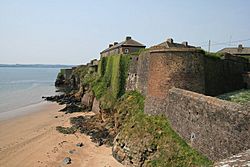
Duncannon Fort is a really old and important fort in County Wexford, Ireland. It's a special type of fort called a star fort because of its unique shape. Today, it's a National Monument, which means it's protected because of its long history.
Contents
Where is Duncannon Fort?
Duncannon Fort is built in a very important spot. It sits on a piece of land sticking out into Waterford Harbour. This location was perfect for controlling ships entering the harbour. The harbour leads to three big rivers in Ireland: the River Barrow, River Nore, and River Suir.
A Look at Duncannon Fort's History
Early Forts and Queen Elizabeth I
People have built forts here for a very long time. The Normans built a fort on this spot in the 1100s. There might have even been an older dirt fort built by the Gaelic Irish before that.
The fort you see today, the star fort, was built much later. It was built in 1587 and 1588 by Queen Elizabeth I. She wanted to protect the city of Waterford from a possible attack by the Spanish Armada.
Battles and Sieges
Duncannon Fort saw a lot of fighting during the Irish Confederate Wars. This was a big conflict in Ireland. In 1645, forces from the Irish Catholic Confederation attacked the fort. They were led by Thomas Preston, 1st Viscount Tara. The fort was defended by Laurence Esmonde, 1st Baron Esmonde. The attackers used mortars, which were a new type of weapon in Ireland at the time. The fort was captured after a long fight.
Later, in 1649, Oliver Cromwell tried to take Duncannon Fort, but he failed. However, the fort eventually gave up in 1650 after being surrounded by forces led by Henry Ireton.
Kings and a Lighthouse
In 1690, two kings visited Duncannon Fort! King James II sailed away from Duncannon on his way to France. The spot where his boat left is still called "King James' Hole." Later that year, King William III stayed at the fort. He was waiting for bad weather to clear before he could return to England.
A lighthouse was built at the fort in 1774. It's still used today to guide ships.
The 1798 Rebellion
During the 1798 Rebellion, Duncannon Fort was one of the few places in County Wexford that stayed under British control. The fort and the nearby town became a safe place for people who supported the British. It was also used to hold and punish rebels. This is why the fort is mentioned in the famous song "The Croppy Boy." A group of soldiers sent from the fort to defend Wexford town were defeated in a battle called the Battle of Three Rocks.
From Army Base to Museum
Duncannon Fort continued to be used by the British Army for many years. It was handed over to the Irish National Army in 1922. Sadly, it burned down during the Irish Civil War that same year.
For a while, the FCÁ (Ireland's Army Reserve) used the fort for summer camps. Then, in 1993, it was given to Wexford County Council. After that, it was opened as a museum, so people like you can visit and learn about its amazing history!
What Does Duncannon Fort Look Like?
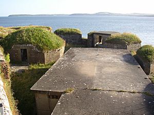
Duncannon Fort is a star fort, which means it has walls that stick out in points, like a star. This design helped defend against attacks from all sides. Along the sides of the fort, there were cannons facing both up and down the river. On the western end, there were big artillery batteries that could fire across the entire harbour entrance.
The parts of the fort facing the land had special defenses. There was an angled wall sticking out from the middle, a deep ditch, and an old medieval wall. There were also hidden passages called caponiers and counterscarp galleries. These allowed the soldiers inside to enter the ditch without being seen.
There's a nearby hill called Windmill Hill. People knew that an enemy could use this hill to attack the fort with cannons. So, in 1606, the English made the east wall of the fort taller to protect against this danger.
 | Claudette Colvin |
 | Myrlie Evers-Williams |
 | Alberta Odell Jones |


