
Netherlands Antilles facts for kids


The Netherlands Antilles was a special country made up of islands in the Caribbean Sea. It was part of the Kingdom of the Netherlands. This group originally had six islands. Some were found by Christopher Columbus in 1493, and others by Alonso de Ojeda in 1499.
Contents
Discovering the Islands: Where Are They?
The islands were split into two main groups.
Leeward Islands: Close to Venezuela
Aruba, Bonaire, and Curaçao are known as the Leeward Islands. They are located near the coast of Venezuela. These islands are famous for their sunny weather and beautiful beaches.
Windward Islands: Near Puerto Rico
Saint Martin, Sint Eustatius, and Saba are the Windward Islands. You can find them closer to Puerto Rico and the Virgin Islands.
Sint Maarten: An Island Divided
Interestingly, the island of Sint Maarten is shared. Its northern part belongs to France and is called Saint Martin. The southern part is Dutch and is known as Sint Maarten. So, one island, two countries!
The End of the Netherlands Antilles
Over time, the Netherlands Antilles changed.
Aruba's New Path
Aruba was the first island to leave the Netherlands Antilles. This happened in 1986. It became its own country within the Kingdom of the Netherlands.
Curaçao and Sint Maarten Become Countries
On 10 October 2010, Curaçao and Sint Maarten also became separate countries. They joined Aruba as independent countries within the Kingdom of the Netherlands. When this happened, the Netherlands Antilles as a country no longer existed.
The BES Islands: Part of the Netherlands
The remaining islands are Bonaire, Sint Eustatius, and Saba. They are often called the BES Islands. These islands now belong directly to the Netherlands. They are known today as the Dutch Caribbean islands.
Government and Leadership
Even though the Netherlands Antilles was a country, it was still part of the Kingdom of the Netherlands.
The Monarch's Role
This meant that the Dutch monarch was also the head of state for the Netherlands Antilles. For a long time, this was Queen Beatrix. Today, King Willem-Alexander is the monarch for Aruba, Curaçao, Sint Maarten, and the BES Islands.
Local Government
The islands had their own local government to manage their daily affairs. They made many of their own decisions.
Last Leaders of the Netherlands Antilles
The last Prime Minister of the Netherlands Antilles was Emily de Jongh-Elhage. The last Governor was Frits Goedgedrag. After the country ended in 2010, Frits Goedgedrag became the first Governor of Curaçao.
Images for kids
-
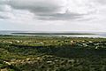
The flat landscape of Klein Bonaire
-
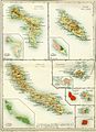
Maps of the Netherlands Antilles from the 1910s
-
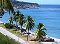
In the 18th century, Sint Eustatius was a very important Dutch island.
-
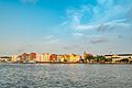
Willemstad, the capital city of Curaçao.
-
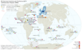
Map showing the European Union's overseas territories.
-
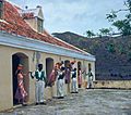
A Bulawaya dance in Curaçao.


.jpg)


See also
 In Spanish: Antillas Neerlandesas para niños
