England Creek, Queensland facts for kids
Quick facts for kids England CreekQueensland |
|||||||||||||||
|---|---|---|---|---|---|---|---|---|---|---|---|---|---|---|---|

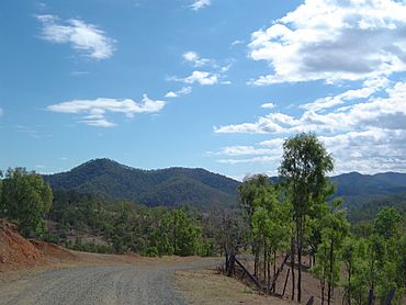
View north east from England Creek Road, 2014
|
|||||||||||||||
| Population | 39 (2021 census) | ||||||||||||||
| • Density | 0.671/km2 (1.74/sq mi) | ||||||||||||||
| Postcode(s) | 4306 | ||||||||||||||
| Area | 58.1 km2 (22.4 sq mi) | ||||||||||||||
| Time zone | AEST (UTC+10:00) | ||||||||||||||
| Location |
|
||||||||||||||
| LGA(s) |
|
||||||||||||||
| State electorate(s) |
|
||||||||||||||
| Federal Division(s) | |||||||||||||||
|
|||||||||||||||
England Creek is a quiet, countryside area in Queensland, Australia. It is split between two local government areas: the Somerset Region and the City of Brisbane. In 2021, only 39 people lived in England Creek.
Where is England Creek?
This locality is located a short distance southeast of Lake Wivenhoe, which is a large lake.
A creek, also named England Creek, flows through the area. This creek forms part of the eastern boundary before it joins the Brisbane River.
Important roads like the Brisbane Valley Highway and the Wivenhoe Somerset Road (State Route 31) pass to the southwest. The Mount Nebo Road (State Route 32) runs along the northeastern edge. The main road that goes through England Creek is England Creek Road.
A Bit of History
England Creek likely got its name from the creek that runs through the area.
Who Lives Here?
In 2021, England Creek had 39 people living there. A few years earlier, in 2016, there were 33 residents.
Schools for Kids
There aren't any schools right in England Creek. Kids living here usually go to primary schools in nearby areas. The closest government primary schools are Mount Nebo State School in Mount Nebo and Fernvale State School in Fernvale.
For high school, students might attend Lowood State High School in Lowood or Ferny Grove State High School in Ferny Grove. Both of these high schools are a bit further away.
 | Roy Wilkins |
 | John Lewis |
 | Linda Carol Brown |


