Esperance Plains facts for kids
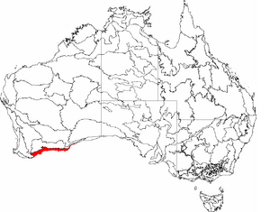
The Esperance Plains, also known as the Eyre Botanical District, is a special natural area in southern Western Australia. It's located along the south coast, between the Avon Wheatbelt and Hampton regions, and has the Mallee region to its north.
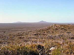
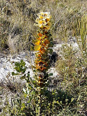
This area is mostly a flat plain, but it has cool granite and quartz rock formations and hills. The climate here is like a Mediterranean climate – warm and dry. Most of the plants are a mix of small, tough shrubs and heath plants, especially those from the Proteaceae family. Sadly, about half of this region has been cleared for farming.
The Esperance Plains is recognized as a bioregion under a system called the Interim Biogeographic Regionalisation for Australia (IBRA). It was first officially described by a scientist named John Stanley Beard in 1980.
Contents
Geography and Land Features
The Esperance Plains area is roughly the land within 40 kilometres (25 miles) of the coast. It stretches between Albany and Point Culver in Western Australia. This region covers about 29,000 square kilometres (11,000 square miles). That's about 9% of the whole South West Province.
To the north, it shares a border with the Mallee region. To the west, it meets the Jarrah Forest region. Not many people live here. The main towns you'll find are Bremer Bay, Ravensthorpe, Hopetoun, and Esperance.
The land here is mostly flat, rising from sea level to about 200 metres (700 feet) high. But in some spots, you'll see large granite domes and quartzite hills sticking out. The soil is made of old Eocene sediments. These sit on top of clay or ironstone gravel that comes from the Albany-Fraser Orogen, which is a very old rock formation.
Climate
The Esperance Plains has a warm, dry Mediterranean climate. This means it has about five to six dry months each year. Most of the rain falls in winter, usually between 500 and 700 millimetres (19–27 inches).
Here's a table showing the typical weather in Esperance, a town in this region:
| Jan | Feb | Mar | Apr | May | Jun | Jul | Aug | Sep | Oct | Nov | Dec | Year | ||
|---|---|---|---|---|---|---|---|---|---|---|---|---|---|---|
| Mean daily maximum temperature | 26.2°C 79.2°F |
26.2°C 79.2°F |
25.1°C 77.2°F |
23.2°C 73.8°F |
20.4°C 68.7°F |
18.0°C 64.4°F |
17.1°C 62.8°F |
17.7°C 63.8°F |
19.3°C 66.7°F |
21.0°C 69.8°F |
23.0°C 73.4°F |
24.5°C 76.1°F |
21.8°C 71.2°F |
|
| Mean daily minimum temperature | 15.5°C 59.9°F |
16.0°C 60.8°F |
15.0°C 59.0°F |
13.2°C 55.8°F |
11.0°C 51.8°F |
9.1°C 48.4°F |
8.3°C 46.9°F |
8.6°C 47.5°F |
9.5°C 49.1°F |
10.6°C 51.1°F |
12.6°C 54.7°F |
14.3°C 57.7°F |
12.0°C 53.6°F |
|
| Mean total rainfall | 21.7 mm 0.83 in |
27.3 mm 1.05 in |
28.8 mm 1.11 in |
42.7 mm 1.64 in |
74.2 mm 2.85 in |
81.1 mm 3.12 in |
99.6 mm 3.83 in |
84.1 mm 3.23 in |
59.9 mm 2.30 in |
48.4 mm 1.86 in |
34.7 mm 1.33 in |
18.1 mm 0.70 in |
620.6 mm 23.87 in |
|
| Mean number of rain days | 5.7 | 5.8 | 7.7 | 10.5 | 13.9 | 16.1 | 17.1 | 16.6 | 14.2 | 12.1 | 9.6 | 6.7 | 135.9 | |
| Source: Bureau of Meteorology | ||||||||||||||
Plant Life

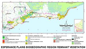
The main type of plant life in the Esperance Plains is called mallee-heath. This covers about 58% of the region. Other important plant types include mallee trees (17%), scrub-heath (13%), and coastal dune scrub (4%).
There aren't many large forests here. The only woodland areas have trees like Eucalyptus marginata (Jarrah), Corymbia calophylla (Marri), and E. wandoo (Wandoo). These are found in the valleys of the Stirling Range. You might also see E. loxophleba (York Gum) and Eucalyptus occidentalis (Flat-topped Yate) in lower, wetter areas. A small amount of low forest grows on islands off the coast. About 1.7% of the region has no plants at all.
As of 2007, scientists have found 3,506 different types of native plants with vascular systems (plants with tubes to carry water and nutrients) in the Esperance Plains. There are also 294 types of plants that are not native but have started growing wild here.
Sadly, 72 plant species in the Esperance Plains are endangered. This means they are at high risk of disappearing forever. Another 433 species are listed as "Priority Flora" by the Department of Environment and Conservation. This means they need special attention and protection.
How the Land is Used
About 87% of the Esperance Plains region is part of what the Department of Agriculture and Food calls the "Intensive Land-use Zone" (ILZ). This is an area in Western Australia where most of the land has been cleared for farming, like growing crops and raising animals. In this zone, about 45.4% of the original native plants are still left.
The other 13% of the region is in the "Extensive Land-use Zone" (ELZ). Here, the native plants haven't been cleared. However, they might have been affected by animals grazing or by changes in how often fires happen. Overall, about 47.3% of the entire Mallee region has been cleared.
Most of this clearing happened between 1949 and 1969. The Government of Western Australia had three main programs for this:
- The War Service Settlement program helped soldiers who had returned from war.
- The Civilian Settlement program was for other people who wanted to farm.
- The Esperance Land Development program was a partnership with an American company. This company developed almost 5,000 square kilometres (2,000 square miles) of land near Esperance to sell for farming.
Very little land has been cleared since 1980.
More than half of the remaining native plants are now in protected areas. Examples include the Fitzgerald River National Park and the Nuytsland Nature Reserve. Because of this, the region has a medium priority for protection under Australia's National Reserve System.
Understanding the Biogeography

Scientists have been studying and dividing Western Australia into different natural regions for a long time. In 1906, a scientist named Ludwig Diels created a region called "Eyre." This region was very similar to what we now call the Esperance Plains and Mallee regions combined.
Later, in 1926, Edward de Courcy Clarke suggested a new way to divide Western Australia. He proposed a region called "Stirling," which was very close to today's Esperance Plains region. In the 1940s and 1950s, Charles Gardner made Diels' regions more detailed, splitting the "Eyre" region into two parts.
In 1980, John Stanley Beard published his own way of dividing the state based on plant life. This new system included a district almost exactly like the Esperance Plains region we know today. Beard named it the "Eyre Botanical District" to honor Edward John Eyre, who was the first explorer of the area.
By 1984, Beard's plant-based regions were being called "natural regions" and given names that were easier for everyone to understand. So, the "Eyre Botanical District" became "Esperance Plains."
When the IBRA (Interim Biogeographic Regionalisation for Australia) system was created in the 1990s, Beard's work was used as the starting point for Western Australia. The Esperance Plains region was accepted as Beard had defined it. It has stayed the same through several updates to the IBRA system. Since Version 6.1, the Esperance Plains is divided into two smaller areas: Fitzgerald and Recherche.
The World Wildlife Fund also divides the Earth's land into "ecoregions." In their system, the Esperance Plains and Mallee regions are grouped together to form the Esperance mallee ecoregion.
See also
 In Spanish: Llanuras de Esperance para niños
 | Percy Lavon Julian |
 | Katherine Johnson |
 | George Washington Carver |
 | Annie Easley |


