Estacada, Oregon facts for kids
Quick facts for kids
Estacada, Oregon
|
|
|---|---|

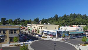
Downtown Estacada
|
|
| Motto(s):
Unexpected, Untamed, Unforgettable
|
|

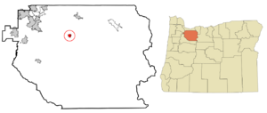
Location in Oregon
|
|
| Country | United States |
| State | Oregon |
| County | Clackamas |
| Incorporated | 1905 |
| Area | |
| • Total | 2.62 sq mi (6.79 km2) |
| • Land | 2.57 sq mi (6.65 km2) |
| • Water | 0.05 sq mi (0.14 km2) |
| Elevation | 499 ft (152 m) |
| Population
(2020)
|
|
| • Total | 4,356 |
| • Density | 1,695.60/sq mi (654.69/km2) |
| Time zone | UTC-8 (Pacific) |
| • Summer (DST) | UTC-7 (Pacific) |
| ZIP code |
97023
|
| Area code(s) | 503 |
| FIPS code | 41-23800 |
| GNIS feature ID | 2410457 |
| Website | www.cityofestacada.org |
Estacada is a city in Clackamas County, Oregon, United States. It is located about 30 miles (48 km) southeast of Portland. In 2020, about 4,356 people lived there.
Contents
History of Estacada
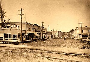
The Estacada post office opened in 1904. The city officially became a city in May 1905. It started as a camp for workers building a hydroelectric dam. This dam was on the nearby Clackamas River. It was built to provide electricity to Portland.
At first, it was hard to get to the river by road. So, the Oregon Power Railway Company built a railway. This railway helped transport workers to the dam construction site. After the Hotel Estacada was built, the town became a popular weekend spot. People from Portland would take the train to visit. During the week, the train carried supplies and workers.
After the dams were finished, Estacada became a center for the logging industry. In the early 1900s, a trolley line connected the town to downtown Portland. This railway line is no longer there. Today, there is no train service to Estacada.
How Estacada Got Its Name
The way Estacada got its name is a bit of a mystery. One idea is that the name came from two daughters, Esther and Katie. However, there is no proof that these daughters existed.
Another idea is that the name comes from a Spanish word. The word Estacado means "staked out" or "marked with stakes." George Kelly suggested this name in 1903. He picked it from a U.S. map that showed a place called Llano Estacado in Texas. If his idea hadn't been chosen, the town might have been called Rochester, Lowell, or Lynn! The name Estacada is also used in Arizona.
Geography of Estacada
Estacada covers about 2.06 square miles (5.34 square kilometers). Most of this area, about 2.01 square miles (5.21 square kilometers), is land. A small part, about 0.05 square miles (0.13 square kilometers), is water.
Outside the city, you'll find mostly farmland. This farmland stretches from the Springwater area to the south. It goes to Eagle Creek in the west. To the north and east, you'll find the Mount Hood National Forest.
Estacada's Climate
Estacada has a warm-summer Mediterranean climate. This means it has warm, dry summers and mild, wet winters.
| Climate data for Estacada, Oregon (1991–2020 normals, extremes 1909-present) | |||||||||||||
|---|---|---|---|---|---|---|---|---|---|---|---|---|---|
| Month | Jan | Feb | Mar | Apr | May | Jun | Jul | Aug | Sep | Oct | Nov | Dec | Year |
| Record high °F (°C) | 67 (19) |
72 (22) |
86 (30) |
94 (34) |
105 (41) |
117 (47) |
109 (43) |
105 (41) |
105 (41) |
92 (33) |
77 (25) |
68 (20) |
117 (47) |
| Mean maximum °F (°C) | 60.3 (15.7) |
63.5 (17.5) |
71.0 (21.7) |
79.0 (26.1) |
87.0 (30.6) |
90.9 (32.7) |
96.5 (35.8) |
96.6 (35.9) |
91.8 (33.2) |
79.1 (26.2) |
64.8 (18.2) |
60.3 (15.7) |
100.7 (38.2) |
| Mean daily maximum °F (°C) | 49.2 (9.6) |
52.6 (11.4) |
57.0 (13.9) |
61.8 (16.6) |
68.6 (20.3) |
73.3 (22.9) |
81.6 (27.6) |
82.5 (28.1) |
76.8 (24.9) |
64.7 (18.2) |
54.4 (12.4) |
48.3 (9.1) |
64.2 (17.9) |
| Daily mean °F (°C) | 42.1 (5.6) |
44.2 (6.8) |
47.5 (8.6) |
51.5 (10.8) |
57.4 (14.1) |
62.0 (16.7) |
68.0 (20.0) |
68.3 (20.2) |
63.5 (17.5) |
54.7 (12.6) |
46.7 (8.2) |
41.5 (5.3) |
54.0 (12.2) |
| Mean daily minimum °F (°C) | 35.0 (1.7) |
35.8 (2.1) |
38.1 (3.4) |
41.2 (5.1) |
46.3 (7.9) |
50.7 (10.4) |
54.3 (12.4) |
54.2 (12.3) |
50.3 (10.2) |
44.6 (7.0) |
39.1 (3.9) |
34.8 (1.6) |
43.7 (6.5) |
| Mean minimum °F (°C) | 25.4 (−3.7) |
26.6 (−3.0) |
29.3 (−1.5) |
32.7 (0.4) |
36.7 (2.6) |
42.9 (6.1) |
46.9 (8.3) |
46.7 (8.2) |
41.9 (5.5) |
33.9 (1.1) |
28.5 (−1.9) |
24.5 (−4.2) |
20.7 (−6.3) |
| Record low °F (°C) | −2 (−19) |
0 (−18) |
21 (−6) |
26 (−3) |
29 (−2) |
32 (0) |
36 (2) |
37 (3) |
30 (−1) |
22 (−6) |
8 (−13) |
−2 (−19) |
−2 (−19) |
| Average precipitation inches (mm) | 7.52 (191) |
5.93 (151) |
6.88 (175) |
5.45 (138) |
3.87 (98) |
2.58 (66) |
0.64 (16) |
0.76 (19) |
2.15 (55) |
5.51 (140) |
8.10 (206) |
8.38 (213) |
57.77 (1,468) |
| Average snowfall inches (cm) | 0.6 (1.5) |
0.4 (1.0) |
0.1 (0.25) |
0.0 (0.0) |
0.0 (0.0) |
0.0 (0.0) |
0.0 (0.0) |
0.0 (0.0) |
0.0 (0.0) |
0.0 (0.0) |
0.0 (0.0) |
0.0 (0.0) |
1.1 (2.75) |
| Average precipitation days (≥ 0.01 in) | 20.2 | 17.9 | 20.2 | 19.0 | 14.9 | 11.3 | 4.8 | 3.7 | 8.7 | 15.2 | 19.8 | 21.3 | 177.0 |
| Average snowy days (≥ 0.1 in) | 0.2 | 0.2 | 0.0 | 0.0 | 0.0 | 0.0 | 0.0 | 0.0 | 0.0 | 0.0 | 0.0 | 0.1 | 0.5 |
| Source: NOAA | |||||||||||||
People in Estacada
| Historical population | |||
|---|---|---|---|
| Census | Pop. | %± | |
| 1910 | 405 | — | |
| 1920 | 483 | 19.3% | |
| 1930 | 524 | 8.5% | |
| 1940 | 526 | 0.4% | |
| 1950 | 950 | 80.6% | |
| 1960 | 957 | 0.7% | |
| 1970 | 1,164 | 21.6% | |
| 1980 | 1,419 | 21.9% | |
| 1990 | 2,016 | 42.1% | |
| 2000 | 2,371 | 17.6% | |
| 2010 | 2,695 | 13.7% | |
| 2020 | 4,356 | 61.6% | |
| U.S. Decennial Census | |||
Estacada's Population in 2010
In 2010, there were 2,695 people living in Estacada. There were 1,062 households, which are groups of people living together. About 672 of these were families.
Most people in the city, about 92%, were White. About 7.5% of the population was Hispanic or Latino.
About 35% of households had children under 18 living with them. Nearly 44% were married couples living together. About 30% of all households were single people living alone. About 15% of households had someone 65 years or older living by themselves.
The average age in the city was about 35.7 years old. About 27% of residents were under 18. About 13% were 65 years or older. The number of males and females was almost equal.
Estacada's Economy
After the dams were built, the main way Estacada made money was through the lumber industry. This means cutting down trees and processing wood. As the timber industry has become less active, the city's economy has faced some challenges.
Arts and Culture in Estacada
The Estacada Public Library is a part of the Library Information Network of Clackamas County. This means it connects with other libraries in the area.
Estacada is also close to a well-known disc golf course. This course is at Milo McIver State Park. There are also disc golf courses at Timber Park and Metzler Park for players of all skill levels.
Education in Estacada
Students in Estacada go to schools in the Estacada School District. All these schools are located within the city limits.
The schools include:
- River Mill Elementary School
- Clackamas River Elementary School
- Estacada Middle School
- Estacada High School
Media in Estacada
The Estacada News is the local newspaper. It comes out once a week. The Pamplin Media Group owns and runs this newspaper.
Transportation in Estacada
Getting Around Estacada
Air Travel
- Valley View Airport is nearby for small planes.
Bus Services
TriMet's route 30 bus connects Estacada to the Clackamas Town Center mall. This mall has a transit center where you can catch the MAX Green Line light rail train. The bus route ends at Estacada City Hall.
On weekdays, the Sandy Area Metro bus service also runs from City Hall to Sandy. In Sandy, you can connect to buses that go to Gresham. From Gresham, you can connect to other TriMet lines and the MAX light rail.
See also
 In Spanish: Estacada para niños
 | William Lucy |
 | Charles Hayes |
 | Cleveland Robinson |


