
Fay Peak facts for kids
Quick facts for kids Fay Peak |
|
|---|---|

Fay Peak upper left, East Fay Peak centered.
|
|
| Highest point | |
| Elevation | 6,492 ft (1,979 m) |
| Prominence | 520 ft (160 m) |
| Isolation | 0.26 mi (0.42 km) |
| Parent peak | Old Desolate (7,137 ft) |
| Geography | |

Fay Peak
Location in Washington (state)

Fay Peak
Location in the United States
|
|
| Location | Mount Rainier National Park Pierce County, Washington, U.S. |
| Parent range | Cascades |
| Topo map | USGS Mowich Lake |
| Climbing | |
| First ascent | August 15, 1884 |
| Easiest route | class 2 scrambling west ridge |
Fay Peak is a mountain with two tops, called a double-summit. It is found in Mount Rainier National Park in Washington state. This mountain is part of the Cascade Range. It sits about 7 miles (11 km) northwest of Mount Rainier. The main top of Fay Peak is 6,492 feet (1,979 meters) high. East Fay Peak, which is a bit higher at 6,520 feet (1,987 meters), is a quarter-mile to the east. The closest taller mountain is Echo Rock, about 2.7 miles (4.3 km) away. Water from Fay Peak flows into Cataract Creek on the east side. On the west side, water goes into Mowich Lake and Mowich River.
Discovering Fay Peak: A Mountain's History
This mountain is named after Fay Fuller (1869–1958). She was the first woman to reach the top of Mount Rainier. Fay Fuller first climbed Mount Rainier on August 10, 1890. She climbed it again on July 27, 1897. The name Fay Peak first appeared on a map of the area in 1895. The United States Board on Geographic Names officially approved the name in 1913.
The very first time someone climbed Fay Peak was on August 15, 1884. This climb was made by J. Warner Fobes, George James, and R. O. Wells.
Weather Around Fay Peak: Understanding the Climate
Fay Peak is in a marine west coast climate zone. This means it has mild, wet winters and cool, dry summers. Most of the weather comes from the Pacific Ocean. These weather systems, called weather fronts, move northeast towards the Cascade Mountains.
When these fronts hit the tall Cascade Mountains, they are forced to rise. This process is called Orographic lift. As the air rises, it cools and drops its moisture. This causes a lot of rain or snowfall on the west side of the Cascades. Because of this, winters are very snowy. Summers often have clear skies due to high pressure systems over the Pacific Ocean. The best time to visit or climb Fay Peak is usually from July through September.
Images for kids
-
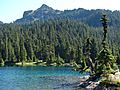
Fay Peak from Mowich Lake
-
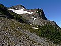
Fay Peak from Knapsack Pass
.JPG)

