Feather Peak facts for kids
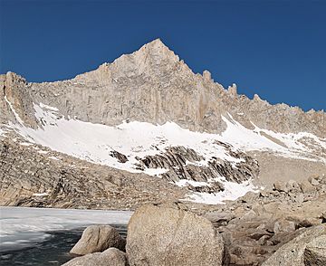
Quick facts for kids Feather Peak |
|
|---|---|

East aspect
|
|
| Highest point | |
| Elevation | 13,240 ft (4,040 m) |
| Prominence | 720 ft (220 m) |
| Isolation | 0.67 mi (1.08 km) |
| Parent peak | Royce Peak (13,280 ft) |
| Geography | |
| Location | Fresno County California, U.S. |
| Parent range | Sierra Nevada |
| Topo map | USGS Mount Hilgard |
| Geology | |
| Age of rock | Mesozoic |
| Type of rock | granite |
| Climbing | |
| First ascent | 1933 |
| Easiest route | class 3 south slope |
Feather Peak is a tall mountain in the Sierra Nevada range in northern California, United States. It stands at 13,240 feet (4,036 meters) high. You can find it in Fresno County, within the John Muir Wilderness. This area is looked after by the Sierra National Forest.
Feather Peak is located west of the Royce Lakes. It's about 0.66 miles northwest of Royce Peak, which is a slightly taller mountain nearby. Feather Peak is actually the 99th highest mountain in California! The very first time someone climbed to the top was in July 1933. This climb was done by David Brower, who also gave the peak its name.
Mountain Weather: What to Expect
Feather Peak is in an alpine climate zone. This means it has a cold, snowy, and windy environment, similar to what you'd find high up in mountains.
Most of the weather for this area comes from the Pacific Ocean. Big air masses, called weather fronts, travel east towards the Sierra Nevada mountains. When these fronts hit the tall peaks, they are forced to rise. As the air goes higher, it cools down and drops its moisture. This causes a lot of rain or snowfall on the mountains. This process is called orographic lift.
All the rain and snow that falls on Feather Peak eventually melts and flows away. This water drains south into smaller rivers that feed into the larger San Joaquin River.
Climbing Feather Peak
Feather Peak is a popular spot for climbers, with several established routes to the top. These routes vary in difficulty, from easier hikes to challenging rock climbs.
Here are some of the known climbing paths:
- Southeast Slope: This route was first climbed in 1933. It's rated class 3, which means it's a scramble where you might need to use your hands for balance, but it's not technical rock climbing.
- Southwest Ridge: This route is considered "class 4." This means it involves more difficult scrambling and might require ropes for safety, especially in exposed areas.
- Northeast Face: This is a much harder climb, rated class 5.9. It's a technical rock climb with 10 "pitches," which are sections of climbing between rest stops. It was first climbed in 1966.
- Feather Couloir (North Couloir): This route involves ice climbing, rated AI2. It has 4 pitches and is usually done in winter or spring when there's snow and ice.
- North Ridge: This route is rated class 5.4, which is a moderate technical rock climb. It was first climbed in 1992.
 | Janet Taylor Pickett |
 | Synthia Saint James |
 | Howardena Pindell |
 | Faith Ringgold |


