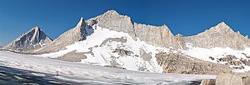
Royce Peak facts for kids
Quick facts for kids Royce Peak |
|
|---|---|

Northeast aspect (centered)
(Merriam Peak left, Feather Peak right) |
|
| Highest point | |
| Elevation | 13,280 ft (4,050 m) |
| Prominence | 880 ft (270 m) |
| Isolation | 3.45 mi (5.55 km) |
| Parent peak | Bear Creek Spire (13,726 ft) |
| Naming | |
| Etymology | Josiah Royce |
| Geography | |
| Location | Fresno County California, U.S. |
| Parent range | Sierra Nevada |
| Topo map | USGS Mount Hilgard |
| Type of rock | granite |
| Climbing | |
| Easiest route | class 2 south slope |
Royce Peak, also called Mount Royce, is a tall mountain in the Sierra Nevada range in northern California, United States. It stands 13,280 feet (4,048 meters) high! You can find it in Fresno County, inside the beautiful John Muir Wilderness. This area is looked after by the Sierra National Forest. Royce Peak is quite a neighbor, sitting close to Feather Peak and Merriam Peak. The closest taller mountain is Bear Creek Spire, a few miles north. Did you know Royce Peak is the 89th highest mountain in all of California? It was named in 1929 after Dr. Josiah Royce, who was a famous philosopher, teacher, and writer.
Mountain Weather and Climate
Royce Peak is located in an alpine climate zone. This means it has cold, snowy winters and cool summers. The weather here is mostly affected by air coming from the Pacific Ocean.
How Mountains Get Snow
Most weather fronts, which are like big air masses, start over the Pacific Ocean. They travel east towards the Sierra Nevada mountains. When these fronts hit the tall peaks, they are forced to rise. As the air goes up, it cools down. This cooling causes the moisture in the air to turn into rain or snowfall. This process is called orographic lift. All the rain and snow that falls on Royce Peak eventually flows into the San Joaquin River.
 | George Robert Carruthers |
 | Patricia Bath |
 | Jan Ernst Matzeliger |
 | Alexander Miles |


