Fingal, Tasmania facts for kids
Quick facts for kids FingalTasmania |
|||||||||||||||
|---|---|---|---|---|---|---|---|---|---|---|---|---|---|---|---|

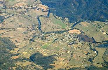
Aerial photo from south east. South Esk River visible.
|
|||||||||||||||
| Population | 431 (2021 census) | ||||||||||||||
| • Density | 79.6/km2 (206/sq mi) | ||||||||||||||
| Established | 1827 | ||||||||||||||
| Postcode(s) | 7214 | ||||||||||||||
| Elevation | 232 m (761 ft) | ||||||||||||||
| Area | 4.6 km2 (1.8 sq mi) | ||||||||||||||
| Location |
|
||||||||||||||
| LGA(s) | Break O'Day Council | ||||||||||||||
| Region | North-east | ||||||||||||||
| State electorate(s) | Lyons | ||||||||||||||
| Federal Division(s) | Lyons | ||||||||||||||
|
|||||||||||||||
Fingal is a small, quiet town located in the beautiful Fingal Valley in the north-east of Tasmania, Australia. It's part of the Break O'Day Council area. About 431 people lived here according to the 2021 census. It's about 56 kilometers (35 miles) south-west of the town of St Helens.
History of Fingal
Fingal was officially recognized as a place in 1965. The area around Fingal was first explored and mapped in 1824. This was done by two surveyors, Roderic O'Connor and John Helder Wedge.
It's believed that the town was named after Fingal's Cave in Scotland. It was not named after a place in Ireland.
The town of Fingal began in 1827 as a convict station. This was a place where convicts, who were prisoners sent from Britain, lived and worked. The town became very busy when the first valuable gold in Van Diemen's Land (which is now Tasmania) was found nearby. This gold discovery happened in a place called Mangana.
The Fingal Post Office, where people could send and receive mail, opened on June 1, 1832.
Geography of Fingal
Fingal is mostly surrounded by straight survey lines. The South Esk River flows through the area. It enters from the north and leaves towards the south-west.
Fingal's Climate
The weather in Fingal changes throughout the year. Here's a look at the temperatures and rainfall:
| Climate data for Fingal (Legge Street) (237 AMSL) | |||||||||||||
|---|---|---|---|---|---|---|---|---|---|---|---|---|---|
| Month | Jan | Feb | Mar | Apr | May | Jun | Jul | Aug | Sep | Oct | Nov | Dec | Year |
| Record high °C (°F) | 41.3 (106.3) |
36.4 (97.5) |
35.7 (96.3) |
29.4 (84.9) |
25.3 (77.5) |
20.7 (69.3) |
19.2 (66.6) |
22.2 (72.0) |
29.0 (84.2) |
31.6 (88.9) |
35.4 (95.7) |
39.3 (102.7) |
41.3 (106.3) |
| Mean daily maximum °C (°F) | 23.8 (74.8) |
22.9 (73.2) |
21.6 (70.9) |
18.4 (65.1) |
15.3 (59.5) |
12.7 (54.9) |
12.2 (54.0) |
13.3 (55.9) |
15.4 (59.7) |
17.6 (63.7) |
19.8 (67.6) |
21.7 (71.1) |
17.9 (64.2) |
| Mean daily minimum °C (°F) | 10.4 (50.7) |
10.1 (50.2) |
8.2 (46.8) |
5.3 (41.5) |
2.8 (37.0) |
1.1 (34.0) |
0.6 (33.1) |
1.2 (34.2) |
3.2 (37.8) |
4.9 (40.8) |
7.2 (45.0) |
8.8 (47.8) |
5.3 (41.5) |
| Record low °C (°F) | 0.1 (32.2) |
−0.2 (31.6) |
−1.9 (28.6) |
−4.8 (23.4) |
−8.1 (17.4) |
−9 (16) |
−8.1 (17.4) |
−7.4 (18.7) |
−6.2 (20.8) |
−4.6 (23.7) |
−2.1 (28.2) |
−1.5 (29.3) |
−9 (16) |
| Average rainfall mm (inches) | 44.5 (1.75) |
40.4 (1.59) |
45.0 (1.77) |
51.1 (2.01) |
50.7 (2.00) |
65.4 (2.57) |
54.9 (2.16) |
59.8 (2.35) |
49.8 (1.96) |
53.2 (2.09) |
46.0 (1.81) |
49.7 (1.96) |
608.3 (23.95) |
| Average rainy days (≥ 0.2 mm) | 7.2 | 6.5 | 7.9 | 8.3 | 9.6 | 10.8 | 12.0 | 11.4 | 10.8 | 10.8 | 9.4 | 8.7 | 113.4 |
| Source: Bureau of Meteorology | |||||||||||||
Getting Around Fingal
The main road that goes through Fingal is called Route A4, also known as Esk Main Road. It runs from the south-west part of the town to the north-east.
 | Jessica Watkins |
 | Robert Henry Lawrence Jr. |
 | Mae Jemison |
 | Sian Proctor |
 | Guion Bluford |


