
Firavitoba facts for kids
Quick facts for kids
Firavitoba
|
|||
|---|---|---|---|
|
Municipality and town
|
|||

Twilight over Firavitoba
|
|||
|
|||

Location of the municipality and town of Firavitoba in the Boyacá Department of Colombia
|
|||
| Country | |||
| Department | Boyacá Department | ||
| Province | Sugamuxi Province | ||
| Founded | There is no fixed date 1634 - 1781 | ||
| Area | |||
| • Total | 109.9 km2 (42.4 sq mi) | ||
| Elevation | 2,490 m (8,170 ft) | ||
| Population | |||
| • Total | 5,730 | ||
| • Density | 52.14/km2 (135.04/sq mi) | ||
| Time zone | UTC-5 (Colombia Standard Time) | ||
.svg)

Firavitoba is a town and a local government area (municipality) in Sugamuxi Province. This province is part of the Boyacá region in Colombia.
Long ago, before the Spanish arrived, Firavitoba was home to the Muisca Confederation. These were people from the Chibcha group. They lived in the highlands of the Eastern Andes mountains in Colombia. Firavitoba was part of the Iraca or Suamox state. This state had a special way of choosing its leader. Instead of passing power down in families, they elected their ruler. The leader was chosen from Firavitoba and Tobasá tribes, taking turns.
Firavitoba is famous for its beautiful church. It's built in a style called neo-Gothic, which looks like old European churches. This church, named Nuestra Señora de las Nieves (Our Lady of the Snows), is the third biggest in Colombia. It was built between 1873 and 1976. All the stone used to build it came from a nearby area called Pedregal in Sogamoso.
Contents
- What Does the Name Firavitoba Mean?
- Where is Firavitoba Located?
- A Look at Firavitoba's Past
- What Does Firavitoba Produce?
- Firavitoba's Airport
- Images for kids
- See also
What Does the Name Firavitoba Mean?
The name Firavitoba comes from the Muysccubun language. This was the language spoken by the Muisca people. Some say the name comes from two words: fiba, meaning "air", and faoa, meaning "clouds".
Where is Firavitoba Located?
Firavitoba is located on a high plateau called the Altiplano Cundiboyacense. It sits at an elevation of about 2,490 meters (8,170 feet) above sea level.
It shares borders with several other towns:
- To the north: Paipa and Tibasosa
- To the south: Iza and Pesca
- To the east: Sogamoso
- To the west: Tuta and Toca
The area of Firavitoba is about 109.9 square kilometers (42.4 square miles). Some parts are flat plains, and other parts are mountainous. The highest point is Guática hill, which is 3,228 meters (10,591 feet) high. The Chiquito River, which flows into the Chicamocha River, also runs through the area.
Firavitoba is about 77 kilometers (48 miles) from Tunja. Tunja is the capital city of the Boyacá region. It is also only about 10 kilometers (6 miles) from Sogamoso, the capital of its province.
A Look at Firavitoba's Past
Early History: Before the Spanish Arrived
The first people to live in this area might have been the Chibchan-speaking Arhuaco people. They lived near lakes. Later, the Muisca people, who also spoke Chibcha, arrived. They settled in the central highlands of the Colombian Andes. This area is known as the Altiplano Cundiboyacense.
The Muisca people came from the eastern plains of the Orinoquía region. Around the 11th or 12th century, they formed a powerful group called the Muisca Confederation. Their main center was in Hunza, which is now the city of Tunja.
About 70 years before the Spanish arrived, the Muisca territory was divided into four main states: Hunza, Bacatá, Tundama, and Iraca (also called Suamox, which is now Sogamoso). Each state had many tribes. These tribes shared culture, were close geographically, or had common defense needs. They all followed the same rules and had a leader.
Firavitoba was a tribe and a settlement within the Iraca state. The leader of this state was called the iraca or sogamuxi. Unlike other Muisca states, the iraca was not chosen by family inheritance. Instead, a council of leaders from four main tribes elected him. These tribes were Pesca, Toca, Gámeza, and Busbanzá. If they couldn't agree, the leader of the Tundama tribe would also vote. It was a tradition that the ruler had to be from Firavitoba or Tobasá, taking turns. This continued until the Spanish arrived.
Spanish Arrival and Colonization
In 1536, Spanish explorers led by Gonzalo Jiménez de Quesada began their journey. They wanted to find new lands and riches. Their expedition led them to the Muisca territory in the Andes mountains.
By 1537, the Spanish had explored much of the Muisca lands. They found areas rich in salt and emeralds. They took control of the Tunja zaque's treasures. Soon after, they conquered Suamox and killed the Bacatá zipa (leader). Many local leaders, including the leader of Firavitoba, faced harsh treatment during this time.
The New Kingdom of Granada
After the conquest, the Spanish established the New Kingdom of Granada. This new territory covered much of what is now Colombia. In 1549, a special court called the Royal Audiencia was set up in Santa Fé de Bogotá (now Bogotá).
In 1547, a Spanish soldier named Luis de Sanabria was given control over Firavitoba. This system was called an encomienda. It meant he was in charge of the local communities. Over the years, this responsibility passed down through his family.
Firavitoba was considered an "indigenous village" or a "religious district." A church was founded there in 1633.
The last encomendero of Firavitoba, Lorenzo de Rojas, gave a large estate to the Society of Jesus (Jesuits) in 1661. This estate was known as Hacienda La Compañía.
The Viceroyalty of New Granada
In 1717, the Spanish Crown created the independent Viceroyalty of New Granada. This large area included modern-day Colombia, Ecuador, Panama, and Venezuela. Bogotá became its main administrative center.
The first church in Firavitoba was destroyed, possibly by fire. It was rebuilt in 1718 and named Nuestra Señora de las Nieves.
The Jesuits stayed at the Hacienda La Compañia until 1767. That year, they were expelled from all Spanish territories. The estate was then divided and sold.
In 1781, Firavitoba gained a higher status as a "parish" (parroquia). This meant it had its own mayor and priest. The local people who had been under the encomienda system were moved. However, they were returned before a major uprising against the Spanish. This uprising was known as the Revolt of the Comuneros.
Independence and the 19th Century
After the revolt, Colombia declared its independence on July 20, 1810. However, Spain tried to regain control in 1815–1816. In Firavitoba, the local priest, Carlos Suarez, was jailed for speaking about freedom.
The fight for independence reached its peak in 1819. Key battles like Vargas Swamp (near Firavitoba) and Puente de Boyacá were fought. These battles led to the full independence of New Granada. This new country was called Gran Colombia. It later dissolved, and the region became the Republic of New Granada in 1831.
Even though schools were set up in Firavitoba, the town's importance decreased. Earthquakes in 1826 and 1827 badly damaged the church. But local leaders did little to fix it.
In 1869, a new priest, Father Ignacio Ramón Avella, arrived. He suggested building a grand new church. It would be based on a European design he had seen in Paris. The stone for the church would come from Sogamoso.
Construction began in 1873. Father Avella personally oversaw the work. Many residents of Firavitoba helped. They even crossed Lake Tota to get wood for the scaffolding.
The 20th Century: Building and Progress

The Grand Church of Nuestra Señora de las Nieves
Father Ignacio Ramón Avella passed away in 1901. The church was still being built, and the original plans were lost. Work slowed down until 1916. Then, Father Luis Abdénago Zambrano arrived. He ordered a new design, and construction continued.
By 1937, the church roof was finished. This protected the completed back and side walls. The front of the church (facade) was then built. The north tower was finished in 1946, and the south tower in 1949. This completed the outside of the church. Work then moved to the inside, with the main altar being installed.
Firavitoba's church was officially finished in 1976. This was over 100 years after construction began! The Archbishop of Tunja blessed the church. It is the third largest church in Colombia. It is built entirely of stone in the neo-Gothic style. It is a very important landmark for the town.
Other Important Events in the 20th Century
- Communication Improvements: The telegraph arrived in Firavitoba in 1919. Public telephones were connected in 1926.
- Utilities and Roads: Running water was connected to homes in 1929. The road to Sogamoso was finished in 1933. The road through Vargas Swamp to Paipa was completed in 1951.
- Electricity: In 1953, the Pro-Luz Company brought electric lighting to the town.
- Healthcare: In 1962, a new clinic began construction with support from the American government.
- Symbols of Firavitoba: On December 2, 1962, the town adopted its official flag and coat of arms. The flag is green with a diagonal stripe in the colors of the Colombian flag. The coat of arms shows the church, symbolizing the town. Wheat ears around the shield represent the fertile land and farming.
- Education: A secondary school program was introduced in 1963. The first students graduated in 1973.
- Infrastructure: A sewer system was built in 1965. In 1985, plans were made to pipe water from Lake Tota to the town.
- Local Government: The first mayoral election in Firavitoba was held in June 1988. Mayors are now elected every four years.
- Telecommunications: In 1989, land was given to the national phone company, Telecom. This was to build a local office and expand the telephone network.
- Earthquake Damage and Repair: On January 19, 1995, a strong earthquake hit the Boyacá region. Both towers of the church were badly damaged. Reconstruction began that year and lasted until 2000. The community helped raise money through festivals and contests.
Firavitoba in the 21st Century
- Road Improvements: In 2005, work began to pave the road from Firavitoba to Vargas Swamp. This road would connect to Paipa and shorten travel to Tunja. Also in 2005, a contract was signed to repair and improve the road connecting Firavitoba, Sogamoso, and Iza.
- New Library: In 2012, a new municipal library was built. It was opened on December 11, 2012. It has areas for adults and children, computers, and is accessible for people with disabilities.
- Park Renovation: In 2015, a park was renovated. It is on the site of Firavitoba's first Dominican church. The park honors Sister Gabriela de San Martín, who was born nearby.
- Street and Drainage Work: In 2017, repairs began on some of Firavitoba's streets. Four-lane road widening was completed. New drains were built to fix damage to the old sewage system.
What Does Firavitoba Produce?
The main way people make a living in Firavitoba is through livestock farming. They raise cattle for beef and dairy products.
Growing crops is the second most important part of the local economy. Farmers mainly grow potatoes, wheat, corn, beans, peas, and barley. Other vegetables are grown on a smaller scale.
In the mining sector, the main activity is limestone quarrying. This limestone is used to make cement.
Firavitoba's Airport
The small airport that serves Sogamoso is actually located within Firavitoba. It is called Alberto Lleras Camargo Airport (IATA-code: SOX).
Images for kids
-
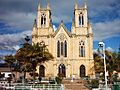
Nuestra Señora de las Nieves, Firavitoba
-
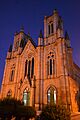
Nuestra Señora de las Nieves, Firavitoba
-
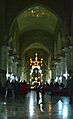
Interior, Nuestra Señora de las Nieves, Firavitoba
-
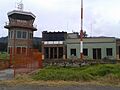
Airport "Alberto Lleras Camargo" of Sogamoso, located in Firavitoba


See also
 In Spanish: Firavitoba para niños
