Fishers Peak facts for kids
Quick facts for kids Fishers Peak |
|
|---|---|

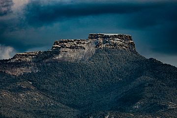
View of Fishers Peak from Trinidad, Colorado
|
|
| Highest point | |
| Elevation | 9,633 ft (2,936 m) |
| Prominence | 1,847 ft (563 m) |
| Isolation | 30.98 mi (49.86 km) |
| Listing | Colorado prominent summits Colorado range high points |
| Geography | |
| Location | Las Animas County, Colorado, United States |
| Parent range | Highest summit of Raton Mesas |
| Topo map | USGS 7.5' topographic map Fishers Peak, Colorado |
| Climbing | |
| Easiest route | hike |
Fishers Peak is a very tall and famous mountain in Colorado, United States. It's part of the Ratón Mesa range, which are like flat-topped mountains. Fishers Peak is the highest point of these mesas. It stands at 9,633-foot (2,936 m) tall! This makes it higher than any other place in the United States that is east of its location.
You can find Fishers Peak near the town of Trinidad in Las Animas County, Colorado. The Ratón Mesas stretch for about 90 miles. They start near the Sangre de Cristo Mountains (which are part of the Rocky Mountains) and go all the way to the Oklahoma border. Other mesas in this area include Black Mesa, Johnson Mesa, and Mesa de Maya.
Fishers Peak State Park: A New Adventure
In 2020, Colorado Parks and Wildlife created Fishers Peak State Park. A state park is a special area of land set aside for people to enjoy nature. This park covers 19,200-acre (7,800 ha) of land around Fishers Peak. Before it became a park, this huge area was a private ranch. The park officially opened in late October 2020.
Connected Nature Areas Around Fishers Peak
Right next to Fishers Peak State Park, there are more protected lands. These are called Colorado State Wildlife Areas (SWA). They include Lake Dorothey, which is 5,152 acres (2,085 ha), and James M. John, which is 8,339 acres (3,375 ha). These areas are important for protecting animals and plants.
Lake Dorothey also connects to Sugarite Canyon State Park in New Mexico. This park is 3,600 acres (1,500 ha). When you add up all these connected areas, there are about 36,000 acres (15,000 ha) of public land. This means a huge space for wildlife to live and for people to explore!
 | Jessica Watkins |
 | Robert Henry Lawrence Jr. |
 | Mae Jemison |
 | Sian Proctor |
 | Guion Bluford |


