
Floral City, Florida facts for kids
Quick facts for kids
Floral City
|
|
|---|---|

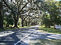
Picturesque East Orange Avenue in Floral City was once part of SR 48.
|
|

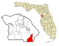
Location in Citrus County and the state of Florida
|
|
| Country | |
| State | |
| County | Citrus |
| Area | |
| • Total | 25.01 sq mi (64.77 km2) |
| • Land | 23.31 sq mi (60.38 km2) |
| • Water | 1.69 sq mi (4.39 km2) |
| Elevation | 62 ft (19 m) |
| Population
(2020)
|
|
| • Total | 5,261 |
| • Density | 225.68/sq mi (87.13/km2) |
| Time zone | UTC-5 (Eastern (EST)) |
| • Summer (DST) | UTC-4 (EDT) |
| ZIP code |
34436
|
| Area code(s) | 352 |
| FIPS code | 12-22775 |
| GNIS feature ID | 0282585 |
Floral City is a special community in Citrus County, Florida, United States. It's called a census-designated place (CDP), which means it's a community that isn't officially a city but is still counted for population.
In 2020, about 5,261 people lived in Floral City. This was a small increase from 5,217 people in 2010. Floral City is part of the larger Homosassa Springs, Florida area. The community is home to the Floral City Heritage Hall Museum. It also hosts the fun Floral City Heritage Days event every December. This area has a cool history, especially with phosphate mining, and many historic homes.
Contents
Geography of Floral City
Floral City is located in the southeastern part of Citrus County. It sits near the border with Hernando County. A main road, U.S. Route 41, runs right through the community.
You can drive north about 6 miles (10 km) to Inverness, which is the main town in Citrus County. If you drive south about 15 miles (24 km), you'll reach Brooksville.
The total area of Floral City is about 25 square miles (64.5 square kilometers). Most of this area, about 23.3 square miles (60.4 square kilometers), is land. The rest, about 1.6 square miles (4.1 square kilometers), is water. Floral City is at the southern end of Tsala Apopka Lake. This lake is part of the Withlacoochee River system.
The town is also located along the Withlacoochee State Trail. This trail is a long, paved path that follows an old railroad line. It's currently the longest paved trail in Florida, stretching about 46 miles (74 km).
History of Floral City

Floral City was planned and mapped out in 1883. This was done by a surveyor named W.H. Havron and Senator Austin S. Mann. The land originally belonged to James Baker. His father-in-law, John Paul Formy-Duval, was an early settler and landowner in the area.
At one point, Floral City was actually larger than Miami! This was because of the big phosphate mining industry in Citrus County. Phosphate is a mineral used in fertilizers. However, around the time of World War I, the mining in Floral City stopped. After the war, the mining moved south to the Bartow area, east of Tampa.
People say that Floral City still feels like a piece of "Old Florida." It has kept much of its original charm. The town got its name, Floral City, because of the many beautiful wild flowers that grow there. You can still see lots of them today!
Population Information
| Historical population | |||
|---|---|---|---|
| Census | Pop. | %± | |
| 1990 | 2,609 | — | |
| 2000 | 4,989 | 91.2% | |
| 2010 | 5,217 | 4.6% | |
| 2020 | 5,261 | 0.8% | |
| U.S. Decennial Census | |||
In 2000, there were 4,989 people living in Floral City. These people lived in 2,180 homes. About 20.4% of these homes had children under 18 living there. Many homes, about 56.7%, were married couples living together.
The average age of people in Floral City was 49 years old. About 20.3% of the population was under 18. About 29.2% of the population was 65 years old or older.
Education
Students in Floral City attend schools run by Citrus County Schools. The local schools include Floral City Elementary School, Inverness Middle School, and Citrus High School.
The Floral City Library, which is part of Citrus Libraries, is also located in Floral City.
Images for kids
-
Picturesque East Orange Avenue in Floral City was once part of SR 48.
-
Location in Citrus County and the state of Florida
-
An old rock wall in Floral City, Florida
See also
 In Spanish: Floral City para niños
