
Forbes Creek (Washington) facts for kids
Quick facts for kids Forbes Creek |
|
|---|---|

Aerial view of Kirkland with Forbes Creek watershed highlighted. North is up. Downtown Kirkland on Moss Bay is slightly left of center, Juanita Bay is at upper left. Forbes Lake is northeast of the I-405 cloverleaf.
|
|

Map showing the course of Forbes Creek, wetlands, and the approximate extent of its drainage area
|
|


Location of the mouth of Forbes Creek in Washington
|
|
| Country | United States |
| State | Washington |
| Region | King County |
| City | Kirkland, Washington |
| Physical characteristics | |
| Main source | 360 ft (110 m) 47°40′48.5″N 122°10′4″W / 47.680139°N 122.16778°W |
| River mouth | Juanita Bay Park Lake Washington 16 ft (4.9 m) 47°41′56″N 122°12′39″W / 47.69889°N 122.21083°W |
| Length | 2.5 mi (4.0 km) |
| Basin features | |
| Basin size | 6.6 sq mi (17 km2) |
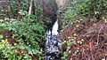
Forbes Creek is a small creek located entirely within the city of Kirkland, Washington. It flows about 2 miles (3.2 km) (3.2 km) from its start on Rose Hill to where it empties into Juanita Bay.
The creek's water comes from an area called a drainage basin. This basin stretches from NE 116th Street in the north to the Rose Hill ridgeline in the east. To the south, it reaches Kirkland's highest point, which is about 535 feet (163 m) (163 m) above sea level.
Forbes Creek has two main branches that begin on Rose Hill. One branch starts near Lake Washington High School and flows north towards Forbes Lake. The other branch begins near Rose Hill Elementary School and goes through North Rose Hill Woodlands Park. These two branches meet north of Forbes Lake. From there, the creek flows west under Interstate 405 and the Cross Kirkland Corridor. It then enters the Forbes Creek Valley and Juanita Bay Wetlands Park before finally flowing into Lake Washington at Juanita Bay.
Contents
Watershed and Wetlands
The Forbes Creek drainage basin covers about 1,837 acres (743 ha) (743 hectares). This is about a quarter of Kirkland's total land area. Forbes Creek is important because it empties into Lake Washington in the Juanita neighborhood.
There are 22 wetlands in the Forbes Creek basin. This is the largest number and area of wetlands of any creek in Kirkland. Wetlands are special areas where the land is covered by water, either all the time or for part of the year. They are very important for nature.
Plant Species in the Watershed
Some plants that are not native to the area, called invasive species, grow in Kirkland's watersheds. One example is the Himalayan blackberry. These plants can sometimes take over from native plants. You can also find European cranberry growing around Forbes Lake. It was likely planted there by people.
-
Invasive Himalayan blackberry and holly grow with native plants like salal and sword fern under alder and cedar trees.
-
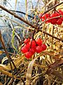
European cranberry plants on the shore of Forbes Lake.
-
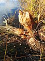
A tree in Forbes Lake Park that has been chewed by beavers.
-
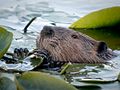
A beaver swimming among lily pads in Juanita Bay.
-
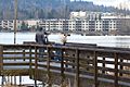
People watching birds at Juanita Bay Park, near Lake Washington.


.jpg)

How the Ice Age Created Forbes Creek
The way the land looks around Forbes Creek and the rest of the Eastside was shaped by the Ice Age. During this time, huge sheets of ice called glaciers moved across the land.
When the glaciers melted, they left behind hills of rock and dirt called moraines. They also created many small lakes and wetlands. The Forbes Creek watershed is a good example of this "unorganized" landscape left behind by the glaciers. It has bogs (wetlands) and creeks that flow down to the lake.
Forbes Lake
Forbes Lake is a 7 acres (2.8 ha) (2.8 hectare) lake. It is about 30 feet (9.1 m) (9.1 m) deep and sits 246 feet (75 m) (75 m) above sea level. It's a type of lake called a kettle lake, which forms when a block of ice melts after a glacier retreats.
The city of Kirkland is working on improving the areas around Forbes Lake. This includes a project to create the Forbes Lake Trail and Park, covering about 16 acres (6.5 ha) (6.5 hectares).
Wildlife at Forbes Lake
Many different animals live around Forbes Lake.
- In the lake, you can find frogs and turtles.
- Large birds like hawks and bald eagles use the tall trees around the lake for nests.
- Water birds such as ducks and great blue herons live in the lake and nearby wetlands.
- Mammals like beavers, deer, and coyotes also live in the area.

How Forbes Lake Got Its Name

Forbes Lake is named after the Forbes family, who were early settlers in the area. Dorr Forbes, a veteran of the Civil War, and his wife Eliza had a farm by the lake in 1877. They likely grew cranberries there. However, beavers caused problems for their farm, and the family eventually sold the land. This land later became the site of a steel mill.
The Forbes family also owned a shingle mill on Juanita Creek. They had a home on Juanita Bay that was built in the 1880s in Madison Park, Seattle. It was moved across Lake Washington by a barge or boat and rebuilt in 1905.
The Kirkland Steel Mill
Forbes Lake was once the planned site for the Kirkland Steel Mill. This mill was started by Peter Kirk, who founded the city of Kirkland. However, the mill never actually produced any steel. The project failed during a financial crisis known as the Panic of 1893.
Juanita Bay Park

The wetlands where Forbes Creek flows into Lake Washington are part of Juanita Bay Park. This is Kirkland's largest city park, covering about 110 acres (45 ha) (45 hectares).
Before 1830, a Duwamish village was located here. The Duwamish people harvested wapato tubers, which are edible plant roots, from the wetlands.
Wildlife at Juanita Bay Park
Juanita Bay Park is home to many animals, especially birds. Large numbers of birds live there all year or visit during winter. These include:
- Osprey
- Owls
- Bald eagles
- Herons
- Woodpeckers
Sometimes, as many as 1,600 birds have been counted in the park at once! Many mammals also live in the park, such as:
- Beavers
- Muskrats
- Nutria
- Raccoons
- River otters
- Weasels
- Coyotes
The Forbes Creek wetlands are known as great places for birdwatching. Organizations like The National Geographic Society and Reader's Digest have highlighted them. Many guidebooks for the Pacific Northwest also recommend them.
The Juanita Bridge was built in 1891 and rebuilt in 1932. It used to carry wagons and then cars across the wetland. In 1974, a new bridge was built nearby, and the old Juanita Bridge became a path just for people walking.
