Fort Edward, New York facts for kids
Quick facts for kids
Fort Edward
|
|
|---|---|

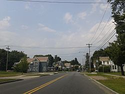
Houses at the edge of Fort Edward, near its border with Hudson Falls
|
|

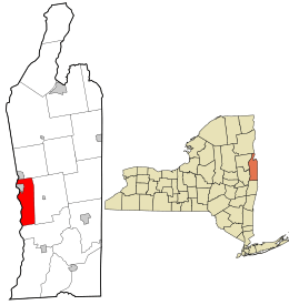
Location in Washington County and the state of New York.
|
|
| Country | United States |
| State | New York |
| County | Washington |
| Established | 1818 |
| Area | |
| • Total | 27.41 sq mi (70.99 km2) |
| • Land | 26.62 sq mi (68.93 km2) |
| • Water | 0.80 sq mi (2.06 km2) |
| Population
(2020)
|
|
| • Total | 5,991 |
| • Density | 218.57/sq mi (84.392/km2) |
| ZIP code |
12828
|
| Area code(s) | 518 |
| FIPS code | 36-115-26781 |
| Website | https://fortedward.net/ |
Fort Edward is a town in Washington County, New York, United States. It is also the county seat, which means it's where the main government offices for the county are located. In 2020, about 5,991 people lived here.
The town's main government buildings are found on U.S. Route 4. These offices moved to their current spot in 1994. Fort Edward is part of the larger Glens Falls Metropolitan Statistical Area. There is also a smaller area called Fort Edward village within the town. Both the town and the village are located on the western edge of Washington County.
Contents
History of Fort Edward
Early Days and Native American Paths
The area where Fort Edward is located was very important long ago. It was known as the "Great Carrying Place." This was a spot where people could carry their boats and goods around the waterfalls on the Hudson River. Native Americans used this path for thousands of years. It was also part of a major route called the "Great War Path." This path was later used by French and English settlers during their wars in the 1700s.
Building Fort Edward
During the French and Indian War (1754-1763), a fort was built here in 1755. General Phineas Lyman oversaw its construction, and it was first called Fort Lyman. Sadly, in the same year, Ephraim Williams was killed nearby. He was the person who started Williams College.
In 1756, the fort was renamed Fort Edward. This was done by Sir William Johnson, a British official who worked with Native American groups. He named it after Prince Edward. Prince Edward was the grandson of King George II and the younger brother of the future King George III.
Becoming a Town and Village
The town of Fort Edward was officially created in 1818. It was formed from parts of two other towns: Argyle and Greenwich. Later, in 1849, the community of Fort Edward became its own separate village. This meant it had its own local government.
Historic Places in Fort Edward
Several important buildings and places in Fort Edward are listed on the National Register of Historic Places. This means they are recognized for their historical value. Some of these include:
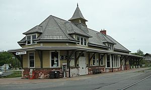
- Fort Edward D&H Train Station
- Fort Miller Reformed Church Complex
- St. James Episcopal Church
- Rogers Island
- Old Fort House
- Wing-Northup House
Famous People from Fort Edward
Fort Edward has been home to some notable individuals:
- Jane McCrea: She was taken from Fort Edward during the American Revolutionary War.
- Solomon Northup: He got married in Fort Edward and lived in the Old Fort House. His story was told in the book and movie 12 Years a Slave.
- Susan B. Anthony: This famous leader for women's rights taught school in a community called Moses Kill, New York.
Geography of Fort Edward
Fort Edward covers about 27.4 square miles (71.0 square kilometers). Most of this area is land, with a small part being water.
The western edge of the town is marked by the Hudson River. This river also forms the border with Saratoga County.
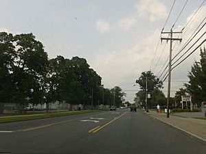
U.S. Route 4 runs along the Hudson River on the western side of the town. It meets New York Route 197 near Fort Edward village. The Hudson River also flows through the northern part of the town.
If you want to see where the original fort stood, you can find its site off Old Fort Street, just south of Route 4.
Population Information
| Historical population | |||
|---|---|---|---|
| Census | Pop. | %± | |
| 1820 | 1,631 | — | |
| 1830 | 1,816 | 11.3% | |
| 1840 | 1,726 | −5.0% | |
| 1850 | 2,328 | 34.9% | |
| 1860 | 3,544 | 52.2% | |
| 1870 | 5,125 | 44.6% | |
| 1880 | 4,680 | −8.7% | |
| 1890 | 4,424 | −5.5% | |
| 1900 | 5,216 | 17.9% | |
| 1910 | 5,740 | 10.0% | |
| 1920 | 5,845 | 1.8% | |
| 1930 | 5,841 | −0.1% | |
| 1940 | 5,716 | −2.1% | |
| 1950 | 6,213 | 8.7% | |
| 1960 | 6,523 | 5.0% | |
| 1970 | 6,719 | 3.0% | |
| 1980 | 6,479 | −3.6% | |
| 1990 | 6,330 | −2.3% | |
| 2000 | 5,888 | −7.0% | |
| 2010 | 6,371 | 8.2% | |
| 2020 | 5,991 | −6.0% | |
| U.S. Decennial Census | |||
In 2000, there were 5,892 people living in Fort Edward. The population density was about 220 people per square mile. The average age of people living in Fort Edward was 38 years old.
Train Travel
Amtrak is the national passenger train system in the United States. It offers train service to Fort Edward. The Adirondack train runs daily between Montreal (in Canada) and New York City. The Ethan Allen Express also runs daily between Burlington, Vermont, and New York City. The train stop is called Fort Edward-Glens Falls. It also serves nearby places like Hudson Falls and Fernwood.
Communities and Places in Fort Edward
The town of Fort Edward includes several smaller communities and interesting locations:
- Durkeetown – This is a small community, or hamlet, on the eastern border of the town. It is located east of Fort Edward village.
- Fort Edward – This is a village located in the northwestern part of the town.
- Fort Edward Center – This used to be a community about two miles (3 km) south of Fort Edward village.
- Fort Miller – A hamlet in the southern part of the town. It's on Galusha Island in the Hudson River and is home to Lock 6 on the Champlain Canal.
- Old Fort House – This is a museum that was added to the National Register of Historic Places in 1983.
- Moses Kill (also called "Mock") – This was a community along the Hudson River, south of Fort Edward village. It's named after a small stream that flows into the river there.
- Roger's Island – This island is in the Hudson River, right next to Fort Edward village. It was an important military site during the French and Indian War. From 1757 to 1763, it was the home base for Rogers' Rangers, a famous group of soldiers.
See also
 In Spanish: Fort Edward (Nueva York) para niños
 | Chris Smalls |
 | Fred Hampton |
 | Ralph Abernathy |


