Greenwich (town), New York facts for kids
Quick facts for kids
Greenwich
|
|
|---|---|

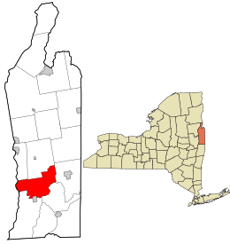
Location in Washington County and the state of New York.
|
|
| Country | United States |
| State | New York |
| County | Washington |
| Established | 1803 |
| Area | |
| • Total | 44.26 sq mi (114.64 km2) |
| • Land | 43.66 sq mi (113.09 km2) |
| • Water | 0.60 sq mi (1.55 km2) |
| Population
(2020)
|
|
| • Total | 4,868 |
| • Density | 109.986/sq mi (42.463/km2) |
| Time zone | UTC-5 (EST) |
| • Summer (DST) | UTC-4 |
| ZIP code(s) |
12834 (primary)
|
| Area code(s) | 518 |
| FIPS code | 36-115-30686 |
| Website | http://www.greenwichny.org/ |
Greenwich is a town in the southwestern part of Washington County, New York, United States. It is located on the western edge of the county. In 2020, about 4,868 people lived there.
Greenwich is part of the Glens Falls Metropolitan Statistical Area. The town is known for having several homes that were part of the Underground Railroad. This was a secret network that helped enslaved people find freedom. The Town of Greenwich also contains a village that is also called Greenwich.
Contents
History of Greenwich
The Horicon tribe is thought to be among the first native people in the area. Families started settling here around 1763. The land was originally divided into five large areas called land patents.
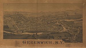
The Town of Greenwich was officially formed in 1803. It was created from a part of the Town of Argyle. In 1809, a community called Whipple City became a village and changed its name to Union Village. Later, in 1867, its name was changed again to Greenwich.
Greenwich played an important role in the Underground Railroad. This was a secret network of safe houses and routes. It helped enslaved African Americans escape to freedom in the North. A special marker in Mowry Park shows where these safe houses used to be.
In 1870, the Greenwich and Johnsonville Railroad brought train service to the area. This helped the town grow and connect with other places. A place called the Coffin Site was added to the National Register of Historic Places in 1980. This means it's an important historical location.
Geography of Greenwich
Greenwich covers about 44.4 square miles (114.9 square kilometers). Most of this area is land, with a small part being water.
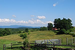
The town is located in the Cambridge valley region. This valley lies between the Adirondack Mountains and the Green Mountain Range in Vermont. The western border of the town is formed by the Hudson River. On the other side of the river is Saratoga County.
Two main highways pass through Greenwich. New York State Route 40 (NY 40) runs north and south through the middle of the town. NY 29 runs east and west near the southern town line. These two highways meet near Middle Falls.
Population of Greenwich
| Historical population | |||
|---|---|---|---|
| Census | Pop. | %± | |
| 1820 | 3,197 | — | |
| 1830 | 3,850 | 20.4% | |
| 1840 | 3,382 | −12.2% | |
| 1850 | 3,803 | 12.4% | |
| 1860 | 3,941 | 3.6% | |
| 1870 | 4,030 | 2.3% | |
| 1880 | 3,860 | −4.2% | |
| 1890 | 4,196 | 8.7% | |
| 1900 | 4,172 | −0.6% | |
| 1910 | 4,227 | 1.3% | |
| 1920 | 4,268 | 1.0% | |
| 1930 | 3,872 | −9.3% | |
| 1940 | 3,766 | −2.7% | |
| 1950 | 3,811 | 1.2% | |
| 1960 | 3,969 | 4.1% | |
| 1970 | 4,177 | 5.2% | |
| 1980 | 4,276 | 2.4% | |
| 1990 | 4,557 | 6.6% | |
| 2000 | 4,896 | 7.4% | |
| 2010 | 4,942 | 0.9% | |
| 2020 | 4,868 | −1.5% | |
| U.S. Decennial Census | |||

In 2000, there were 4,896 people living in Greenwich. There were 1,927 households, with many being families. The average household had about 2.54 people.
The population included people of all ages. About 25.9% were under 18 years old. The median age was 39 years. This means half the people were younger than 39 and half were older.
Education in Greenwich
Most of Greenwich is part of the Greenwich Central School District. This district has three school buildings. It serves about 1,300 students. The district also employs 99 administrators and teachers.
The school district was created in 1945. It combined several smaller rural school districts. It also included the school district in Greenwich village. Some small parts of Greenwich are in other school districts. These include Schuylerville, Argyle, and Salem Central school districts.
The Adirondack School of Northeastern New York offers private education. It serves students in grades 7 through 12.
Notable People from Greenwich
Many interesting people have connections to Greenwich:
- Susan B. Anthony – A famous civil rights activist who spent her childhood here.
- Chester A. Arthur – Lived in Greenwich for five years when he was young. He later became the 21st President of the United States.
- John Lourie Beveridge – Born in Greenwich in 1824. He was a general in the Civil War. He later became the 16th Governor of Illinois.
- George Henry Corliss – The inventor of the Corliss steam engine. He grew up in Greenwich.
- Kim Gannon – A lawyer who became a lyricist. He co-wrote the famous holiday song "I'll Be Home for Christmas." He is buried in Greenwich.
- Hal Ketchum – A country music star and member of the Grand Ole Opry. He was born in Greenwich.
- Grandma Moses – A well-known American folk artist. She was born on a farm in the nearby Town of Easton.
- Phantogram (band) – An electronic music duo that formed in Greenwich.
Communities and Locations in Greenwich
Greenwich has several smaller communities and interesting places:
Communities and Inhabited Locations
- Bald Mountain – A small community west of a mountain with the same name. It was once a mining town but is now known for farming.
- Battenville – A community on the southern town line, located by the Batten Kill river.
- Cossayuna – A community south of Cossayuna Lake. It was settled in 1765 and was an early trading center. It was first known as Hog Hollow.
- Center Falls – A community east of Greenwich village. It is on NY 29 by the Batten Kill river.
- Clarks Mills – A community in the southwestern corner of the town. It is also by the Batten Kill river.
- East Greenwich – The oldest community in the town. It is in the southeastern part of the town along the Batten Kill. It used to be called Slab City.
- Greenwich – A village located at the southern town line and the Batten Kill. Part of the village is in Greenwich, and part is in the town of Easton.
- Middle Falls – A community west of Greenwich village on NY 29. It is named after a 45-foot (14 meter) natural waterfall on the Batten Kill.
- North Greenwich – A community near the northern town line. It was an important early stop for stagecoaches traveling between Albany and Whitehall.
- Thomson – A community northwest of Clarks Mills, by the Hudson River. It was once known for sawmills and now for paper mills.
Geographical Features
- Batten Kill – A river that forms the southern border of the town.
- Cossayuna Lake – A lake on the northern town line. Only a small part of the lake is in Greenwich.
- Hartshorn Brook – A small stream that flows into the Batten Kill.
- McDougall Lake – A small lake that is also partly in the town of Salem.
- Slocum Creek – A small stream that flows into the Hudson River.
See also
 In Spanish: Greenwich (Nueva York) para niños
 | May Edward Chinn |
 | Rebecca Cole |
 | Alexa Canady |
 | Dorothy Lavinia Brown |


