Fossil Mountain (Grand Canyon) facts for kids
Quick facts for kids Fossil Mountain(Grand Canyon) |
|
|---|---|

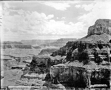
(Havasupai Point, next to Fossil Mountain)
|
|
| Highest point | |
| Elevation | 6,729 ft (2,051 m) |
| Prominence | 309 ft (94 m) |
| Isolation | 0.61 mi (0.98 km) |
| Parent peak | Havasupai Point (6,820 ft) |
| Geography | |
| Location | Grand Canyon National Park Coconino County, Arizona, US |
| Parent range | Coconino Plateau Colorado Plateau |
| Topo map | USGS Explorers Monument |
| Geology | |
| Type of rock | The most common top 4 rock layers in the Grand Canyon: and Kaibab Limestone (a strong cliff rock), Toroweap Formation, Coconino Sandstone (a thick cliff rock), Hermit Formation (a softer shale rock) |
Fossil Mountain is a mountain in the western part of the Grand Canyon. It is located in Coconino County, in northern Arizona, USA. This mountain stands 6,729 feet (2,051 meters) tall.
Fossil Mountain is about 1.5 miles east of Mount Huethawali. It is also about 1.0 mile southeast of the Grand Scenic Divide. You can find it 1.0 mile west of Havasupai Point. The top part of Fossil Mountain is a large cliff made of Kaibab Limestone. This cliff rises above a flat, forested area called a plateau. This plateau is part of the South Rim of the Grand Canyon.
Contents
What is Fossil Mountain Made Of?
Fossil Mountain is mostly made of different kinds of sedimentary rock. These are rocks formed from layers of sediment over millions of years. The main types of rock found here include limestone, sandstone, siltstone, mudstone, and shale.
The Kaibab Limestone Layer
The very top part of Fossil Mountain is a large cliff of Kaibab Limestone. This rock layer is about 350 feet thick. It is a very strong type of rock that forms tall, steep cliffs. The Kaibab Limestone is known for having many fossils, which is how Fossil Mountain got its name!
Layers Below the Top
Below the Kaibab Limestone cliff, you will find other rock layers.
- Toroweap Formation: This layer is about 250 feet thick. It is made of softer rocks that form slopes, not steep cliffs. Trees and other plants often grow on these slopes.
- Coconino Sandstone: Underneath the Toroweap Formation is a thick layer of Coconino Sandstone. This layer is about 500 feet thick. It forms very straight, tall cliffs, especially on the northeast side of Fossil Mountain. This sandstone is very strong and has not worn away much.
- Hermit Formation: The Coconino Sandstone sits on top of large slopes of Hermit Formation. This layer is made of softer shale rock. Like the Toroweap Formation, it often has a lot of plants growing on it.
Images for kids
 | Toni Morrison |
 | Barack Obama |
 | Martin Luther King Jr. |
 | Ralph Bunche |


