
Frame Lake facts for kids
Quick facts for kids Frame Lake |
|
|---|---|

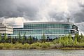
Lake in summer 2005
|
|

Frame Lake
Location in Northwest Territories
|
|
| Location | Yellowknife, Northwest Territories, Canada |
| Coordinates | 62°27′14″N 114°23′24″W / 62.454°N 114.390°W |
| Type | Endorheic |
| Etymology | Bill Frame, early miner and businessman |
| Primary inflows | Two unnamed local streams |
| Primary outflows | Seepage |
| Surface area | 84 hectares (210 acres) |
| Max. depth | 6.5 metres (21 ft) |
| Surface elevation | 186 metres (610 ft) |
| Frozen | Winter |
| Islands | 5 |
| Settlements | Yellowknife |
Frame Lake is a freshwater lake in Yellowknife, Northwest Territories, Canada. It covers about 84 hectares (210 acres) (208 acres). The lake is special because it is an endorheic lake. This means water flows into it but does not flow out to other rivers or lakes.
Frame Lake is located between Yellowknife's downtown and a large residential area. The Frame Lake Trail goes all the way around it. Important buildings like the city hall and the territorial government building are right on its shores.
This lake formed about 20,000 years ago from melting glaciers. It has always been important to the history of Yellowknife. The Dene people used it for fishing long before Europeans arrived. As the city grew, nearby gold mines sometimes dumped waste into the lake. Later, it became a popular spot for swimming and boating.
However, things changed. Storm sewers started taking away much of the natural water that fed the lake. Also, the lake's only natural outflow was blocked. This made pollution problems worse. By the early 1970s, no fish could live in the lake. Within 20 years, people stopped swimming or boating there because of leeches. Studies later showed the lake became completely eutrophied (too many nutrients, not enough oxygen) by the mid-1990s.
Some people in Yellowknife want to clean up the lake. They hope it can become a place for swimming, fishing, and boating again. To do this, the water needs more oxygen so fish can return. This could happen by adding air to the water or by dredging. Dredging means removing the rotten material from the lake bottom. This material currently makes the water lack oxygen when the lake freezes in winter.
Contents
Exploring Frame Lake's Geography
Frame Lake has an irregular shape. It has a northern and a southern part, connected by a narrower middle section. A wide peninsula sticks out from the western shore. An arm of the lake also extends to the east. The lake is about 1.4 kilometres (0.87 mi) (0.9 miles) long.
The lake sits at an elevation of 186 metres (610 ft) (610 feet). The land around it is gently rolling, with some small hills. Five small islands are in the lake, three in the north and two in the south. Two small streams flow into the lake from the west. One comes from ditches near the Yellowknife Airport. The other flows from Range Lake.

The land around the lake is mostly taiga forest. You can also see bare rock outcrops from the Canadian Shield. The shoreline is mostly bare rock, but some shallow bays have weed beds. On the eastern shore, there is a sandy area called McNiven Beach. It is named after Yellowknife's first mayor.
The city of Yellowknife forms a "V" shape around the lake. On the eastern side is New Town, which is the city's modern downtown. Public buildings like City Hall and the Royal Canadian Mounted Police headquarters are along the lake's eastern arm. Their lawns almost reach the water.
South of City Hall is Somba K'e Park. This is an open green space with a well-developed shoreline. Beyond this park, the forest and rock act as a buffer between the lake and the city. The Frame Lake Trail, a 5.5 kilometres (3.4 mi) (3.4 miles) path, follows the shoreline closely. Near McNiven Beach, there is a recreation center with an arena and pool.
At the south end, another neighborhood is close to the lake. The Stanton Regional Hospital is also nearby. Old Airport Road runs along part of the lake's southwestern shore. The northwestern side and northern end of the lake are mostly forest and rock.
On the northeastern side of the lake, you'll find two other important public buildings. These are the Prince of Wales Northern Heritage Centre (the territorial museum) and the Northwest Territories Legislative Building. A causeway carries the Frame Lake Trail across an arm of the lake. The Northern Frontier Visitor Centre is also located here, overlooking the lake.
Frame Lake's History
Frame Lake was formed when glaciers melted after the last Ice Age. For a long time, it stayed a very clean lake. But when people settled nearby, things changed. The lake's only outlet closed around 1970. This quickly led to its decline and eutrophication. By the end of the 1900s, fish could no longer live there. People stopped using it for fun activities. Efforts to help the lake began in the 2010s.
Before Yellowknife: Early History (Prehistory–1934)
Like many lakes in the Northwest Territories, Frame Lake was created by glaciers. During the last Ice Age, about 20,000 years ago, huge glaciers covered most of Western Canada. As they melted, they left behind large lakes of meltwater. Frame Lake was one of these smaller lakes. Fine sand settled in low areas, forming the lake bed.
People started using the lake about 7,500 years ago. The Dene people, who are the First Nations of the region, found many fish in the lake. These included pike, suckers, and whitefish. They had a fishing camp near the lake.
Yellowknife's Growth and Lake Decline (1934–1992)
European settlers came to the area in the early 1900s. They first used the lake as a base for bush pilots. These pilots flew to mining camps further north. In the mid-1930s, a lot of gold was found. This led to Yellowknife becoming a permanent settlement. Early gold mines sometimes dumped waste and sewage into Frame Lake. The lake was named after Bill Frame, an early miner and businessman.
Yellowknife grew quickly after World War II. The higher ground near Frame Lake was chosen for new development. The area east of the lake became New Town, which is now downtown. McNiven Beach was set up for swimming. Sometimes, floatplanes even landed on the lake. People also enjoyed boating.
Over time, storm runoff carried more and more nutrients into the lake. In winter, the city even dumped plowed snow into the lake, adding more nutrients. Sewage from nearby Niven Lake might have also flowed into Frame Lake.

By the early 1970s, people noticed the lake was changing. A study later found that building a causeway across the lake's eastern arm in 1970 was a "tipping point." This causeway blocked the lake's only outlet. Without water flowing out, nutrient levels in the water rose. This caused many aquatic plants to grow in summer. In winter, when the lake froze and snow blocked sunlight, these plants died. Their decomposed remains built up on the lake bottom, removing oxygen from the water.
In 1973, a study of seven lakes in Yellowknife found no fish in Frame Lake. It was the only lake where this happened. The study also noted that the lake quickly became anoxic (without oxygen) in winter.
As the lake declined, more buildings came closer. Yellowknife's city hall was built by the lake in 1975. The Prince of Wales Northern Heritage Centre followed four years later. By the late 1970s, fewer people swam at McNiven Beach. The city removed the swimming facilities.
People still swam and boated in the early 1980s, but in smaller numbers. Some were scared by reports of leeches. As the city grew, new homes and businesses were built near the lake. Storm sewers for these projects diverted runoff that used to feed the lake. This made the remaining water even more concentrated with nutrients.
Efforts to Restore the Lake (1993–Present)
The Northwest Territories Legislative Assembly moved into its new building on the north shore of the lake in 1993. By then, people had stopped using the lake for recreation. Many residents were afraid of leeches, which thrived because there were no fish to eat them. Instead, the lake became the focus of the 5.5 kilometres (3.4 mi) (3.4 miles) Frame Lake Trail. This path around the lake became popular for walking and jogging.
In 2007, a report suggested protecting Frame Lake with special zoning laws. In the following years, people started to care more about the lake. Some newer residents were surprised to hear that people used to swim and sail there. In 2013, a local resident organized a cleanup and swim in the lake on Canada Day.
A 2015 study helped explain how the lake had declined since 1970. Researchers continue to study the lake to find the best ways to restore it. They believe that removing rotten sediments from the lake bottom or adding air to the water would help improve its quality.
Understanding Frame Lake's Geology
Frame Lake sits on a mix of volcanic and plutonic igneous rock. Most of it is basalt rock, which is common in the Yellowknife area. There are also areas of granite and granodiorite.
Two faults (cracks in the Earth's crust) run across the south end of the lake. One fault runs under the stream from Robinson's Pond and across to McNiven Beach. The larger Kam Fault is at the very south end. When it was active, it could cause earthquakes.
You can also see signs of the lake's glacial past. On the east shore, rocks have scratches from the moving glaciers. The fine sand on the lake bed is also left over from the glaciers. In some places around the lake, the ground has permafrost (permanently frozen ground) about 15 metres (49 ft) (49 feet) deep.

Where there is soil around the lake, it is mostly silt and clay. This type of soil does not support buildings very well. Also, the bedrock underneath is not at a consistent depth. This caused problems when buildings like the military headquarters and visitor's center were constructed.
Water Quality Studies
Frame Lake has been studied twice in detail. Once in the early 1970s, scientists looked at its water. More recently, in the 2010s, researchers examined the sediments to understand how the lake had changed.
In the early 1970s, researchers studied Frame Lake and six other lakes near Yellowknife. They wanted to see if Frame Lake could be used for an experimental fishery. Their study in 1973 showed that while Frame Lake's water quality was still good enough for recreation, there were already signs of decline.
The water had high levels of salts and bicarbonates. It was generally the same temperature throughout, but the deeper parts cooled in August. There was still plenty of oxygen in the water. The researchers thought the high oxygen demand and unusual water chemistry were due to the nearby city and the dumping of plowed snow into the lake.
They found no fish in Frame Lake, which was unusual compared to the other lakes. However, Frame Lake had the highest amount of living material (biomass) on its bed. This was more than three times higher than the next highest lake.
In the 2010s, new studies looked at the lake's sediments. They found that between the late 1940s and 1970, half a meter (50 centimetres (20 in)) of sediment built up on the lake bottom. This was more than any other lake in the region. The 10 centimetres (3.9 in) of sediment from after the causeway was built was black and smelled of sulfur. It also had very high levels of metals, especially arsenic. These findings match old descriptions of smelly, gooey patches on the lake bottom.
Images for kids
-
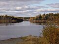
Lake in summer 2005
-
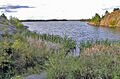
Weeds and exposed rock on the shoreline
-
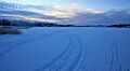
The lake freezes over in the winter, limiting light available for photosynthesis.
-
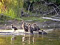
Ducks on the lakeshore, 2011
-
Bedrock below the military headquarters building is not at a uniform depth.

