Franconia, Virginia facts for kids
Quick facts for kids
Franconia, Virginia
|
|
|---|---|

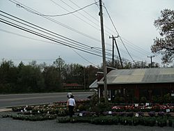
Nall's Produce in Franconia
|
|

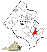
Location of Franconia in Fairfax County, Virginia
|
|
| Country | United States |
| State | Virginia |
| County | Fairfax |
| Area | |
| • Total | 3.48 sq mi (9.01 km2) |
| • Land | 3.47 sq mi (8.99 km2) |
| • Water | 0.008 sq mi (0.02 km2) |
| Elevation | 249 ft (76 m) |
| Population
(2020)
|
|
| • Total | 18,943 |
| • Density | 5,459.1/sq mi (2,107.1/km2) |
| Time zone | UTC−5 (Eastern (EST)) |
| • Summer (DST) | UTC−4 (EDT) |
| ZIP Codes |
22310, 22315
|
| Area code(s) | 703, 571 |
| FIPS code | 51-29552 |
| GNIS feature ID | 1492975 |
Franconia is a community located in Fairfax County, Virginia, in the United States. It is known as a census-designated place (CDP), which means it's an area identified by the U.S. Census Bureau for statistical purposes. In 2020, about 18,943 people lived there.
This community is just southwest of Alexandria. Franconia started as a small community in the 1870s. This was when a train station opened there on the RF&P Railroad. However, Franconia really began to grow into the suburban area we see today in the 1950s. The area includes neighborhoods like Manchester Lakes and Windsor Estates. Even though it's Franconia, many street addresses use Alexandria ZIP Codes 22310 and 22315. It is also close to the Springfield Mall and the Franconia–Springfield Washington Metro station.
Contents
Exploring Franconia's Location
Franconia is in the southeastern part of Fairfax County. It is about 13 miles (21 km) southwest of Washington, D.C..
- To the west, Franconia borders Springfield.
- To the north, it is next to Lincolnia.
- To the northeast, you'll find Rose Hill.
- To the east, it touches Kingstowne.
- To the south, it borders Newington.
The United States Census Bureau says that Franconia covers a total area of about 3.5 square miles (9.0 square kilometers). Only a tiny part of this area, about 0.008 square miles (0.02 square kilometers), is water.
Franconia's Past: A Look at History
Franconia has a rich history, from its early days as a tobacco route to its role in the Civil War.
Early Days and the Railroad
Long ago, Franconia Road was a "rolling road." This meant it was used to roll large barrels of tobacco to the port in Alexandria. The community got its name from a farm called "Frankhonia Farm." This farm was bought in 1859 by William Fowle, a merchant from Alexandria.
In 1871, William Fowle's son, Robert Rollins Fowle, sold 18 acres of land to a railway company. This land was used to build a railway station, which was also named Franconia after the farm. The station was very important for the community. It even had a post office called Garfield Post Office for many years.
After a fire in 1903, the station was moved. It continued to serve the community until about 1953. Today, a historic marker stands in front of the Franconia Governmental Center. This marker remembers the old railway station. For a long time, the center of the community was Wards Corner. This was a busy spot with a gas station, grocery store, bar, movie theater, and dance hall. Sadly, a fire in 1959 destroyed everything there.
Franconia During the Civil War
In January 1862, during the American Civil War, a small fight happened in the Franconia area. Colonel Wade Hampton III and his cavalry (soldiers on horseback) met some Union cavalry. They chased them, but a scout warned Hampton about an ambush. Hampton stopped his men on Potter's Hill. Both sides then started shooting, and some soldiers were hurt. The Confederates then left the area.
Potter's Hill later became the site of three schoolhouses. The last one burned down in 1932. More recently, it was a chicken farm and then a gravel quarry. This quarry provided materials to build the first Woodrow Wilson Bridge. Today, the Hilltop Village Center stands where Potter's Hill once was.
Community Services and Landmarks
The Franconia Volunteer Fire Department was started in 1934. Their first firehouse was built in 1937. Today, the department still helps the community from two locations.
Franconia is also home to the Laurel Grove Colored School and Church. This was started by former slaves in the 1880s. The land for the school was given in 1881. The school served the community until 1932. In 1884, more land was given for a church to be built next to the school. Laurel Grove Baptist Church was destroyed by a fire in 2004. However, the church cemetery and the old school building still exist. The school building was honored with a historical marker in 2008.
Other churches have also been part of the neighborhood. These include Sharon Chapel, founded in 1848, and Olivet Episcopal Church. Next to Sharon Chapel is a cemetery. Other cemeteries can be found along Beulah Street.
The history of Franconia is kept and shared by the Franconia Museum. It is located in the Franconia Governmental Center.
People of Franconia
Franconia is a diverse community with people from many different backgrounds.
Population Overview
According to the 2020 census, there were 18,943 people living in Franconia. The community has a mix of different races and ethnicities. About 45% of the people were White, 20% were African American, and 16% were Asian. About 13% of the population identified as Hispanic or Latino.
Many households in Franconia are families. The average family household had about three people. The median age in Franconia was 40.4 years old. About 17.8% of the people were under 18, and 13.7% were 65 or older. Many people in Franconia speak a language other than English at home. Also, a good number of residents were born outside the United States.
The median income for a household in Franconia was about $143,322. This means that half the households earned more than this amount, and half earned less. Many adults in Franconia have a college degree or higher. A small percentage of the population lives below the poverty line.
See also
 In Spanish: Franconia (Virginia) para niños
 | Bayard Rustin |
 | Jeannette Carter |
 | Jeremiah A. Brown |


