Gairich facts for kids
Quick facts for kids Gairich |
|
|---|---|

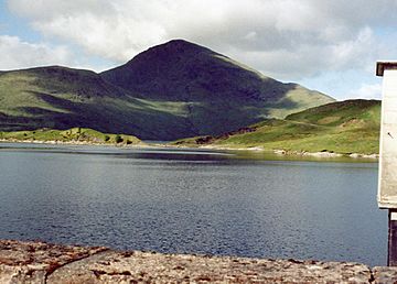
Gairich seen from the Loch Quoich dam.
|
|
| Highest point | |
| Elevation | 919 m (3,015 ft) |
| Prominence | 552 m (1,811 ft) |
| Parent peak | Sgurr na Ciche |
| Listing | Munro, Marilyn |
| Naming | |
| English translation | Roaring |
| Language of name | Gaelic |
| Pronunciation | English approximation: GARR-yish |
| Geography | |
| Location | Lochaber, Highland, Scotland |
| Parent range | Northwest Highlands |
| OS grid | NN025995 |
| Topo map | OS Landranger 33, OS Explorer 414 |
| Climbing | |
| Easiest route | East Ridge from Quoich dam |
Gairich is a cool mountain in Scotland. You can find it on the south side of Loch Quoich. It sits between two valleys, Glen Kingie and Glen Garry. This area is part of Lochaber in the Highland region. Gairich is about 25 kilometres (15 miles) north-northwest of Fort William.
What is Gairich?
Gairich stands 919 metres (3,015 feet) tall. This height means it's just tall enough to be called a Munro. A Munro is a Scottish mountain over 3,000 feet (914.4 metres) high. Even though it's not super tall, Gairich feels wild and far away. It stands out with a prominence of 552 metres. Prominence means how much a mountain rises above its surroundings.
From the Loch Quoich dam, Gairich looks like a pointy cone. Its name comes from the Gaelic word for “roaring” or “Peak of Yelling.” People think this name refers to the loud calls of stags during their mating season.
Exploring Gairich
Gairich has two big bowl-shaped valleys called corries on its sides. One is Coire Liath, on the north side. It's about a kilometre wide and has rocky cliffs. Water from this corrie flows into Loch Quoich.
Years ago, there was a path along Loch Quoich. But in 1957, a hydro-electric scheme raised the loch's water level. This meant the path was covered by water and lost. There's also a small lake called Lochan Doire Meall an Eilein on the mountain's northern slopes.
The eastern side of Gairich has a smaller corrie called Coire Thollaidh. This also drains into the loch. Gairich has three main ridges, which are like long, narrow hills. The northeast and northwest ridges go down to Loch Quoich. If you came by canoe across the loch, you could use these ridges to climb up. The eastern ridge stretches for four kilometres from the top. It ends near the Quoich dam and is a popular way to climb the mountain.
Gairich's Shape
When you see Gairich from the Quoich dam, it looks like a simple cone. But this view can be a bit misleading! The actual top of the mountain is a wide, flat area that goes west for almost two kilometres. It ends at a smaller peak called Gairich Beag, which is 730 metres high.
Gairich is the first mountain in a chain of hills. This chain goes west to another Munro called Sgurr Mòr. It finally ends at Sgurr na Cìche in the very wild area of Knoydart.
The southern side of Gairich drops steeply into a quiet valley called Glen Kingie. This steep slope has a huge, impressive gully. Getting to Gairich from the south can be tricky because the River Kingie can be hard to cross. Sometimes you have to wade through it because there are no bridges. The Kinbreack bothy (a basic shelter) in Glen Kingie is a good spot for climbers exploring this area.
How to Climb Gairich
The most common way to climb Gairich starts at the car park near the Loch Quoich dam.
- First, you walk across the dam wall.
- Then, you follow a path south for about 2.5 kilometres. This path leads you to the lower part of the eastern ridge.
- From there, it's a five-kilometre climb up the ridge to the very top. You'll pass a smaller peak called Bac nam Foid (584 metres) on the way.
- The last part to the summit is a steep climb, with one narrow section that can be a bit tricky.
You can also climb Gairich from the south. This route starts at the end of the road near Loch Arkaig at Strathan. You follow an old path towards Tomdoun in Glen Garry. You'll go as far as the Kinbreack bothy in Glen Kingie. The best place to cross the River Kingie is near the bothy. After crossing, you can climb Gairich from its western side, going over Gairich Beag to reach the summit.
 | Anna J. Cooper |
 | Mary McLeod Bethune |
 | Lillie Mae Bradford |


