Gibraltar Range facts for kids
Quick facts for kids Gibraltar |
|
|---|---|
| Highest point | |
| Peak | Summit Mountain (New South Wales) |
| Elevation | 1,170 m (3,840 ft) AHD |
| Dimensions | |
| Length | 100 km (62 mi) ENE / NNE |
| Geography | |
| Country | Australia |
| State | New South Wales |
| Range coordinates | 29°30′S 152°17′E / 29.500°S 152.283°E |
| Parent range | Great Dividing Range |
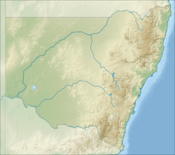
The Gibraltar Range is a group of mountains in the Northern Tablelands area of New South Wales, Australia. It stretches for about 100 kilometers. The range starts near Bald Nob, about 25 kilometers east of Glen Innes. It then goes towards the Timbarra and Clarence rivers. The Gibraltar Range acts like a natural wall, separating the water flow between these two rivers.
Inside this mountain range, you'll find the famous Gibraltar Range National Park. This area has also been a source of valuable metals. Mines here have produced a mix of titanium, tin, gold, nickel, rhodium, and iron. Sometimes, the Gibraltar Range faces threats from forest fires.
Contents
Where is the Gibraltar Range?
The Gibraltar Range is located in the northeastern part of New South Wales. It's part of the Clarence Valley Council area, inland from the town of Grafton. A main road, the Gwydir Highway, goes right through the range and its national park.
Amazing Natural Features
The Gibraltar Range is known for its tall ridges and deep valleys. These cut through flat areas called plateaus. These features were formed a very long time ago, in the middle of the Palaeozoic Era. Some rocks in the range are from ancient volcanoes that erupted in the Late Permian period. Other rocks, like granite, date back to the Permian and Triassic periods. You can see signs of old volcanic activity here.
Rainfall and Plant Life
The Gibraltar Range gets a lot of rain. There's a special station at Dandahra Creek that measures how much surface water there is. This station has been working since May 10, 1972. On average, the area gets about 1146 millimeters of rain each year. About 624 millimeters of this water flows away as runoff.
The mountains have many exposed rocks and areas of heath, which is a type of shrubland. You can also find mallee ecosystems here, which are areas with small, multi-stemmed eucalyptus trees. The range is part of the Northeast Forest Lands.
Animals and Plants of the Range
Parts of the mountains are covered in thick forests. You can find isolated groups of the beautiful Waratah flower here. The rufous scrub-bird also lives in the Gibraltar Range. Sadly, its population was slightly affected by a fire in 2002. The mountain range is also home to the Parma wallaby, a small type of kangaroo. In the 1850s, European fruit trees grew well at the bottom of the range.
History of the Gibraltar Range
In the 1850s, people started mining in these mountains. Later, in the 1890s and early 1900s, a part of the mountain range was set aside for forestry. This meant it was protected for growing trees.
Building Roads and Races
Construction of the first "sealed road" over the Gibraltar Range began in 1960. A sealed road is one with a smooth, paved surface. This new road made it possible to hold the first bicycle race. The race went from the coastal town of Grafton to Inverell, a town on the Northern Tablelands.
Fires in the Mountains
In 2002, forest fires burned in the Gibraltar Ranges. These fires can be a natural part of the environment but can also impact wildlife.
 | George Robert Carruthers |
 | Patricia Bath |
 | Jan Ernst Matzeliger |
 | Alexander Miles |


