Grady County, Georgia facts for kids
Quick facts for kids
Grady County
|
||
|---|---|---|

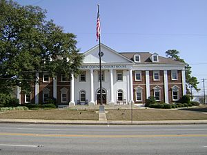
Grady County Courthouse
|
||
|
||

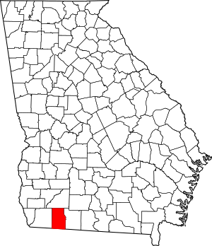
Location within the U.S. state of Georgia
|
||
 Georgia's location within the U.S. |
||
| Country | ||
| State | ||
| Founded | August 17, 1905 | |
| Named for | Henry W. Grady | |
| Seat | Cairo | |
| Largest city | Cairo | |
| Area | ||
| • Total | 460 sq mi (1,200 km2) | |
| • Land | 455 sq mi (1,180 km2) | |
| • Water | 5.7 sq mi (15 km2) 1.2%% | |
| Population
(2020)
|
||
| • Total | 26,236 | |
| • Density | 58/sq mi (22/km2) | |
| Time zone | UTC−5 (Eastern) | |
| • Summer (DST) | UTC−4 (EDT) | |
| Congressional district | 2nd | |
Grady County is a county located in the southern part of the U.S. state of Georgia. It is like a local government area within the state. As of the 2020 census, about 26,236 people lived here. The main town and place where the county government is located is Cairo.
Contents
History of Grady County
Grady County was officially created on August 17, 1905. This happened by a decision from the Georgia General Assembly, which is Georgia's state government. Parts of Decatur and Thomas counties were used to form Grady County.
The county is named after Henry W. Grady. He was a famous newspaper editor for the Atlanta Constitution. He was also known for his great speeches.
Geography and Rivers
According to official records, Grady County covers a total area of 460 square miles. Most of this area, about 455 square miles, is land. The remaining 5.7 square miles, which is about 1.2%, is water.
Most of Grady County, especially around the town of Cairo, is located in the Upper Ochlockonee River area. This river flows through the region. The northwestern part of the county is near the Lower Flint River. The western and southern borders of Grady County are also part of the Lower Ochlockonee River area.
A small part of the county's southeastern side is near the Apalachee Bay-St. Marks area. Grady County also includes a section of the Red Hills Region, which is known for its unique red soil.
Main Roads in Grady County
Neighboring Counties
Grady County shares its borders with several other counties:
- Mitchell County - to the north
- Thomas County - to the east
- Leon County, Florida - to the south
- Gadsden County, Florida - to the southwest
- Decatur County - to the west
Towns and Communities
Grady County has a few main towns and smaller communities.
Cities
Census-Designated Place
- Calvary (This is a special area defined for collecting census data.)
Smaller Communities
- Beachton
- Spence
Population Information
| Historical population | |||
|---|---|---|---|
| Census | Pop. | %± | |
| 1910 | 18,457 | — | |
| 1920 | 20,306 | 10.0% | |
| 1930 | 19,200 | −5.4% | |
| 1940 | 19,654 | 2.4% | |
| 1950 | 18,928 | −3.7% | |
| 1960 | 18,015 | −4.8% | |
| 1970 | 17,826 | −1.0% | |
| 1980 | 19,845 | 11.3% | |
| 1990 | 20,279 | 2.2% | |
| 2000 | 23,659 | 16.7% | |
| 2010 | 25,011 | 5.7% | |
| 2020 | 26,236 | 4.9% | |
| 2023 (est.) | 26,066 | 4.2% | |
| U.S. Decennial Census 1790-1880 1890-1910 1920-1930 1930-1940 1940-1950 1960-1980 1980-2000 2010 |
|||
This table shows the different racial groups living in Grady County as of 2020:
| Race | Num. | Perc. |
|---|---|---|
| White | 14,715 | 56.09% |
| Black or African American | 7,285 | 27.77% |
| Native American | 89 | 0.34% |
| Asian | 110 | 0.42% |
| Pacific Islander | 6 | 0.02% |
| Other/Mixed | 758 | 2.89% |
| Hispanic or Latino | 3,273 | 12.48% |
In 2020, the 2020 United States census counted 26,236 people living in Grady County. There were 9,136 households and 6,320 families in the county at that time.
Education
The public schools in Grady County are managed by Grady County Schools.
See also
 In Spanish: Condado de Grady (Georgia) para niños


