
Grandfather Mountain facts for kids
Quick facts for kids Grandfather Mountain |
|
|---|---|
 |
|
| Highest point | |
| Elevation | 5,946 ft (1,812 m) |
| Prominence | 2,444 ft (745 m) |
| Geography | |
| Location | Avery / Caldwell / Watauga counties, North Carolina, U.S. |
| Parent range | Blue Ridge Mountains |
| Topo map | USGS Grandfather Mountain |
| Climbing | |
| Easiest route | Hike |
Grandfather Mountain is a famous mountain in North Carolina, near Linville, North Carolina. It's not just a mountain; it's also a special place run by a non-profit group and a state park. Standing tall at 5,946 feet (1,812 meters), it's the highest point on the eastern side of the Blue Ridge Mountains. These mountains are a big part of the Appalachian Mountains. The beautiful Blue Ridge Parkway drives right past the mountain's south side. Grandfather Mountain is where Avery, Caldwell, and Watauga counties all meet.
Contents
Discover Grandfather Mountain!
Grandfather Mountain is a truly unique place with a rich history and amazing natural beauty. It offers exciting adventures and a chance to learn about nature.
A Mountain with a Story
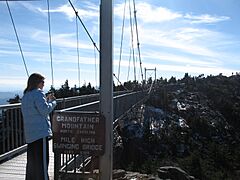
For many years, until 2008, Grandfather Mountain was owned by a private family. They ran it as a nature preserve and a fun place for visitors. The mountain is most famous for its "mile-high swinging bridge." This bridge is the highest in America! It was built in 1952 by a man named Hugh Morton.
The bridge connects two rocky peaks of the mountain. It's called "swinging" because it can sway when strong winds blow. Hugh Morton inherited the mountain from his grandfather. He worked hard to create the attractions that people still enjoy today. Mr. Morton passed away on June 1, 2006. After his death, he gave all his amazing photographs to the University of North Carolina at Chapel Hill. These photos show Grandfather Mountain, its wildlife, and many other parts of life there.
Becoming a State Park
On September 29, 2008, a big announcement was made. North Carolina's Governor, Mike Easley, shared that the state would buy 2,600 acres (10.5 square kilometers) of the mountain. This undeveloped land was purchased from the Morton family for $12 million. This area then became part of the North Carolina State Park system. It was the 34th state park in North Carolina!
The Morton family also created the Grandfather Mountain Stewardship Foundation. This group continues to run the main visitor attraction. They focus on education and protecting nature. Grandfather Mountain State Park officially opened in 2009. The wilder "backcountry" parts of the mountain are now looked after by state park rangers.
The state bought some parts of the mountain directly. For other parts, they made a special agreement. This allowed the Morton family to create a new non-profit group to manage the attraction. This was done because some activities at the attraction didn't fit with state park rules.
On September 18, 2011, the state park celebrated the grand opening of its first office. This office is about 3 miles (4.8 kilometers) from the Profile Trail-head on NC 105.
Caring for the Mountain
The Grandfather Mountain Stewardship Foundation is a special non-profit group. The Morton family started it in 2009. This foundation runs the scenic travel attraction side of Grandfather Mountain.
The Foundation takes care of about 720 acres (291 hectares) of the mountain. This includes the famous Mile High Swinging Bridge, the Nature Museum, and the Animal Habitats. All the money from tickets and souvenirs helps them protect Grandfather Mountain. It also helps them teach visitors about nature and inspire everyone to take care of our Earth.
The Foundation's goal, set in 2014, is to "Inspire conservation of the natural world by helping guests explore, understand and value the wonders of Grandfather Mountain." A team of seven directors manages the Foundation. They hire the leaders and staff who work at the Grandfather Mountain attraction.
What Makes Grandfather Mountain Special?
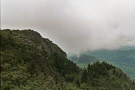
Grandfather Mountain reaches 5,964 feet (1,818 meters) above sea level. Because it's so high, it has 16 different types of natural areas, called ecological communities. The mountain is known for its rough and rugged look. It also has many hidden caves and tall cliffs.
It's been said that Grandfather Mountain has some of the strongest winds ever recorded. Some reports even mentioned speeds over 200 miles per hour (320 km/h)! The mountain has updated its wind measuring tools. These new tools are on the Swinging Bridge. However, the mountain goes even higher, so the very strongest winds might be even higher up.
High Peaks and Rivers
The main ridge of the mountain runs from north to south. It has four important peaks:
- Calloway Peak (5,964 feet)
- Attic Window Peak (5,949 feet)
- MacRae Peak (5,844 feet)
- Linville Peak (5,295 feet)
Even though MacRae Peak isn't the tallest, it's very challenging to reach. This is because of its difficult and exposed paths.
Two rivers start on Grandfather Mountain. The Linville River flows to the east, and the Watauga River flows to the west. Many smaller streams also begin on the mountain's slopes.
Unique Forests and Wildlife
On top of Grandfather Mountain, like many high peaks in North Carolina, there's a special "island" of Southern Appalachian spruce-fir forest. Sadly, many of these trees were damaged in the 20th century by a tiny insect called the balsam wooly adelgid. But some of this unique forest still remains. Many fir trees here are permanently bent by the strong winds that often blow from the west. These mountaintop forests are very important. They provide a valuable home for many different plants and animals that can live in high places.
Exploring the Mountain
There are different ways to experience Grandfather Mountain, whether you want to visit the main attractions or go on a challenging hike.
Visiting the Attraction Side
You can drive up the Grandfather Mountain Entrance Road to reach the attraction side. This area includes the Mile High Swinging Bridge. You'll need to pay an entrance fee at the main gate. Sometimes, parts of the attraction close because of bad weather. This often happens in late fall, winter, and spring.
Hiking and Camping Adventures
Hiking and camping in the "backcountry" part of the mountain, which is now the state park, are free! You just need to get a permit at the trail heads. If you want to enter or leave the park through the main attraction, you still need to pay the entrance fee. In the past, when the whole mountain was private, hikers and campers had to pay fees. State park rangers patrol the trails to make sure everyone follows the rules. Fires are not allowed at many high-up campsites because of strong winds.
The mountain has 11 trails, ranging from easy walks to some of the toughest hikes in the Eastern U.S.
- East Side Trails: You can get to these trails from the Boone Fork parking area on the Blue Ridge Parkway. If the parkway is closed in winter, you can use the Asutsi trail from Highway 221. An easier way to Calloway Peak is the Daniel Boone Scout trail. This trail has two big ladders that help you climb rock faces. The Cragway trail is steeper but offers amazing views.
- West Side Trails: These trails are accessed from NC 105. Look for a wooden sign that says "Profile Parking." The Profile trail climbs for 3.1 miles (5 kilometers). It leads to the Grandfather trail, which is close to Calloway Peak and Attic Window Peak. This trail is named for a rock feature that looks like a human face.
- The Grandfather Trail: This trail is about 2.4 miles (3.9 kilometers) long. It goes along the ridge between Calloway Peak and the Swinging Bridge. It passes Attic Window and MacRae Peaks. This trail is one of the most difficult in the area. It has steep climbs, strong winds, cliffs, and requires using fixed ladders and cables. It takes much longer to hike than a normal trail. In good weather, it's considered advanced. In bad weather, like winter, it's only for very experienced hikers. This is because of ice, snow, low visibility, and freezing winds. In early 2011, the state park closed access to MacRae Peak sometimes for safety.
Fun Things to Do and See
Grandfather Mountain offers many exciting activities and sights for visitors.

The Mile-High Swinging Bridge
This famous bridge is a must-see! It's a thrilling experience to walk across it and enjoy the incredible views. On a clear day, you can see up to 100 miles (160 kilometers) away. You might even spot the skyline of Charlotte!
Scottish Highland Games
Every year, Grandfather Mountain hosts one of North America's biggest Highland games events. People come from all over the world to celebrate Scottish heritage. The games feature traditional Scottish sports and music. Many people wear kilts and other Scottish clothing. It's known as the largest "gathering of clans" in North America.
Amazing Animal Habitats
On the road to the top, you'll find special wildlife exhibits. Grandfather Mountain has six natural habitats for animals. You can see black bears, river otters, cougars, bald eagles, and elk.
One famous resident was Mildred the Bear. She arrived at Grandfather Mountain in 1968 from the Atlanta Zoo. Mildred lived in a special 2-acre (0.8-hectare) habitat built for her in 1973. She passed away in 1993 at 26 years old.

Famous Movie Spot
Did you know Grandfather Mountain was featured in a famous movie? The scene in the 1994 film Forrest Gump where Forrest runs on a winding mountain road was filmed right here!
Mountain Weather
Grandfather Mountain has a humid continental climate. This means it's cooler than most other parts of North Carolina. Winters are cold and snowy, while summers are mild. The mountain gets a lot of rain throughout the year, especially in June and September. The deepest snow usually falls in February.
The earliest snow ever recorded was on September 10, 1964. The latest snow in a season happened on May 27, 1967.
| Climate data for Grandfather Mountain, North Carolina, 1991–2020 normals, extremes 1955–present | |||||||||||||
|---|---|---|---|---|---|---|---|---|---|---|---|---|---|
| Month | Jan | Feb | Mar | Apr | May | Jun | Jul | Aug | Sep | Oct | Nov | Dec | Year |
| Record high °F (°C) | 63 (17) |
67 (19) |
76 (24) |
80 (27) |
78 (26) |
83 (28) |
85 (29) |
83 (28) |
80 (27) |
79 (26) |
69 (21) |
63 (17) |
85 (29) |
| Mean daily maximum °F (°C) | 37.3 (2.9) |
39.8 (4.3) |
45.6 (7.6) |
55.3 (12.9) |
62.2 (16.8) |
68.5 (20.3) |
71.9 (22.2) |
70.5 (21.4) |
65.5 (18.6) |
56.9 (13.8) |
48.1 (8.9) |
41.7 (5.4) |
55.3 (12.9) |
| Daily mean °F (°C) | 29.1 (−1.6) |
31.3 (−0.4) |
37.5 (3.1) |
46.6 (8.1) |
54.5 (12.5) |
61.4 (16.3) |
64.8 (18.2) |
63.6 (17.6) |
58.5 (14.7) |
49.2 (9.6) |
40.0 (4.4) |
33.7 (0.9) |
47.5 (8.6) |
| Mean daily minimum °F (°C) | 21.0 (−6.1) |
22.8 (−5.1) |
29.4 (−1.4) |
37.8 (3.2) |
46.8 (8.2) |
54.2 (12.3) |
57.6 (14.2) |
56.7 (13.7) |
51.5 (10.8) |
41.5 (5.3) |
31.9 (−0.1) |
25.7 (−3.5) |
39.7 (4.3) |
| Record low °F (°C) | −32 (−36) |
−19 (−28) |
−9 (−23) |
5 (−15) |
17 (−8) |
31 (−1) |
41 (5) |
36 (2) |
24 (−4) |
12 (−11) |
−8 (−22) |
−21 (−29) |
−32 (−36) |
| Average precipitation inches (mm) | 5.01 (127) |
3.93 (100) |
5.38 (137) |
5.90 (150) |
6.05 (154) |
6.36 (162) |
6.21 (158) |
5.76 (146) |
6.45 (164) |
4.98 (126) |
4.19 (106) |
4.53 (115) |
64.75 (1,645) |
| Average snowfall inches (cm) | 13.7 (35) |
13.0 (33) |
7.9 (20) |
6.0 (15) |
0.5 (1.3) |
0.0 (0.0) |
0.0 (0.0) |
0.0 (0.0) |
0.0 (0.0) |
0.4 (1.0) |
2.4 (6.1) |
9.6 (24) |
53.5 (135.4) |
| Source: NOAA (snow/snow days 1981–2010) | |||||||||||||
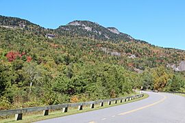
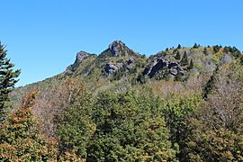
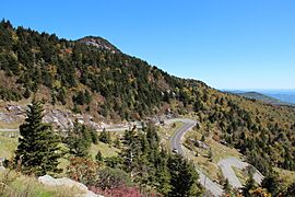
Photo Gallery
-
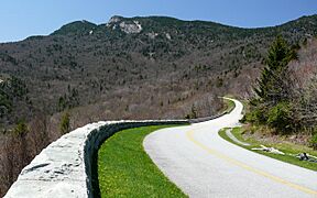
The Blue Ridge Parkway.
-
Mile-High Swinging Bridge.
-
View of Linville Peak from Top Shop upper parking lot.
-
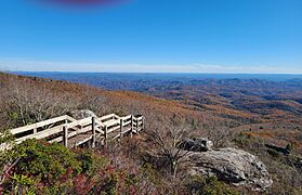
Rough Ridge Lookout at Grandfather Mountain.
-
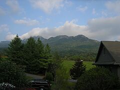
View from Grandfather Golf & Country Club entrance.
-
View from Beacon Heights.
-
View from Half Moon Overlook.
-
Hairpin turns on the mountain.
-
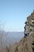
One of several "Grandfather" profiles on the mountain.
-
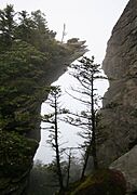
View from near MacRae Peak summit.


.jpg)
Nearby Parks and Forests
If you love nature, there are other great state parks and forests close to Grandfather Mountain State Park. Here are some within 30 miles (48 kilometers):
- Elk Knob State Park
- Lake James State Park
- Mount Jefferson State Natural Area
- Mount Mitchell State Park
- New River State Park
- Rendezvous Mountain State Park
- Roan Mountain State Park, Tennessee
- Tuttle Educational State Forest
A bit further away, about 110 miles (177 kilometers) from Grandfather Mountain State Park, you can find:
- DuPont State Forest
- The city of Brevard, which is near many trails in Pisgah National Forest.
See Also
