
Great Basin water resource region facts for kids
The Great Basin water resource region is a very large area in the western United States. It's one of 21 main geographic areas that scientists use to organize how water flows across the country. The United States Geological Survey (USGS) created this system to help understand and manage water.
These regions are like big natural bowls that collect water. They include the areas where a major river flows, or where several rivers combine their waters.
The Great Basin region has a special code, 16, in this system. It covers about 141,717 square miles (367,000 km²). This huge area is divided into 6 smaller parts, called subregions, each with its own code from 1601 to 1606.
This region includes the natural drainage area of the Great Basin. Water in this region flows into states like Utah and Nevada. It also touches parts of California, Idaho, Oregon, and Wyoming.

Contents
Understanding the Great Basin's Water Subregions
The Great Basin water resource region is divided into six smaller areas. Each of these subregions has its own unique features and ways that water flows within it. Let's explore them!
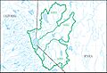
Bear Subregion (1601)
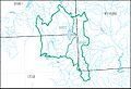
The Bear subregion is mainly the area where the Bear River flows. This river is the largest tributary to the Great Salt Lake.
- Location: You can find this subregion in parts of Idaho, Utah, and Wyoming.
- Size: It covers about 7,310 square miles (18,930 km²).
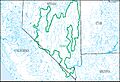
Great Salt Lake Subregion (1602)
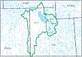
This subregion includes the large area that drains into the Great Salt Lake, but it doesn't include the Bear River's basin.
- Location: It stretches across parts of Idaho, Nevada, Utah, and Wyoming.
- Size: This is a big one, covering around 28,700 square miles (74,330 km²).
Escalante Desert–Sevier Lake Subregion (1603)
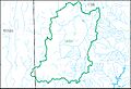
This subregion includes two closed basins: the Escalante Desert and the Sevier Lake area. A "closed basin" means water flows into it but doesn't flow out to the ocean.
Black Rock Desert–Humboldt Subregion (1604)
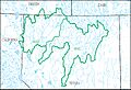
This subregion includes the Humboldt River basin and the Black Rock Desert. It also has other closed basins that collect water in northwestern Nevada.
- Location: You'll find this subregion in parts of California, Nevada, and Oregon.
- Size: It covers approximately 28,300 square miles (73,290 km²).
Central Lahontan Subregion (1605)
The Central Lahontan subregion is made up of the basins for the Carson River, Truckee River, and Walker River. These rivers are important for water supply in the area.
- Location: This subregion is located in California and Nevada.
- Size: It's about 12,500 square miles (32,370 km²).
Central Nevada Desert Basins Subregion (1606)
This subregion includes several closed desert basins that collect water in south-central Nevada.
- Location: You'll find this area in California and Nevada.
- Size: This is the largest subregion, covering about 47,100 square miles (121,990 km²).
Images for kids
-
Map of the Bear subregion (1601)
-
Map of the Great Salt Lake subregion (1602)
-
Map of the Escalante Desert–Sevier Lake subregion (1603)
-
Map of the Black Rock Desert–Humboldt subregion (1604)
-
Map of the Central Lahontan subregion (1605)
-
Map of the Central Nevada Desert Basins subregion (1606)


