
Greymouth facts for kids
Quick facts for kids
Greymouth
Māwhera (Māori)
|
|
|---|---|

Greymouth, 2020
|
|
| Country | New Zealand |
| Region | West Coast |
| District | Grey District |
| Ward | Central |
| Named for | Sir George Grey, governor of New Zealand |
| Area | |
| • Total | 27.70 km2 (10.70 sq mi) |
| Population
(June 2023)
|
|
| • Total | 8,340 |
| • Density | 301.08/km2 (779.8/sq mi) |
| Time zone | UTC+12 (NZST) |
| • Summer (DST) | UTC+13 (NZDT) |
| Postcode(s) |
7805
|
| Local iwi | Ngāi Tahu |
Greymouth (pronounced "gray-mouth") is the biggest town in the West Coast area of New Zealand's South Island. It's also the main town for the Grey District Council. Its Māori name is Māwhera, which means 'wide spread river mouth'.
Greymouth is home to about 7,962 people. A big part of the Grey District, about 65%, is protected land managed by the Department of Conservation. This makes Greymouth a great spot for people who love walking and hiking.
Contents
Location of Greymouth

Greymouth is located where the Grey River meets the sea. It sits on a flat coastal area near the Southern Alps mountains. On clear days, you can even see Aoraki / Mount Cook, New Zealand's tallest mountain, from the town.
The river mouth divides Greymouth into three main parts:
- Blaketown is on the south side, close to the river's mouth.
- Karoro is to the southeast, separated from Blaketown by small lagoons.
- Cobden is on the river's north side and used to be a separate town.
Greymouth is connected by major roads. State Highway 6 links it to Hokitika in the south and Westport in the north. State Highway 7 runs through towns like Dobson and Reefton, eventually reaching Canterbury. The town is also the end point for the Midland train line from Christchurch. Large coal trains use this line, and the famous TranzAlpine tourist train also stops here. Greymouth also has its own airport, just a short distance south of the town centre.
Greymouth's Climate
Greymouth has an oceanic climate, which means it has mild temperatures and a lot of rain. The town gets a lot of rain all year round because of its location. Winds from the west bring moisture from the ocean, which often hits the Southern Alps. This creates a "rain shadow" effect, making the east coast of New Zealand much sunnier and warmer.
Because of the strong ocean influence, Greymouth doesn't get very hot summers or very cold winters. Snow is quite rare here.
| Climate data for Greymouth (1991–2020 normals, extremes 1947–present) | |||||||||||||
|---|---|---|---|---|---|---|---|---|---|---|---|---|---|
| Month | Jan | Feb | Mar | Apr | May | Jun | Jul | Aug | Sep | Oct | Nov | Dec | Year |
| Record high °C (°F) | 30.9 (87.6) |
29.8 (85.6) |
27.7 (81.9) |
25.0 (77.0) |
23.8 (74.8) |
18.8 (65.8) |
18.4 (65.1) |
19.3 (66.7) |
22.3 (72.1) |
23.2 (73.8) |
26.5 (79.7) |
28.8 (83.8) |
30.9 (87.6) |
| Mean daily maximum °C (°F) | 19.1 (66.4) |
19.8 (67.6) |
18.7 (65.7) |
16.5 (61.7) |
14.5 (58.1) |
12.3 (54.1) |
11.8 (53.2) |
12.6 (54.7) |
13.7 (56.7) |
14.6 (58.3) |
15.9 (60.6) |
17.9 (64.2) |
15.6 (60.1) |
| Daily mean °C (°F) | 15.8 (60.4) |
16.3 (61.3) |
15.0 (59.0) |
12.9 (55.2) |
11.0 (51.8) |
8.9 (48.0) |
8.0 (46.4) |
9.0 (48.2) |
10.2 (50.4) |
11.3 (52.3) |
12.6 (54.7) |
14.6 (58.3) |
12.1 (53.8) |
| Mean daily minimum °C (°F) | 12.5 (54.5) |
12.7 (54.9) |
11.4 (52.5) |
9.4 (48.9) |
7.5 (45.5) |
5.5 (41.9) |
4.3 (39.7) |
5.4 (41.7) |
6.7 (44.1) |
7.9 (46.2) |
9.3 (48.7) |
11.4 (52.5) |
8.7 (47.6) |
| Record low °C (°F) | 3.8 (38.8) |
1.5 (34.7) |
0.1 (32.2) |
−0.1 (31.8) |
−2.2 (28.0) |
−2.5 (27.5) |
−2.6 (27.3) |
−2.4 (27.7) |
−2.4 (27.7) |
−1.8 (28.8) |
1.0 (33.8) |
2.9 (37.2) |
−2.6 (27.3) |
| Average rainfall mm (inches) | 213.4 (8.40) |
158.8 (6.25) |
175.1 (6.89) |
201.3 (7.93) |
209.7 (8.26) |
232.9 (9.17) |
196.7 (7.74) |
204.4 (8.05) |
201.5 (7.93) |
226.6 (8.92) |
190.0 (7.48) |
232.6 (9.16) |
2,443 (96.18) |
| Mean monthly sunshine hours | 207.6 | 195.1 | 178.3 | 140.9 | 109.2 | 92.5 | 113.7 | 136.8 | 142.5 | 161.1 | 181.8 | 186.0 | 1,845.5 |
| Source: NIWA | |||||||||||||
In 2005, a large tornado hit the Blaketown area of Greymouth. It caused a lot of damage and injured several people. Smaller tornadoes had also hit the town in 2001 and 2003.
The Barber Wind

A special wind blows down the Grey Valley, and locals call it the "Barber." It's a cold wind that often brings mist with it. In the past, people even advertised special clothing to help keep warm against the Barber's chill.
Flooding in Greymouth

The West Coast gets a lot of rain, and its rivers are short and steep. This often leads to quick floods in low-lying areas. Greymouth has experienced many floods from the Grey River over the years. Some of the biggest floods even got special names, like the Great Flood of 1872 or the Big One in 1988.
After two major floods in 1988, the mayor of Greymouth, Barry Dallas, decided to build a large flood protection wall. This wall was finished in 1990 and cost a lot of money. Since the wall was built, Greymouth has not had any major floods, even when the river has risen very high.
Local Walks and Trails
Since a large part of the Grey District is protected land, there are many great walking trails to explore.
Coal Creek Track

This easy walk goes down to the Coal Creek valley through a forest with different types of trees. It's about 3.6 kilometers long (return trip) and you can find it about 8 kilometers northeast of Greymouth, near Runanga.
King Domain Walk
This walk is a zigzag path that goes uphill. It has four lookout points where you can see amazing views of Greymouth and the Grey Valley. You'll see the town centre, the Grey River, and even the area of Cobden.
Kōwhai Bush Walk
This short loop walk is located near Anzac Park. It takes you through a Kōwhai forest, with half of the path next to the Blaketown Lagoon. There are boardwalks that go through the plants that grow near the water.
Omotomotu Bush Walk
This walk is in the biggest forest area close to Greymouth. It's a 25-minute loop track located on Marsden Road. Halfway through, there's a path to a lookout point with views of the growing forest.
Point Elizabeth Walkway

This walk is 5.5 kilometers long (one way) and offers stunning views from the cliff tops. It's a well-made path that goes through coastal bush. You can start this walk from North Beach Road in Cobden or Seven Mile Road in Rapahoe.
Woods Creek Walk
This forest track takes you past old water channels, dams, and tunnels that gold miners built in the 1800s. It's a 1.1-kilometer loop track located about 30 kilometers southeast of Greymouth.
History of Greymouth

Early Māori Settlement
Evidence shows that Māori people lived on the West Coast of New Zealand's South Island as far back as 1300–1400 AD. Places like Karamea and Jackson Bay had early settlements. People cooked in earth ovens (hāngī) and left behind rubbish piles (middens). These show that early Māori ate moa (a large, now extinct bird) and seals, along with fish. These first people were from East Polynesia. Over time, other Māori tribes (iwi) moved to the West Coast as the population grew.
Ngāi Tahu and Greenstone
The Ngāi Tahu tribe arrived on the West Coast, known as Te Tai Poutini, around the early 1800s. Led by the warrior Tūhuru Kōkare, they fought battles to control the greenstone (pounamu) coast. The West Coast was a very important source of this valuable greenstone, which is almost as hard as steel. The Poutini Ngāi Tahu built strong villages (pā) at Māwhera (Greymouth), Ōkārito, and Mahitahi. The name Māwhera, meaning 'wide spread river mouth', is still used for the Grey River today.
European Arrival
The first Europeans to visit the area where Greymouth now stands were Thomas Brunner and Charles Heaphy in 1846. They were exploring the land south of the Buller River. Brunner found coal in the Grey Valley, and places like the town of Brunner and Lake Brunner are named after him. Brunner himself named the Grey River after Sir George Grey, who was the Governor of New Zealand at the time.
As more European settlers arrived in Nelson and Canterbury, they became interested in the West Coast. However, the land still belonged to the Māori, specifically the Poutini Ngāi Tahu. In 1857, the Māori chiefs offered to sell the land for £2500, but they wanted to keep some land for themselves and their rights to the pounamu (greenstone) from the Arahura River.
In 1859, James Mackay was sent to arrange the purchase. This agreement, called the Arahura Deed, was signed in Māwhera by the chiefs on May 21, 1860. The entire West Coast was sold to the Crown for only £300, except for some reserved areas, including Māwhera, which is now the centre of Greymouth.
On July 22, 1864, the ship Nelson was the first steamer to cross the Grey River bar and sail up the river. On board were Matthew Batty and Reuben Waite, along with about 70 gold prospectors. Reuben Waite opened the first store in Greymouth. Matthew Batty became the first European coal miner on the Grey River.
John Rochfort surveyed the town site in 1865. Greymouth officially became a borough on July 16, 1868. On September 16, 1868, the new town council held its first meeting and chose Edward Masters as the first mayor of Greymouth.

From 1853 to 1876, Greymouth was part of the Canterbury Province. However, Cobden, on the north side of the Grey River, was part of the Nelson Province. This was confusing because the West Coast gold rush brought many people to both sides of the border. Eventually, the area became its own province called Westland Province in 1873.
Shipwrecks at the Greymouth Bar

The Greymouth Bar is a sandbar at the mouth of the Grey River. It is known for being very dangerous, and more than 44 ships have been wrecked there. The first shipwreck happened on September 13, 1863. Since 1865, 16 lives have been lost.
The year 1866 was the most dangerous for ships in Greymouth, with five ships being wrecked for various reasons, including getting stuck on the sand or having engine problems.
On June 23, 1910, the ship Lauderdale was heading to Greymouth and ended up stranded on Blaketown beach. The Lauderdale is one of three shipwrecks that can still be seen on the Greymouth coastline today, depending on the tides. The other two are the Abel Tasman and the Hawea.
Greymouth's Economy
Greymouth was founded during the West Coast gold rush in the 1860s. For 150 years after that, its main industries were coal mining and cutting down native timber. These industries made the town very successful. At one point, Greymouth had 47 hotels! Today, most of the coal mines have closed. In the past, there were ten coal mines in the Brunner area alone, producing over 8 million tonnes of coal. Fishing has also always been important to the town, even though the entrance to the Grey River is known for its dangerous sandbars.
Starting in the 1960s, both forestry and coal mining began to slow down on the West Coast. The opening of the Pike River Mine in 2008 brought new hope and investment, but sadly, on November 19, 2010, there was an explosion at the Pike River Mine, trapping 29 miners. A second explosion on November 24 meant there was no hope for their survival. After this tragedy, the company went out of business, and another mine, Spring Creek Mine, also closed, leading to many job losses.
After the decline of mining and forestry, the West Coast economy has started to rely more on ecotourism. Thousands of mining jobs have been replaced by hundreds of tourism jobs.
During Greymouth's busy years, many buildings in the town centre were built on land leased from the Māori. This land is now managed by the Ngāi Tahu tribe's company, Mawhera Inc. Mawhera Inc is now the town's biggest landlord. After new building safety rules were put in place, many of Greymouth's old buildings were found to be unsafe. It's often too expensive to fix them up, especially because they are on leased land.
Greymouth is also famous for its pounamu (greenstone) carving industry, which has a long history with the Māori people. The town's local brewery, Monteith's, has been making beer since 1868, and it's now sold all over New Zealand.
Education in Greymouth
Greymouth has several primary schools for younger students (up to Year 8). For secondary education, there's Greymouth High School and John Paul II High School. There are also Catholic primary and secondary schools.
Tai Poutini Polytechnic has its main office in Greymouth. This polytechnic offers different courses and has campuses in other towns across New Zealand.
Arts and Culture
Left Bank Art Gallery

The Left Bank Art Gallery in Greymouth opened in 1992. It's located in an old bank building on the left side of the Grey River. The gallery shows art from artists all over the West Coast and has a special collection of Pounamu (greenstone) art.
Art in the Park
The "Art in the Park" event started in Greymouth in 2007. It's a chance for artists to show their work outdoors. Over the years, it has moved to different locations, including Shantytown and the Greymouth High School gymnasium.
Greymouth Operatic Society
The Greymouth Operatic Society was officially formed in 1944. This group puts on musical shows and concerts. Today, it's a busy group that helps local performers, musicians, and stage crews learn about theatre. Their goal is to support and teach local talent.
Greymouth Suburbs
- Inner suburbs:
- Cobden – This area's name and many street names come from English politicians and reformers.
- Greymouth Central – The Māori name is Māwhera. Many early street names honor pioneers, explorers, and important local Māori figures.
- Blaketown – Named after its founder, Isaac Blake, who was a gold prospector who became a successful trader. In its early days, Blaketown was actually bigger than Greymouth.
- Wharemoa
- Karoro – In Māori, this means 'black-backed gull' or 'seagull'. The street names here often come from developers or landowners.
- Outer suburbs:
- South Beach
- Paroa – In Māori, this means 'long fortified village'. The streets here are mostly named after important local people and landowners.
- Rutherglen
- Gladstone
- Camerons

Notable People from Greymouth
- Mary Anderson (1887–1966), a politician and one of the first members of the Greymouth Labour Party.
- Julie Christie (born 1962), a TV producer who grew up in Greymouth.
- Paul Coll (born 1992), a squash player born in Greymouth.
- Kevin Hague (born 1960), a politician who lives in Greymouth.
- Tony Kokshoorn (born 1955), a politician and activist born and living in Greymouth.
- Bill Pearson (1922–2002), a writer born in Greymouth.
- Gaylene Preston (born 1947), a filmmaker born in Greymouth.
- Jackie Thomas (born 1990), a singer born in Greymouth.
Notable Buildings in Greymouth
- Bank of New Zealand (1 Tainui Street), which is now home to the Left Bank Art Gallery.
- The Regent Theatre (built in 1937).
- The Greymouth Railway Station, which is part of a historic area that includes the signal box and old government buildings.
Images for kids
-
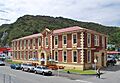
The former Greymouth Government buildings
-
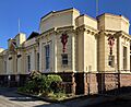
Greymouth Courthouse building
-
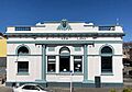
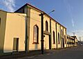
Left Bank Art Gallery, in the old Bank of New Zealand building
-
History House museum, the former Grey County Chambers
-
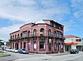
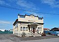
Greymouth Royal Hotel
-
Dispatch & Garlick Foundry
-
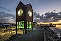
Town clock


See also
 In Spanish: Greymouth para niños
