Grundy County, Iowa facts for kids
Quick facts for kids
Grundy County
|
|
|---|---|

|
|

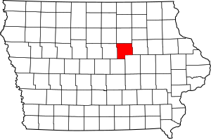
Location within the U.S. state of Iowa
|
|
 Iowa's location within the U.S. |
|
| Country | |
| State | |
| Founded | 1851 |
| Named for | Felix Grundy |
| Seat | Grundy Center |
| Largest city | Grundy Center |
| Area | |
| • Total | 502 sq mi (1,300 km2) |
| • Land | 502 sq mi (1,300 km2) |
| • Water | 0.04 sq mi (0.1 km2) 0.01% |
| Population
(2020)
|
|
| • Total | 12,329 |
| • Density | 24.560/sq mi (9.483/km2) |
| Time zone | UTC−6 (Central) |
| • Summer (DST) | UTC−5 (CDT) |
| Congressional district | 4th |
Grundy County is a county located in the state of Iowa in the United States. A county is like a smaller region within a state, often with its own local government. In 2020, about 12,329 people lived here. The main town, or county seat, where the county government is located, is Grundy Center. The county is named after Felix Grundy, who was an important government official in the U.S. a long time ago.
Grundy County is part of the larger Waterloo-Cedar Falls area, which is a big group of cities and towns that are connected.
Contents
History of Grundy County
Grundy County was officially created on January 15, 1851. It started to govern itself, meaning it set up its own local government, in 1856. The county got its name from Felix Grundy of Tennessee. He was a very important person in American politics, serving as a Senator, a member of the House of Representatives, and even the Attorney General (the country's chief lawyer) under President James K. Polk.
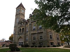
The first building used for the county government, called a courthouse, was built in 1861. It was a two-story wooden building. Inside, there was a courtroom where legal cases were heard. It also had offices for important county officials like the sheriff and the treasurer, and a room for the jury (the group of citizens who help decide court cases). A second, newer courthouse was started on November 11, 1891.
Geography of Grundy County
Grundy County covers a total area of about 502 square miles (about 1,300 square kilometers). Almost all of this area is land, with only a tiny bit being water.
Main Roads
These are the most important highways that run through Grundy County:
Neighboring Counties
Grundy County shares its borders with these other counties:
- Butler County (to the north)
- Black Hawk County (to the east)
- Tama County (to the southeast)
- Marshall County (to the southwest)
- Hardin County (to the west)
- Franklin County (to the northwest)
People of Grundy County (Demographics)
A census is like a big count of all the people living in an area. The U.S. government does a census every ten years to learn about the population.
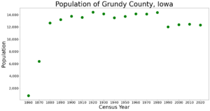
| Historical population | |||
|---|---|---|---|
| Census | Pop. | %± | |
| 1860 | 793 | — | |
| 1870 | 6,399 | 706.9% | |
| 1880 | 12,639 | 97.5% | |
| 1890 | 13,215 | 4.6% | |
| 1900 | 13,757 | 4.1% | |
| 1910 | 13,574 | −1.3% | |
| 1920 | 14,420 | 6.2% | |
| 1930 | 14,133 | −2.0% | |
| 1940 | 13,518 | −4.4% | |
| 1950 | 13,722 | 1.5% | |
| 1960 | 14,132 | 3.0% | |
| 1970 | 14,119 | −0.1% | |
| 1980 | 14,366 | 1.7% | |
| 1990 | 12,029 | −16.3% | |
| 2000 | 12,369 | 2.8% | |
| 2010 | 12,453 | 0.7% | |
| 2020 | 12,329 | −1.0% | |
| 2023 (est.) | 12,384 | −0.6% | |
| U.S. Decennial Census 1790-1960 1900-1990 1990-2000 2010-2018 |
|||
What the 2020 Census Showed
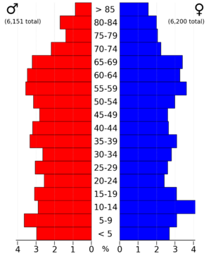
The 2020 census counted 12,329 people living in Grundy County. This means there were about 25 people living in each square mile (this is called population density). Most people (about 97%) said they belonged to one race. About 95% of the people were non-Hispanic White. Other groups included Black, Hispanic, Native American, and Asian people. Some people also identified as more than one race.
There were 5,465 places where people could live (called housing units), and most of them (5,069) were being lived in.

What the 2010 Census Showed
In 2010, the census counted 12,453 people in the county. The population density was similar to 2020. There were 5,530 housing units, and 5,131 of them were occupied.
Towns and Communities
Grundy County has several towns and smaller communities.
Cities
Townships
A township is a smaller area within a county, often used for local administration.
- Beaver Township
- Black Hawk Township
- Clay Township
- Colfax Township
- Fairfield Township
- Felix Township
- German Township
- Grant Township
- Lincoln Township
- Melrose Township
- Palermo Township
- Pleasant Valley Township
- Shiloh Township
- Washington Township
How Big Are the Cities?
This table shows the population of the cities in Grundy County, based on the 2020 census. The city marked with a dagger (†) is the county seat.
| Rank | City/Town/etc. | Type | Population (2020 Census) |
|---|---|---|---|
| 1 | † Grundy Center | City | 2,796 |
| 2 | Reinbeck | City | 1,662 |
| 3 | Dike | City | 1,304 |
| 4 | Conrad | City | 1,093 |
| 5 | Wellsburg | City | 720 |
| 6 | Holland | City | 269 |
| 7 | Stout | City | 191 |
| 8 | Beaman | City | 161 |
| 9 | Morrison | City | 98 |
See also
 In Spanish: Condado de Grundy (Iowa) para niños


