Guayas River facts for kids
Quick facts for kids Guayas River |
|
|---|---|

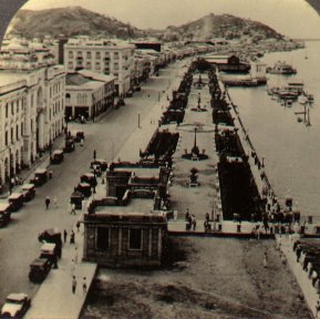
The Guayas River in Guayaquil, 1920
|
|
|
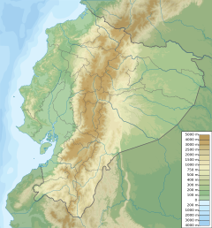
Location of mouth
|
|
| Other name(s) | Rio Guayas |
| Country | Ecuador |
| Province | Guayas Province |
| Physical characteristics | |
| River mouth | Gulf of Guayaquil, Pacific Ocean 0 m (0 ft) 2°39′05″S 79°54′33″W / 2.651358°S 79.909052°W |
The Guayas River, also known as Rio Guayas, is a very important river in western Ecuador. It gives its name to the Guayas Province. This river is special because it is the most important river in South America that flows into the Pacific Ocean, not the Atlantic Ocean or its nearby seas.
The Guayas River, including the Daule River, is about 389 kilometers (241 miles) long. Its drainage basin, which is the area of land where all the water flows into the river, covers 34,500 square kilometers (13,320 sq mi). On average, it carries about 1,982 cubic meters (70,000 cubic feet) of water every second. The Guayas River is considered a national symbol of Ecuador and is even shown on the country's Coat of Arms.
Contents
River Journey: Where the Guayas Flows
River's Beginning and Path
The Guayas River starts high up in the Andes mountains. One of its sources is near Chimborazo (volcano), which is Ecuador's highest volcano. The Coat of Arms of Ecuador actually shows a picture of the river flowing down from this mountain.
The name Guayas refers to the lower part of the river. This part begins where two other rivers meet: the Daule River from the west and the Babahoyo River from the east. This meeting point is between the cities of Guayaquil and Durán, in Guayas province.
After these two rivers join, the Guayas River flows around Santay Island. Then, it becomes one large river again. From where it forms to its delta, about 60 kilometers (37 miles) away, it flows past areas like Guayaquil (canton) and Durán cantons, and then Guayaquil and Naranjal cantons, just before reaching the delta.
The River's Delta and Mouth
The Guayas River forms a very complex delta, which is a landform created when a river deposits sediment as it enters a larger body of water. A key part of this delta is a narrow waterway called Estero Salado. This area is surrounded by swamps and is affected by the ocean's tides.
The land between the Guayas River and the Estero Salado is like a maze of islands. Some of these islands have become homes for many people. The Cobina Slough is another waterway that connects the Estero Salado with the main Guayas River.
The main part of the Guayas River is also affected by the tides. It forms a small group of islands, with Mondragón being the most important. Finally, the river flows into the Gulf of Guayaquil, which is a large inlet of the Pacific Ocean. The river's influence can be seen as far as Puná Island and the Jambelí Strait in the El Oro province.
Guayas River Watershed
The Guayas River has the largest watershed on the western side of the Andes mountains in South America that flows into the Pacific Ocean. This huge area covers 34,500 square kilometers (13,320 sq mi).
The watershed includes parts of nine different provinces in Ecuador: Los Ríos, Guayas, Bolívar, Manabí, Cañar, Pichincha, Azuay, Chimborazo, and Cotopaxi. Every year, the Guayas River, along with the Estero Salado, empties about 36 billion cubic meters of water into the Gulf of Guayaquil.
Major Cities Along the Guayas River System
Many cities and towns are located along the Guayas River and its main branches.
Cities Along the Daule River
Cities Along the Babahoyo River
Cities Along the Guayas River Itself
See also
 In Spanish: Río Guayas para niños
- National symbols of Ecuador
 | Shirley Ann Jackson |
 | Garett Morgan |
 | J. Ernest Wilkins Jr. |
 | Elijah McCoy |


