Gulf Shores, Alabama facts for kids
Quick facts for kids
Gulf Shores, Alabama
|
|||
|---|---|---|---|

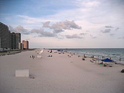
Condominiums and hotels on the beach
|
|||
|
|||
| Motto(s):
Small Town, Big Beach
|
|||

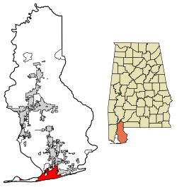
Location of Gulf Shores in Baldwin County, Alabama.
|
|||
| Country | United States | ||
| State | Alabama | ||
| County | Baldwin | ||
| Area | |||
| • Total | 33.21 sq mi (86.01 km2) | ||
| • Land | 28.36 sq mi (73.46 km2) | ||
| • Water | 4.84 sq mi (12.55 km2) | ||
| Elevation | 7 ft (2 m) | ||
| Population
(2020)
|
|||
| • Total | 15,014 | ||
| • Density | 529.35/sq mi (204.38/km2) | ||
| Time zone | UTC−6 (Central (CST)) | ||
| • Summer (DST) | UTC−5 (CDT) | ||
| ZIP Codes |
36542, 36547
|
||
| Area code(s) | 251 | ||
| FIPS code | 01-32272 | ||
| GNIS feature ID | 0119462 | ||
Gulf Shores is a fun resort city located in Baldwin County, Alabama, United States. It's a popular spot for vacations and beach trips! In 2020, about 15,014 people lived there, making it a growing community.
Contents
Exploring Gulf Shores' Location
Gulf Shores is right on the Gulf of Mexico. It is the southernmost city in Alabama. This means it has amazing beaches and warm ocean water.
You can get to Gulf Shores using Alabama State Route 59, which goes north to Foley. Alabama State Route 182 (Beach Boulevard) runs along the coast. Another road, Alabama State Route 180 (Fort Morgan Road), runs next to it, north of Little Lagoon. A big part of the city to the east is taken up by Gulf State Park.
The city covers about 86 square kilometers (33.2 square miles). Most of this is land, but about 12.5 square kilometers (4.8 square miles) is water, like parts of the Gulf and lagoons.
Weather in Gulf Shores
Gulf Shores has a humid subtropical climate. This means it has long, hot summers and mild, sunny winters.
- In winter, daily high temperatures are usually around 16°C (60°F). Nighttime lows are near 4°C (40°F).
- In summer, daytime highs are around 32°C (90°F). Evening lows are near 26°C (78°F).
- The ocean water is very warm from May through November, often reaching over 26°C (80°F).
Because it's on the Gulf of Mexico, Gulf Shores can be affected by tropical cyclones, also known as hurricanes. These strong storms can bring a lot of wind and rain.
- In 1979, Hurricane Frederic caused a lot of damage.
- In 2004, Hurricane Ivan hit, causing widespread damage.
- In 2005, Hurricane Katrina also caused damage and flooding.
- Most recently, in 2020, Hurricane Sally made landfall, bringing more damage and flooding.
| Climate data for Gulf Shores, Alabama | |||||||||||||
|---|---|---|---|---|---|---|---|---|---|---|---|---|---|
| Month | Jan | Feb | Mar | Apr | May | Jun | Jul | Aug | Sep | Oct | Nov | Dec | Year |
| Record high °F (°C) | 81 (27) |
77 (25) |
81 (27) |
88 (31) |
95 (35) |
96 (36) |
101 (38) |
98 (37) |
97 (36) |
93 (34) |
84 (29) |
84 (29) |
101 (38) |
| Mean daily maximum °F (°C) | 59 (15) |
62 (17) |
67 (19) |
74 (23) |
82 (28) |
87 (31) |
89 (32) |
89 (32) |
86 (30) |
78 (26) |
69 (21) |
62 (17) |
75 (24) |
| Mean daily minimum °F (°C) | 45 (7) |
49 (9) |
55 (13) |
63 (17) |
71 (22) |
76 (24) |
78 (26) |
78 (26) |
75 (24) |
66 (19) |
56 (13) |
48 (9) |
63 (17) |
| Record low °F (°C) | 9 (−13) |
20 (−7) |
23 (−5) |
30 (−1) |
50 (10) |
55 (13) |
65 (18) |
64 (18) |
52 (11) |
37 (3) |
24 (−4) |
11 (−12) |
9 (−13) |
| Average precipitation inches (mm) | 5.29 (134) |
5.49 (139) |
5.31 (135) |
4.27 (108) |
4.41 (112) |
5.14 (131) |
6.23 (158) |
7.19 (183) |
5.38 (137) |
3.85 (98) |
4.14 (105) |
4.87 (124) |
61.57 (1,564) |
| Source: The Weather Channel | |||||||||||||
People Living in Gulf Shores
| Historical population | |||
|---|---|---|---|
| Census | Pop. | %± | |
| 1960 | 356 | — | |
| 1970 | 909 | 155.3% | |
| 1980 | 1,349 | 48.4% | |
| 1990 | 3,261 | 141.7% | |
| 2000 | 5,044 | 54.7% | |
| 2010 | 9,741 | 93.1% | |
| 2020 | 15,014 | 54.1% | |
| U.S. Decennial Census | |||
Gulf Shores has grown a lot over the years. In 1960, only 356 people lived there. By 2020, the population had grown to over 15,000!
Population in 2020
In 2020, there were 15,014 people living in Gulf Shores. There were 5,810 households, which are groups of people living in the same home. About 3,347 of these were families.
| Race | Num. | Perc. |
|---|---|---|
| White (non-Hispanic) | 13,062 | 87.0% |
| Black or African American (non-Hispanic) | 307 | 2.04% |
| Native American | 63 | 0.42% |
| Asian | 161 | 1.07% |
| Pacific Islander | 6 | 0.04% |
| Other/Mixed | 793 | 5.28% |
| Hispanic or Latino | 622 | 4.14% |
Population in 2010
In 2010, there were 9,741 people living in the city. The city had many different kinds of people living there. Most residents were White. A small percentage were Black, Native American, Asian, or Pacific Islander. Some residents identified as being of two or more races. About 1.23% of the population was Hispanic or Latino.
There were 2,344 households. About 20.7% of these homes had children under 18. Many homes (56.2%) were married couples. Some homes (7.0%) had a female head of household with no husband. About 26.7% of homes were individuals living alone. The average household had about 2.15 people.
The median age in Gulf Shores was 46 years old. This means half the people were older than 46 and half were younger.
Economy and Fun Things to Do

The main way Gulf Shores makes money is through tourism. Many people visit the city for its beautiful beaches and attractions.
Tourism and Attractions
- The Deepwater Horizon oil spill in 2010 affected tourism for a while. However, after a year, visitors returned to Gulf Shores.
- There are many fun places to visit in Gulf Shores:
- Alabama Gulf Coast Zoo: A great place to see animals.
- Pelican Place at Craft Farms: A shopping mall for finding cool stuff.
- Waterville USA: A family amusement and waterpark with rides and slides.
- 10 golf courses: For those who love to play golf.
- The Hangout Music Festival is a big event each May. It's a three-day music festival held right on the beach!
In 2022, the city started a plan to improve Gulf Place, which is a public beach area. This project will add new things like a boardwalk, more parking, green spaces, and restrooms. They are also working to protect the environment by managing stormwater and restoring beach dunes. This helps animals and protects the coast from storms.
Schools in Gulf Shores
The schools in Gulf Shores are part of the Gulf Shores City School System, which started in 2017. Before that, they were part of the Baldwin County schools.
The schools include:
- Gulf Shores High School (for grades 9–12)
- Gulf Shores Middle School (for grades 7–8)
- Gulf Shores Elementary School (for grades K–6)
Getting Around Gulf Shores
- Jack Edwards National Airport is located in Gulf Shores. It offers services for private planes and charters.
- You can also use BRATS, which is the Baldwin Regional Area Transit System. It provides a dial-a-ride service across the county.
See also
 In Spanish: Gulf Shores para niños
 | May Edward Chinn |
 | Rebecca Cole |
 | Alexa Canady |
 | Dorothy Lavinia Brown |


