
Hadspen, Tasmania facts for kids
Quick facts for kids HadspenTasmania |
|||||||||
|---|---|---|---|---|---|---|---|---|---|

19th-century buildings in Hadspen's main street
|
|||||||||

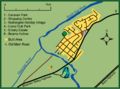
Hadspen
Location in Tasmania
|
|||||||||
| Population | 2,275 (2016 census) | ||||||||
| Established | 1866 | ||||||||
| Postcode(s) | 7290 | ||||||||
| Elevation | 142 m (466 ft) | ||||||||
| Location | 8 km (5 mi) SW of Launceston | ||||||||
| LGA(s) | Meander Valley Council | ||||||||
| State electorate(s) | Lyons | ||||||||
| Federal Division(s) | Lyons | ||||||||
|
|||||||||
Hadspen is a small town in northern Tasmania, Australia. It sits on the South Esk River, about 8 kilometres (5.0 mi) southwest of Launceston. Hadspen is mostly a place where people live, acting like a suburb for Launceston. Most buildings are homes and were built recently.
The town's population is just over 2,000 people. It has grown a lot since the 1960s, when only a few hundred lived there. There are plans for Hadspen to get even bigger in the future.
People started settling here in the early 1800s. It began as a few houses near a river crossing that often flooded. Over time, bridges were built in the same spot. Hadspen was officially named a town in 1866. It used to be on the main road to Devonport, but a new road bypassed the town center later on. Hadspen once had schools, but none are left today.
The town has some very old buildings, including some from colonial times. The most famous is Entally House, built in 1819. It was the home of Thomas Reibey, who became the Premier of Tasmania. The Red Feather Inn, built in the 1840s, is still used as a restaurant and for lodging. A old jail from the same time shows Tasmania's convict history. The Uniting Church building is over 150 years old. The Anglican Church of the Good Shepherd took more than ninety years to finish.
Contents
Where is Hadspen Located?
Hadspen is about 142 metres (466 ft) above sea level. It is located 8 kilometres (5.0 mi) southwest of Launceston, Tasmania. The town is on the south side of the South Esk River. It is also close to where the South Esk and Meander Rivers meet.
The town is surrounded by beautiful countryside. You can see valleys, river flood plains, and rolling green pastures. There are also some areas of untouched bushland. Most of Hadspen is between the South Esk River and a low area called Beams Hollow.
A Look at Hadspen's Past
By 1831, a small settlement called Hadspen existed near a river crossing. This crossing was a ford on the South Esk River. A road from Launceston was planned to cross the river at this ford. It was near the property of Thomas Haydock Reibey, called Entally.
The name "Hadspen" might have come from a surveyor named George Frankland. He may have named it after Hadspen House, an estate in England. By the 1840s, Hadspen was a small group of houses near "Reibey's ford." This river crossing was now on the main road from Launceston.
The Hadspen Post Office opened in 1849. However, the town was not officially declared until January 1866. A bridge was built in the early 1840s to replace the ford, which was often too flooded to cross. Over the next century, this bridge was often repaired or replaced.
Hadspen.-This rural township, long marked out on the maps, is fast assuming the appearance of a village. It is situated close to and on this side of Reibey's Bridge. Mr. Sprunt lately obtained a licence to open an inn, which is a large and commodious brick building. Several cottages are erected, and a blacksmith's forge for the convenience of surrounding settlers will soon be at work. Abundance of excellent stone is found within a few yards of the spot, and we observe one gentleman has built a remarkably neat cottage, fronting the main street, of this material. The distance from Launceston is about eight miles, and if the road were slightly repaired the drive in this direction would be the most pleasant in the neighbourhood
—The Examiner, 22 December 1844

In its early days, Hadspen had two hotels. The Cricket Club Hotel was near the river. It was damaged by a flood in the 1870s and later torn down. The Hadspen Hotel was built by convicts using sandstone. By 1881, both hotels had closed. Today, the Rutherglen complex is the only place in town with a liquor license. There was also a brewery in Hadspen for a while, but it closed long ago.
The postal service in Hadspen started in a shop. Later, it moved to one of the hotels. By 1966, the post office was in its own building. This building was on the site of an old blacksmith's shop.
There is an early mention of churches in 1844. The Examiner newspaper noted that Bishop Nixon laid the foundation stone for a new church. This was likely a small wooden church, the first one used by the Church of England. Reverend Thomas Reibey built a small stone chapel at Entally in 1850. It was for the estate's workers but also used by some townspeople. The Uniting Church building in Hadspen's main street is a small, wooden colonial church. It was finished in July 1874 as a Wesleyan Chapel.
Schools in Hadspen's History
In 1845, local Church of England members said they had started a new school. By 1848, there was also a Wesleyan Sunday School with 20 students. By 1867, Hadspen had a state school. However, it often lacked money and was closed for at least two years. This school never became very big. In 1903, it had an average of 20 students.
The school was still open in 1937. But people were asking for regular transport to take children to Hagley District School. This was because the Hadspen school was going to close. Children from Hadspen started going to the Hagley school in March 1938. By the middle of that year, school transport was approved. This transport also served students from nearby Carrick.
The Hadspen school building was eventually moved. In 1944, it was taken down and rebuilt in Falmouth. Schools also ran in other town buildings. These included a hall near the Anglican church and what is now the Uniting Church. Today, there are no schools left in Hadspen.
Who Lives in Hadspen?
Hadspen was a small town for most of its early history. In 1966, its population was only 311 people. It grew quickly from the 1970s to the 1990s. This happened after new housing areas were built. During this time, the population doubled.
In 2001, 29% of Hadspen's population was under 14 years old. This was one of the highest percentages in Tasmania. Future growth means the town is expected to need a primary school. The population grew from 1,334 in 1991 to 2,063 in 2011. The Meander Valley Council expects Hadspen's population to double in the next two decades.
Most of Hadspen's residents are Australian-born, over 90% in 2011. This is much higher than the Australian average. In almost all homes (96.9%), only English is spoken. This also contrasts with the Australian average. The average income in Hadspen is slightly higher than the country's average. The unemployment rate is also a bit lower.
Getting Around Hadspen
Hadspen was an important stop for coaches from Launceston to Deloraine. This was true from at least the 1840s. Coach services became less popular when trains started running in Tasmania in the late 1860s. The government began running a school bus from Hadspen to Hagley in the 1930s.
The Meander Valley Highway, once called Bass Highway, now goes around the old main street. The Bass Highway connects Launceston, Burnie, and Devonport. It branches off east of Hadspen and passes south of the town.
Today, Hadspen has three bus services. Redline Coaches runs a daily school bus to schools in and around Launceston. Westbus, another company, takes students to Hagley Farm School and Westbury Primary School. Metro Tasmania's public bus service connects Hadspen to the center of Launceston.
Sports and Recreation
Cricket has been played in Hadspen since at least the 1860s. Games took place at Entally and grounds closer to town. The cricket oval at Entally was one of the first in Australia. Famous English cricketer W. G. Grace played there in 1874. Besides cricket, Entally's grounds were often used for picnics and big annual events.
The Hadspen Chieftains cricket club started in 1987–88. They play in the Northern Tasmania Cricket Association. They won championships in the 1991–92 and 1993–94 seasons. They also won the Charltons Cup Premiership in 1993–94 and 1994–95.
Entally House also has a history with horse racing. Thomas Reibey was very interested in it. For a while, horse races were held at Entally Park. About 90 horses were raced from Entally's stables. Two of them became very famous. Stockwell came second in the Melbourne Cup in 1881. Malua, called the "greatest horse of all time" by the Sydney Bulletin, won the Melbourne Cup in 1884.
Historic Buildings of Hadspen
Hadspen has many buildings that are still mostly original from colonial times. Some date back to the early 1800s. The Red Feather Inn, a nearby convict-era jail, and four cottages form a group of historic buildings in the town center. The jail is made of sandstone and was used to hold convicts overnight. The inn, jail, and St Andrew's church are all listed on the Tasmanian Heritage Register. This means they are important to Tasmania's history.
Entally House: A Historic Estate

Entally House is a historic property on the western bank of the South Esk River. It is the only part of Hadspen on that side of the river. Entally sits on 85 acres (34 ha) of land. It includes a large colonial house, stables, a chapel, and vineyards. The buildings are filled with furniture and art from the 1800s. You can even see old carriages in the coach house.
Thomas Reibey, a settler, built the first house in 1819. It was a single-story building with two square towers for defense. Over time, it was greatly expanded. When Thomas Haydock Reibey died in 1842, his son, Thomas Reibey, inherited Entally. This younger Thomas Reibey became a leading figure in the Anglican Church and later the Premier of Tasmania.
Thomas Reibey built a private chapel at Entally. He was very interested in horse racing and hunting. Deer and horses were bred at Entally. At least 90 horses raced from Entally's stables, including the famous "Stockwell" and Malua. By 1883, Entally's library was said to be the biggest in the colony. The lawn was often used for picnics and cricket matches.
After Thomas Reibey died in 1912, the property left the family's hands. In 1948, the land and buildings were bought by the Scenery Preservation Board. It was saved as a "historic site" for its value as a colonial home. Since then, the house has been restored and filled with period furniture. Today, it is managed by volunteers.
The Church of the Good Shepherd

An Anglican church was planned for Hadspen in the late 1850s. Thomas Reibey hired architects from London to design it in 1857. The church's design was based on an English church. It was to be built with blue ironstone walls and freestone decorations. The foundation stone was laid in December 1868. Construction began with local stonework.
Thomas Reibey was paying for all the construction. However, work stopped in 1870 due to personal difficulties and financial challenges. By then, the walls were unfinished, and the building had no roof. Even though the church was incomplete, both Reibey and his wife Catherine were buried in a graveyard behind the building.
The church remained unfinished for over ninety years. By 1957, Anglican services were held in a wooden church next to the unfinished building. People became interested in finishing the old church. In April 1957, a gathering was held in the unfinished building to bless its completion.
The original architect's plans were saved and mostly followed. A builder from Launceston was hired, but volunteers did much of the work. The church was finally completed on May 20, 1961. The first service was held the next day. Some items in the church came from Entally's Chapel, including the altar and a bell. A stained glass window at the back of the church also came from Entally's chapel. It shows the crucifixion of Jesus and the Good Shepherd. The church was officially dedicated in February 1973.
The Red Feather Inn
The Red Feather Inn is a historic building on Hadspen's main street. It was built as a coaching inn, a place where coaches would stop and travelers could rest. Today, it is used as a restaurant and for accommodation. The front of the building is a large, single-story sandstone structure. Because the land slopes, the back of the building has two stories.
In the 1840s, more people had money, which helped the coach transport business grow. When it was built in 1842, the Red Feather Inn was the first stop for changing horses on the road from Launceston to Deloraine. It was one of the earliest coaching inns in the colony. It was built by John Sprunt using sandstone blocks cut by convicts.
The inn first opened in 1844 and was successful at first. But its success declined when a train line was built from Launceston in 1869. Train travel took away passengers and goods, reducing the need for coaching inns. This led to less traffic and business in Hadspen. As of 2004, it was a restaurant. After a renovation in 2008, it also offered accommodation and a cooking school.
Bridges Over the River

Flooding of the South Esk River has always affected transport in Hadspen. The South Esk River separates the town from areas to the west. Very high floods can also cut off the highway east of town at Beams Hollow. The river was first crossed by a ford called "Reibey's Ford" near Entally House. This ford was often too flooded to cross, forcing people to take long detours. Thomas Haydock Reibey put a punt (a flat-bottomed boat) at the crossing in 1828. He was allowed to charge a fee for its use.
In 1836, plans were made to build a bridge at Hadspen. Five years later, the government passed an act to help build the bridge. The government paid some of the cost, and Thomas Haydock Reibey paid the rest. To get his money back, Reibey was allowed to charge a toll. The wooden bridge was finished by November 1843. It was known as "Reibey's Bridge." It was narrow, only fitting one wagon at a time, and had only a single chain on each side for safety. This led to at least one valuable horse being lost.

The bridge became known for being unsafe. A new bridge, 3 feet (1 m) higher, was being built in 1878. This new wooden bridge stood on stone piers. Floods continued to cover Hadspen's only bridge. In 1893, floods may have been 8 feet (2.4 m) above the road leading to the bridge. Both the bridge and roads were badly damaged.
By 1911, a steel bridge crossed the river at the same spot. This new bridge had concrete supports and a wooden roadway. In March of that year, floods covered it by about 10 feet (3.0 m). Five of the bridge's seven sections were swept away. The bridge was repaired later that year and lasted for another fifty years. Over time, especially after floods, people asked for the bridge to be raised.
The last and newest bridge was built as part of a bypass around Hadspen's center. By 1978, the Bass Highway crossed the river further upstream. The old main road was no longer a main route. This bridge is a 240 metres (790 ft) long concrete structure with two lanes.
Hadspen Today

Hadspen is a small town that mostly serves as a "dormitory suburb." This means many people live there but work in nearby Launceston. Entally House is on the west side of town, across the river. Hadspen has a small shopping center with a post office and a service station. Next to it is a large caravan and cabin park.
Most of the new buildings have been homes, mainly on the north side of the Meander Valley Highway. Over 13 hectares (32 acres) of land was already set aside for development in 2005. The council plans to allow more expansion south of the Highway.
The town is part of the Meander Valley Council local government area. It is also in the federal and state electoral Division of Bass. For the Tasmanian Legislative Council, it is in the Western Tiers division.
Hadspen has grown without much space set aside for small businesses. This is why there is only one main shopping complex. There used to be another service station, but it closed in 2008. Rutherglen is a holiday village, conference center, and retirement village on the west side of town. It is the only place in Hadspen with a general liquor license. Hadspen has access to town water and sewerage systems. The town's wastewater has been treated at a plant near Carrick since the mid-1970s.
Images for kids
-

19th-century buildings in Hadspen's main street
-
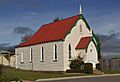
Hadspen's Uniting Church, built in 1874
-
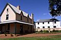
Part of Entally's main house and the stables
-
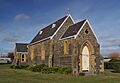
Anglican Church of the Good Shepherd in 2012
-

Site of Reibey's Ford and subsequent bridges
-
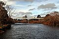
Meander Valley highway's bridge over the South Esk at Hadspen, 2012
-
Hadspen as of 2012
