Hail Storm Hill facts for kids
Quick facts for kids Hail Storm Hill |
|
|---|---|

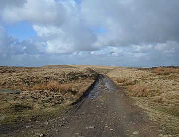
The Pennine Bridleway just to the north of the summit
|
|
| Highest point | |
| Elevation | 477 m (1,565 ft) |
| Prominence | 244 m (801 ft) |
| Parent peak | Boulsworth Hill |
| Listing | Marilyn |
| Geography | |
|
Lua error in Module:Location_map at line 420: attempt to index field 'wikibase' (a nil value).
|
|
| Location | Lancashire, England |
| OS grid | SD835193 |
| Topo map | OS Landranger 103 |
Hail Storm Hill, also called Cowpe Moss, is a tall hill in England. It is the highest point in the Rossendale Valley. This area is full of moorland and hills. It sits between the West Pennine Moors and the South Pennines.
Hail Storm Hill is completely inside Lancashire. However, the border of the Metropolitan Borough of Rochdale is very close. It passes just one kilometre (about half a mile) south-east of the top.
A large wind farm called Scout Moor Wind Farm now covers parts of Hail Storm Hill.
Exploring Hail Storm Hill
This hill is a great place for an adventure! There are a few ways to reach the top. You can enjoy amazing views from the summit.
Routes to the Top
The quickest way to climb Hail Storm Hill is from the village of Cowpe. This village is just north of the hill.
- The journey there and back is a bit over two miles (3 kilometres).
- You will climb about 600 feet (180 metres) on this route.
Another way to start your climb is from the A680 road. This road is at Turf Moor to the south-west.
- This path is about 3.5 miles (5.6 kilometres) long.
- You will climb about 500 feet (150 metres) on this route.
You can also climb the hill from Rawtenstall. This town is to the north-west.
Walking Trails Around the Hill
Several long-distance walking paths cross near Hail Storm Hill. These paths are perfect for longer hikes.
- The Pennine Bridleway goes just north of the summit.
- The Rossendale Way crosses the western side of the hill.
- The Rochdale Way passes over Knowl Moor. This is about two miles (3 kilometres) to the south.
 | John T. Biggers |
 | Thomas Blackshear |
 | Mark Bradford |
 | Beverly Buchanan |

