Haleakalā facts for kids
Quick facts for kids Haleakalā |
|
|---|---|
| East Maui Volcano | |
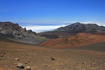
Haleakalā crater
|
|
| Highest point | |
| Elevation | 10,023 ft (3,055 m) |
| Prominence | 10,023 ft (3,055 m) |
| Isolation | 76 mi (123 km) |
| Listing |
|
| Geography | |
| Location | Maui, Hawaii, U.S. |
| Parent range | Hawaiian Islands |
| Topo map | USGS Kilohana (HI) |
| Geology | |
| Age of rock | <1.0 Ma, Pleistocene epoch |
| Mountain type | Shield volcano |
| Last eruption | between 1480 and 1600 |
| Climbing | |
| Easiest route | paved highway |
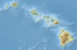
Haleakalā is a giant, active shield volcano that makes up more than 75% of the Hawaiian island of Maui. It's also known as the East Maui Volcano. The western part of Maui is formed by another volcano called Mauna Kahalawai.
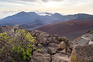
The highest point of Haleakalā is Puʻu ʻUlaʻula (Red Hill), which stands at 10,023 feet (3,055 meters) tall. From the top, you can look down into a huge bowl-shaped area. This area is about 11.25 miles (18 km) across, 3.2 miles (5 km) wide, and nearly 800 meters (2,600 feet) deep. It has steep walls and many small volcanic hills inside.
Contents
The Story of Haleakalā
Long ago, early Hawaiians gave the name Haleakalā to the entire mountain. This name means "house of the sun." In Hawaiian stories, the big bowl at the top of Haleakalā was home to the grandmother of the demigod Māui. Legend says that Māui's grandmother helped him catch the sun. She made the sun slow down its journey across the sky, which made the days longer.
How Haleakalā Was Formed
Haleakalā began forming about 2 million years ago. It grew into a massive shield volcano, which looks like a warrior's shield lying on the ground because of its gentle slopes.
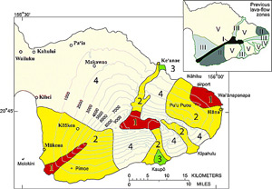
Haleakalā is still an active volcano. It has erupted many times over the last 30,000 years. Scientists believe it erupted at least once between the years 1480 and 1600. These eruptions happened along two main "rift zones," which are long cracks in the Earth's surface. These rift zones stretch from La Perouse Bay in the southwest, through the Haleakalā summit, and all the way to Hāna in the east.
The large bowl at the summit of Haleakalā is not a typical volcanic crater. Instead, it formed when the tops of two huge valleys eroded over time and joined together. These valleys created two large openings, Koʻolau on the north side and Kaupō on the south side.
Understanding Volcanic Activity
Scientists at the U.S. Geological Survey keep a close watch on Haleakalā. They use a system to rate how dangerous lava flows might be. While some Hawaiian volcanoes like Kilauea and Mauna Loa erupt very often, Haleakalā erupts less frequently.
Haleakalā has erupted about three times in the last 900 years. Because it erupts less often and its lava flows cover smaller areas, it is considered a moderate hazard compared to some other active volcanoes in Hawaii. As of September 2025, the volcano alert level for Haleakalā is "normal." This means it is in a typical, non-eruptive phase.
Amazing Animals and Plants
Haleakalā is home to many unique creatures and plants, some of which are found nowhere else on Earth!
The Nēnē Bird
The nēnē bird is Hawaii's state bird and is an endangered species. It used to live on all the Hawaiian islands. Now, you can only find it on the islands of Hawaiʻi, Maui, Molokaʻi, and Kauaʻi. Losing their homes and being hunted, along with new animals brought to the islands, caused their numbers to drop. Special programs are helping to increase the nēnē population.
The Silversword Plant
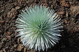
The Haleakalā silversword is a very special plant. It grows only on the slopes of Haleakalā. This plant is threatened by warmer temperatures and less rain due to climate change. Park rangers have put up fences to protect these fragile plants from animals that might eat them and from visitors who might accidentally damage them.
Forest Birds and Mosquitoes
Several native forest birds in Hawaii are almost gone. This includes the kiwikiu and ʻākohekohe, which live only in East Maui. Their populations have dropped a lot. A big problem for these birds is diseases carried by mosquitoes, like avian malaria.
Scientists are working hard to protect these birds. They are using a clever method called the "incompatible insect technique." They release male southern house mosquitoes that carry special Wolbachia bacteria. When these males mate with female mosquitoes, their eggs don't hatch. This helps to reduce the number of mosquitoes that can spread diseases to the birds. By June 2024, millions of these special mosquitoes had been released on the mountain.
Tiny Creatures of Haleakalā
Haleakalā is also home to many small creatures without backbones, called invertebrates. These include snails, spiders, moths, and flies. Many species, like some snails, live in the rainforests around the mountain. Others live in the cooler, higher areas with shrubs and rocky ground. The Haleakalā flightless moth is a unique insect found only in the alpine area at the summit. Yellow-faced bees, known as Nalo Meli Maoli in Hawaiian, live in most of the mountain's different habitats.
Exploring Haleakalā Today
Haleakalā National Park
The area around and including the summit of Haleakalā is part of Haleakalā National Park. This park covers about 30,183 acres (122 km²). It includes the summit, Kipahulu Valley, and the beautiful ʻOheʻo Gulch (with its pools) that reaches the ocean.
There are two main trails that lead into the Haleakalā summit area: the Sliding Sands Trail and the Halemauʻu Trail. The temperature near the summit can be cool, usually between 40 and 60°F (4 and 16°C). The air is also thinner at this high elevation. Because the trails go downhill into the crater, hikers face a challenging climb back up. Even so, many people love to visit Haleakalā, especially to see the amazing sunrise from the summit or the visitor center just below it. If you want to see the sunrise, you need to make a reservation to enter the park between 3:00 AM and 7:00 AM.
Stargazing and Science
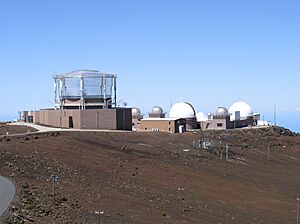
The summit of Haleakalā is one of the best places in the world for telescopes. This is because the air is incredibly clear, dry, and still. There are also no bright city lights nearby to block the view of the stars.
Because of these perfect conditions, experts from all over the world come to "Science City." This is a special complex with many telescopes. Different groups, including the U.S. Department of Defense and the University of Hawaii, work together here. Some telescopes study space, while others track man-made objects like spacecraft and satellites.
Getting Around the Mountain
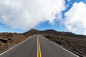
A well-maintained road called Haleakalā Highway leads all the way to the peak. It was finished in 1935 and has many winding turns. You can drive your own car (though some parts are restricted) or take a tour with one of the companies that operate in the park.
Cycling down the mountain is also a popular activity. For safety reasons, commercial bike tours now start outside the National Park boundary, at about 6,500 feet (1,980 meters) altitude. This allows riders to enjoy the thrilling descent safely. Horseback riding is another fun way to explore the park.
Weather on Haleakalā
The summit of Haleakalā has a cool-summer Mediterranean climate. This is a rare type of climate. Lower down, at the Haleakalā Ranger Station, the climate is a subtropical highland type.
Temperatures at the summit usually range between 40 and 60°F (4 and 16°C). It can get quite chilly, especially in the early mornings or evenings.
| Climate data for Haleakalā Ranger Station 6,962 ft (2,122 m) asl. (1991–2020 normals, extremes 1940–present) | |||||||||||||
|---|---|---|---|---|---|---|---|---|---|---|---|---|---|
| Month | Jan | Feb | Mar | Apr | May | Jun | Jul | Aug | Sep | Oct | Nov | Dec | Year |
| Record high °F (°C) | 78 (26) |
76 (24) |
78 (26) |
79 (26) |
78 (26) |
78 (26) |
80 (27) |
78 (26) |
78 (26) |
80 (27) |
76 (24) |
74 (23) |
80 (27) |
| Mean maximum °F (°C) | 68.6 (20.3) |
67.5 (19.7) |
67.2 (19.6) |
67.8 (19.9) |
70.3 (21.3) |
72.2 (22.3) |
72.6 (22.6) |
73.0 (22.8) |
70.1 (21.2) |
70.4 (21.3) |
69.7 (20.9) |
69.4 (20.8) |
74.6 (23.7) |
| Mean daily maximum °F (°C) | 61.0 (16.1) |
59.7 (15.4) |
59.7 (15.4) |
60.7 (15.9) |
63.2 (17.3) |
65.6 (18.7) |
65.5 (18.6) |
66.1 (18.9) |
64.7 (18.2) |
64.0 (17.8) |
63.1 (17.3) |
61.1 (16.2) |
62.9 (17.2) |
| Daily mean °F (°C) | 52.5 (11.4) |
51.2 (10.7) |
51.4 (10.8) |
52.2 (11.2) |
54.6 (12.6) |
56.6 (13.7) |
57.2 (14.0) |
57.7 (14.3) |
56.3 (13.5) |
55.9 (13.3) |
55.0 (12.8) |
53.1 (11.7) |
54.5 (12.5) |
| Mean daily minimum °F (°C) | 43.9 (6.6) |
42.7 (5.9) |
43.1 (6.2) |
43.8 (6.6) |
45.9 (7.7) |
47.7 (8.7) |
48.9 (9.4) |
49.4 (9.7) |
47.9 (8.8) |
47.8 (8.8) |
47.0 (8.3) |
45.1 (7.3) |
46.1 (7.8) |
| Mean minimum °F (°C) | 37.3 (2.9) |
36.5 (2.5) |
36.7 (2.6) |
38.5 (3.6) |
40.0 (4.4) |
42.2 (5.7) |
42.8 (6.0) |
43.2 (6.2) |
42.7 (5.9) |
42.6 (5.9) |
41.0 (5.0) |
39.1 (3.9) |
34.4 (1.3) |
| Record low °F (°C) | 29 (−2) |
27 (−3) |
30 (−1) |
31 (−1) |
32 (0) |
33 (1) |
32 (0) |
33 (1) |
35 (2) |
31 (−1) |
29 (−2) |
30 (−1) |
27 (−3) |
| Average precipitation inches (mm) | 5.14 (131) |
4.08 (104) |
5.70 (145) |
2.75 (70) |
2.44 (62) |
1.62 (41) |
2.70 (69) |
2.17 (55) |
2.53 (64) |
3.25 (83) |
4.59 (117) |
5.28 (134) |
42.25 (1,073) |
| Average precipitation days (≥ 0.01 in) | 9.3 | 8.8 | 12.9 | 12.1 | 9.3 | 8.6 | 10.7 | 10.7 | 12.1 | 11.5 | 12.3 | 11.8 | 130.1 |
| Source: NOAA | |||||||||||||
| Climate data for Haleakalā Summit 338 (1971–2000 normals) | |||||||||||||
|---|---|---|---|---|---|---|---|---|---|---|---|---|---|
| Month | Jan | Feb | Mar | Apr | May | Jun | Jul | Aug | Sep | Oct | Nov | Dec | Year |
| Record high °F (°C) | 69 (21) |
69 (21) |
67 (19) |
68 (20) |
70 (21) |
73 (23) |
66 (19) |
70 (21) |
68 (20) |
68 (20) |
65 (18) |
69 (21) |
73 (23) |
| Mean daily maximum °F (°C) | 45.2 (7.3) |
49.9 (9.9) |
50.9 (10.5) |
52.2 (11.2) |
54.7 (12.6) |
58.3 (14.6) |
57.7 (14.3) |
58.5 (14.7) |
57.6 (14.2) |
56.8 (13.8) |
50.5 (10.3) |
42.8 (6.0) |
53.1 (11.7) |
| Mean daily minimum °F (°C) | 33.6 (0.9) |
36.1 (2.3) |
36.5 (2.5) |
37.4 (3.0) |
39.1 (3.9) |
42.1 (5.6) |
41.8 (5.4) |
42.3 (5.7) |
42.1 (5.6) |
41.3 (5.2) |
37.6 (3.1) |
31.8 (−0.1) |
38.6 (3.7) |
| Record low °F (°C) | 20 (−7) |
15 (−9) |
20 (−7) |
21 (−6) |
31 (−1) |
30 (−1) |
28 (−2) |
30 (−1) |
25 (−4) |
26 (−3) |
29 (−2) |
22 (−6) |
15 (−9) |
| Average precipitation inches (mm) | 8.00 (203) |
3.57 (91) |
3.05 (77) |
4.00 (102) |
1.35 (34) |
0.37 (9.4) |
0.47 (12) |
1.11 (28) |
1.59 (40) |
1.32 (34) |
4.09 (104) |
4.67 (119) |
33.59 (853) |
| Average snowfall inches (cm) | 0.0 (0.0) |
0.2 (0.51) |
0.0 (0.0) |
0.0 (0.0) |
0.0 (0.0) |
0.0 (0.0) |
0.0 (0.0) |
0.0 (0.0) |
0.0 (0.0) |
0.0 (0.0) |
0.0 (0.0) |
0.0 (0.0) |
0.2 (0.51) |
| Source: Western Regional Climate Center | |||||||||||||
See also
 In Spanish: Haleakala para niños
- List of mountain peaks of the United States
- List of volcanoes of the United States
- List of Ultras of Oceania
- List of Ultras of the United States
- Hawaii hotspot
- Evolution of Hawaiian volcanoes
- Hawaiian–Emperor seamount chain
- Haleakalā Wilderness
 | Delilah Pierce |
 | Gordon Parks |
 | Augusta Savage |
 | Charles Ethan Porter |


