
Hardy Bridge facts for kids
Quick facts for kids Hardy Bridge |
|
|---|---|

Crosses the Missouri River
|
|
| Coordinates | 47°10′01″N 111°50′02″W / 47.167°N 111.834°W |
| Carries | Two (2) lanes of Old |
| Crosses | Missouri River |
| Locale | Milepost 6, Old U.S. Route 91, 14 miles (23 km) southwest of Cascade, Montana, U.S. |
| Maintained by | Montana Department of Transportation |
| Characteristics | |
| Design | Warren through truss |
| Total length | 550 feet (170 m) |
| Width | 21 feet (6.4 m) |
| Longest span | 21 feet (6.4 m) |
| Clearance below | 24 feet (7.3 m) |
| History | |
| Designer | Montana State Highway Commission |
| Opened | 1931 |
| Statistics | |
| Daily traffic | 100 per day (estimated 2002) |
| Toll | None |
|
Hardy Bridge
|
|

Location in Montana

Location in the United States
|
|
| Location | Milepost 6, Old U.S. Route 91, 14 miles (23 km) southwest of Cascade, Montana, U.S. |
|---|---|
| Built | 1931, 95 years ago |
| Architect | Montana State Highway Commission |
| NRHP reference No. | 09001180 |
| Added to NRHP | January 4, 2010 |
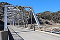
The Hardy Bridge is a special kind of bridge in the western United States. It's called a "Warren through truss" bridge. This means it has a strong metal framework that goes above the road.
This bridge has three sections and two lanes for cars. It crosses the Missouri River in Montana. You can find it about 14 miles (22.5 km) southwest of Cascade, Montana. This area is also southwest of Great Falls, Montana.
The Hardy Bridge was built in 1931. It was one of many bridges built during a time when Montana was greatly expanding its roads. Because of its importance, it was added to the National Register of Historic Places on January 4, 2010.
The bridge gets its name from a small community called Hardy. This community is about 2 miles (3.2 km) downstream from the bridge. The bridge is in a cool area called the Adel Mountains Volcanic Field. This area has amazing rock formations from an old volcano. The river here is about 3,400 feet (1,036 meters) above sea level.
Contents
About the Hardy Bridge
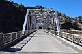
This bridge is free to use, meaning there are no tolls. It is about 550 feet (167.6 meters) long and 21 feet (6.4 meters) wide. It carries two lanes of traffic, but there are no shoulders for cars to pull over.
The longest part of the bridge is 21 feet (6.4 meters) long. The main parts of the bridge are made of strong steel. The road itself is made of concrete poured right on the spot. Cars have about 14.2 feet (4.3 meters) of space to drive under the top of the bridge. The bridge also goes over the BNSF Railway tracks, with 24 feet (7.3 meters) of space above them.
The most important part of the bridge is its steel framework, called trusses. There are two long trusses, each about 198 feet (60.3 meters) long. There is also one shorter truss, about 120 feet (36.6 meters) long. These trusses are made of steel beams connected with special plates.
Three strong concrete supports, called piers, hold up the bridge. Two piers are on land at each end. The middle pier stands in the river. The bridge was last checked in September 2010. Inspectors found it to be in good condition.
In 2002, about 100 vehicles used the bridge each day. Only a small number of these were big trucks. Not many more cars are expected to use it in the future.
How the Bridge Came to Be
Early Roads and Railways
Back in 1860, a U.S. Army officer named John Mullan built the first major road in this area. It connected Fort Benton, Montana, to Fort Walla Walla, Washington. This road, called the Mullan Road, helped people travel across the region.
Later, in 1865, a company built a toll road along part of the Mullan Road. This new road, called the "Benton Road," became very popular. It helped connect towns like Helena and Great Falls.
Then, in 1887, the Montana Central Railway started running trains. This railway mostly followed the path of the Benton Road. It helped connect important mining towns like Butte with other cities. After the railway was built, Cascade County made a dirt road next to the train tracks. They also built a wooden bridge over the Missouri River at Hardy.
Upgrading U.S. Route 91
When the Ford Model T car came out in 1908, more people could afford cars. But there weren't many good roads for long trips. So, in the early 1910s, people wanted to build a paved highway. This highway would connect Yellowstone National Park and Glacier National Park. This idea helped encourage tourism.
By 1919, the first "Geysers-to-Glaciers Highway" opened. This road helped connect the two big national parks. Later, in 1920, an even shorter route opened.
In 1924, a group called the American Association of State Highway Officials (AASHO) started numbering America's main roads. By 1925, the highway from Great Falls to Helena became part of U.S. Route 91. This was a very long highway that went through many states, all the way to California.
In the 1920s, Montana's roads and bridges were not very good. So, the state started a big project to improve them. They built over 400 new bridges by 1930. To save money, they started using a standard design for steel bridges.
When the Great Depression started in 1929, the state needed to save even more money. They made bridge designs simpler and cheaper to build. This also helped create jobs for more people.
Building the Hardy Bridge
The Hardy Bridge was built because U.S. Route 91 was changed. In the late 1920s, the government decided to make the route shorter. The new route would follow the Missouri River through a beautiful area called Wolf Creek Canyon. The old county road would be made wider and paved.
Building a new bridge at Hardy was a very important part of this new route. The state of Montana paid for the entire bridge. No federal money was used.
The company chosen to build the bridge was McGuire and Blakeslee from Great Falls. They were one of the few companies in Montana that knew how to build with concrete and steel. The construction contract was given on July 16, 1930.
The company bid $112,993 to build the bridge. They bought steel from the Minneapolis-Moline Power Implement Company. Cement came from the Ideal Cement Company. The Great Northern Railway also paid some money to have the bridge go over its tracks. The Hardy Bridge was finished and opened in 1931.
Later Years of the Bridge
During World War II, the U.S. government needed to identify important highways for defense. U.S. Route 91, including the Hardy Bridge, was chosen as a critical route. It helped connect copper mines in Butte to a refinery and Malmstrom Air Force Base in Great Falls.
After the war, the government wanted to build a system of superhighways like the ones in Germany. In 1956, President Dwight Eisenhower signed a law to build these "interstate highways."
Interstate 15 was planned to follow U.S. Route 91 north of Helena. By the mid-1960s, the section through Wolf Creek Canyon was finished. Building Interstate 15 meant that the Hardy Bridge was no longer on the main highway. This left the bridge much less used.
As of 2009, the Hardy Bridge was still in its original spot. The area around it hasn't changed much. The bridge's original parts are still in good condition.
Why the Hardy Bridge is Important
The Hardy Bridge was one of the last bridges of its kind built in Montana for many years. After it was finished, state engineers changed their designs. They started building simpler, cheaper bridges. This was partly because of the Great Depression. These new designs also allowed more unskilled workers to be hired.
The Hardy Bridge was also one of the last bridges in Montana built only with state money. Soon after, the federal government started providing more money for bridge building. This was part of an effort to help the economy during the Depression.
Gallery
-
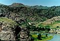
The Hardy Bridge is located in the spectacular Adel Mountains Volcanic Field.
-
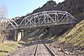
The north end of the Hardy Bridge passes over the BNSF Railway tracks.
-
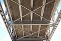
The simple substructure of the Hardy Bridge shows the cast-in-place concrete deck
-
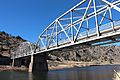
Hardy Bridge is a three-span, two-lane bridge over the Missouri River in Montana.
-
Hardy Bridge is a three-span, two-lane bridge over the Missouri River in Montana.
-
Hardy Bridge is a three-span, two-lane bridge over the Missouri River in Montana.


