
Harvey Cedars, New Jersey facts for kids
Quick facts for kids
Harvey Cedars, New Jersey
|
||
|---|---|---|
|
Borough
|
||
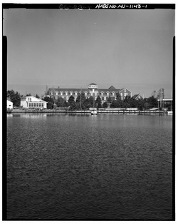
The Harvey Cedars Hotel, on Long Beach Island
|
||
|
||

Location of Harvey Cedars in Ocean County highlighted in red (right). Inset map: Location of Ocean County in New Jersey highlighted in orange (left).
|
||

Census Bureau map of Harvey Cedars, New Jersey
|
||

Harvey Cedars, New Jersey
Location in Ocean County, New Jersey

Harvey Cedars, New Jersey
Location in New Jersey

Harvey Cedars, New Jersey
Location in the United States
|
||
| Country | ||
| State | ||
| County | ||
| Incorporated | November 20, 1894 | |
| Government | ||
| • Type | Walsh Act | |
| • Body | Board of Commissioners | |
| Area | ||
| • Total | 1.19 sq mi (3.08 km2) | |
| • Land | 0.56 sq mi (1.45 km2) | |
| • Water | 0.63 sq mi (1.62 km2) 52.61% | |
| Area rank | 488th of 565 in state 23rd of 33 in county |
|
| Elevation | 3 ft (0.9 m) | |
| Population
(2020)
|
||
| • Total | 391 | |
| • Estimate
(2023)
|
397 | |
| • Rank | 558th of 565 in state 32nd of 33 in county |
|
| • Density | 696.7/sq mi (269.0/km2) | |
| • Density rank | 420th of 565 in state 24th of 33 in county |
|
| Time zone | UTC−05:00 (Eastern (EST)) | |
| • Summer (DST) | UTC−04:00 (Eastern (EDT)) | |
| ZIP Code |
08008
|
|
| Area code(s) | 609 exchanges: 207, 361, 492, 494 | |
| FIPS code | 3402930390 | |
| GNIS feature ID | 0885246 | |
Harvey Cedars is a small town, called a borough, located right on the coast of New Jersey. It's part of Ocean County and sits on a thin strip of land called Long Beach Island. This island has the Atlantic Ocean on one side and Barnegat Bay on the other.
In 2020, about 391 people lived in Harvey Cedars. This was the highest number of people recorded living there during a census! The town was officially created on December 15, 1894. Before that, its post office was called High Point, but the name was changed in the 1930s to avoid confusion with another High Point in New Jersey.
Many of the homes in Harvey Cedars are used only during the summer. This means the population can jump to about 12,000 people in the warmer months! Because it's a quiet place with easy access to both the bay and the ocean, houses here can be quite expensive.
Contents
History of Harvey Cedars
Before buildings covered Long Beach Island, the northern part of the island was full of Atlantic white cedar trees. Early settlers in the area made a living by collecting salt hay and seaweed.
The first time this area was mentioned in writing was in a deed from 1751. It was called "Harvest Quarters." The name "Harvey Cedars" likely comes from these "harvest" homes used by farmers and the many "cedars" (trees) that grew there.
Geography and Location
Harvey Cedars covers about 1.19 square miles (3.08 square kilometers). A little more than half of this area is land, and the rest is water.
One small area within the borough is known as High Point. Harvey Cedars shares its borders with other towns in Ocean County, including Barnegat Township, Long Beach Township, and Stafford Township.
Population Changes Over Time
| Historical population | |||
|---|---|---|---|
| Census | Pop. | %± | |
| 1900 | 39 | — | |
| 1910 | 33 | −15.4% | |
| 1920 | 65 | 97.0% | |
| 1930 | 53 | −18.5% | |
| 1940 | 74 | 39.6% | |
| 1950 | 106 | 43.2% | |
| 1960 | 134 | 26.4% | |
| 1970 | 314 | 134.3% | |
| 1980 | 363 | 15.6% | |
| 1990 | 362 | −0.3% | |
| 2000 | 359 | −0.8% | |
| 2010 | 337 | −6.1% | |
| 2020 | 391 | 16.0% | |
| 2023 (est.) | 397 | 17.8% | |
| Population sources: 1900–2000 1900–1920 1900–1910 1910–1930 1940–2000 2000 2010 2020 |
|||
In 2010, there were 337 people living in Harvey Cedars. Most people were White (99.11%). A small number were Black or African American (0.59%) or Asian (0.30%). About 0.89% of the population was Hispanic or Latino.
The average age of people living in Harvey Cedars in 2010 was 61.6 years old. Many residents were 65 or older (41.8%).
Schools in Harvey Cedars
Students in Harvey Cedars attend public schools through two different districts.
Elementary and Middle School
For students from pre-kindergarten up to sixth grade, they go to schools in the Long Beach Island Consolidated School District. This district also serves students from nearby towns like Barnegat Light, Long Beach Township, Ship Bottom, and Surf City.
The district has two schools:
- Ethel Jacobsen School in Surf City (for pre-kindergarten to second grade).
- Long Beach Island Grade School in Ship Bottom (for grades 3–6).
High School Education
For seventh through twelfth grades, students attend schools in the Southern Regional School District. This district includes students from the Long Beach Island towns, plus Beach Haven and Stafford Township.
The schools in this district are:
- Southern Regional Middle School (for grades 7–8).
- Southern Regional High School (for grades 9–12).
Both of these schools are located in the Manahawkin section of Stafford Township.
When the Southern Regional School District started in 1957, it had a similar number of students from Long Beach Island and Stafford Township. Today, most students are from Stafford Township. The cost of sending students to these schools is shared by the towns based on their property values.
Getting Around Harvey Cedars
_at_Union_Avenue_in_Harvey_Cedars,_Ocean_County,_New_Jersey.jpg)
As of 2010, Harvey Cedars had about 9.82 miles (15.80 km) of roads. Most of these roads are maintained by the town itself.
There are no major highways like Interstates or U.S. routes that go through Harvey Cedars. The main road is County Route 607, also known as Long Beach Boulevard.
Public Transportation Options
- Ocean County Ride offers bus service on the OC9 LBI North route. This route connects Barnegat Light to Manahawkin/Stafford Township.
- The LBI Shuttle is a free bus service that runs along Long Beach Boulevard. It operates every 5 to 20 minutes from 10:00 AM to 10:00 PM. This shuttle serves many towns and communities on Long Beach Island, including Harvey Cedars.
Climate and Nature
Harvey Cedars has a humid subtropical climate. This means it has hot, somewhat humid summers and cool winters. It rains throughout the year.
In summer, a cool ocean breeze often blows in the afternoon. However, it can sometimes get very hot and humid. In winter, it can get very cold and windy. The average snowfall from November to April is about 12 to 18 inches (30 to 46 cm). February is usually the snowiest month.
| Climate data for Harvey Cedars Beach, NJ (1981–2010 Averages) | |||||||||||||
|---|---|---|---|---|---|---|---|---|---|---|---|---|---|
| Month | Jan | Feb | Mar | Apr | May | Jun | Jul | Aug | Sep | Oct | Nov | Dec | Year |
| Mean daily maximum °F (°C) | 40.2 (4.6) |
42.3 (5.7) |
49.1 (9.5) |
57.6 (14.2) |
67.9 (19.9) |
77.0 (25.0) |
82.6 (28.1) |
81.4 (27.4) |
75.6 (24.2) |
65.0 (18.3) |
55.0 (12.8) |
45.2 (7.3) |
61.7 (16.5) |
| Daily mean °F (°C) | 33.0 (0.6) |
35.1 (1.7) |
41.4 (5.2) |
50.1 (10.1) |
60.1 (15.6) |
69.4 (20.8) |
75.2 (24.0) |
74.2 (23.4) |
67.9 (19.9) |
56.8 (13.8) |
47.4 (8.6) |
37.9 (3.3) |
54.1 (12.3) |
| Mean daily minimum °F (°C) | 25.8 (−3.4) |
27.8 (−2.3) |
33.8 (1.0) |
42.6 (5.9) |
52.2 (11.2) |
61.9 (16.6) |
67.8 (19.9) |
67.0 (19.4) |
60.2 (15.7) |
48.5 (9.2) |
39.8 (4.3) |
30.6 (−0.8) |
46.6 (8.1) |
| Average precipitation inches (mm) | 3.42 (87) |
2.99 (76) |
4.15 (105) |
3.71 (94) |
3.27 (83) |
3.20 (81) |
4.07 (103) |
4.29 (109) |
3.24 (82) |
3.58 (91) |
3.34 (85) |
3.69 (94) |
42.95 (1,091) |
| Average relative humidity (%) | 66.9 | 65.0 | 63.1 | 64.8 | 67.5 | 72.0 | 70.9 | 72.8 | 71.6 | 69.9 | 68.9 | 67.8 | 68.4 |
| Average dew point °F (°C) | 23.2 (−4.9) |
24.5 (−4.2) |
29.8 (−1.2) |
38.7 (3.7) |
49.3 (9.6) |
60.0 (15.6) |
65.1 (18.4) |
64.9 (18.3) |
58.4 (14.7) |
47.1 (8.4) |
37.7 (3.2) |
28.2 (−2.1) |
44.0 (6.7) |
| Source: PRISM | |||||||||||||
| Climate data for Atlantic City, NJ Ocean Water Temperature (28 SW Harvey Cedars) | |||||||||||||
|---|---|---|---|---|---|---|---|---|---|---|---|---|---|
| Month | Jan | Feb | Mar | Apr | May | Jun | Jul | Aug | Sep | Oct | Nov | Dec | Year |
| Daily mean °F (°C) | 37 (3) |
35 (2) |
42 (6) |
48 (9) |
56 (13) |
63 (17) |
70 (21) |
73 (23) |
70 (21) |
61 (16) |
53 (12) |
44 (7) |
54 (12) |
| Source: NOAA | |||||||||||||
The natural plants in Harvey Cedars would mostly be Northern Cordgrass, which is a type of grass found in coastal areas.
Notable People from Harvey Cedars
Here are some interesting people who have lived in or are connected to Harvey Cedars:
- Francis Biddle (1886–1968): He was a very important lawyer who served as the United States Attorney General (the top lawyer for the U.S. government) from 1941 to 1945. He owned a summer home in Harvey Cedars.
- Wendy Mae Chambers (born 1953): A talented composer who creates music.
- Paul L. Gill (1894–1938): An artist who was known for his watercolor paintings and also taught art.
- Sue May Gill (1887–1989): Another artist, she was part of a group called the Philadelphia Ten.
- Leon Kelly (1901–1982): An artist famous for his work in a style called Surrealism.
See also
 In Spanish: Harvey Cedars para niños
