Ship Bottom, New Jersey facts for kids
Quick facts for kids
Ship Bottom, New Jersey
|
||
|---|---|---|
|
Borough
|
||
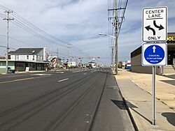
Long Beach Boulevard in Ship Bottom
|
||
|
||
| Motto(s):
"Gateway to Long Beach Island"
|
||
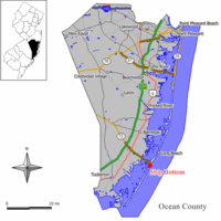
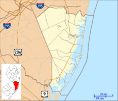
Map of Ship Bottom in Ocean County. Inset: Location of Ocean County highlighted in the State of New Jersey.
|
||
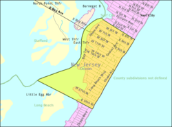
Census Bureau map of Ship Bottom, New Jersey
|
||
| Country | ||
| state | ||
| County | ||
| Incorporated | March 3, 1925 as Ship Bottom-Beach Arlington | |
| Renamed | 1947 as Ship Bottom | |
| Government | ||
| • Type | Borough | |
| • Body | Borough Council | |
| Area | ||
| • Total | 0.99 sq mi (2.58 km2) | |
| • Land | 0.71 sq mi (1.84 km2) | |
| • Water | 0.28 sq mi (0.73 km2) 28.48% | |
| Area rank | 500th of 565 in state 24th of 33 in county |
|
| Elevation | 3 ft (0.9 m) | |
| Population
(2020)
|
||
| • Total | 1,098 | |
| • Estimate
(2023)
|
1,114 | |
| • Rank | 527th of 565 in state 28th of 33 in county |
|
| • Density | 1,541.8/sq mi (595.3/km2) | |
| • Density rank | 332nd of 565 in state 17th of 33 in county |
|
| Time zone | UTC−05:00 (Eastern (EST)) | |
| • Summer (DST) | UTC−04:00 (Eastern (EDT)) | |
| ZIP Code |
08008 – Beach Haven
|
|
| Area code(s) | 609 exchanges: 207, 361, 492, 494 | |
| FIPS code | 3402967110 | |
| GNIS feature ID | 0885394 | |
Ship Bottom is a small town, called a borough, located on the famous Jersey Shore in Ocean County, New Jersey. It sits on Long Beach Island and touches the Atlantic Ocean. In 2020, about 1,098 people lived here. However, during the summer, the population can grow to as many as 20,000 visitors!
The town got its unique name from an event in March 1817. A ship had crashed and turned upside down. Rescuers saved a woman by cutting through the bottom of the ship's hull with axes. This amazing rescue gave the town its name.
Ship Bottom was first officially formed on March 3, 1925. It was called Ship Bottom-Beach Arlington and was created from parts of Long Beach Township. Later, in 1947, its name was shortened to just Ship Bottom.
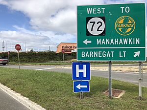
The borough is often called the "Gateway to Long Beach Island." This is because Route 72 is the only road that connects Long Beach Island to the mainland. This road crosses Manahawkin Bay over the Manahawkin Bay Bridge and ends right in Ship Bottom.
Contents
Geography of Ship Bottom
Ship Bottom covers a total area of about 0.99 square miles (2.58 square kilometers). Most of this area is land, about 0.71 square miles (1.84 square kilometers). The rest, about 0.28 square miles (0.73 square kilometers), is water.
A small area called Beach Arlington is also located within Ship Bottom. Ship Bottom shares its borders with other towns in Ocean County, including Long Beach Township, Stafford Township, and Surf City.
Population Changes Over Time
| Historical population | |||
|---|---|---|---|
| Census | Pop. | %± | |
| 1930 | 277 | — | |
| 1940 | 396 | 43.0% | |
| 1950 | 533 | 34.6% | |
| 1960 | 717 | 34.5% | |
| 1970 | 1,079 | 50.5% | |
| 1980 | 1,427 | 32.3% | |
| 1990 | 1,352 | −5.3% | |
| 2000 | 1,384 | 2.4% | |
| 2010 | 1,156 | −16.5% | |
| 2020 | 1,098 | −5.0% | |
| 2023 (est.) | 1,114 | −3.6% | |
| Population sources: 1930–2000 1930 1940–2000 2000 2010 2020 |
|||
In 2010, Ship Bottom had 1,156 people living there. The population density was about 1,620 people per square mile. The median age of residents was 54.2 years old.
Schools in Ship Bottom
Students from Ship Bottom attend public schools through two different school districts.
Elementary and Middle School
For students from pre-kindergarten up to sixth grade, they go to schools in the Long Beach Island Consolidated School District. This district also serves students from nearby towns like Barnegat Light, Harvey Cedars, Long Beach Township, and Surf City.
The district has two schools:
- Ethel Jacobsen School in Surf City: This school teaches students from pre-kindergarten to second grade.
- Long Beach Island Grade School in Ship Bottom: This school is for students in grades 3 through 6.
High School
Students in seventh through twelfth grade go to schools in the Southern Regional School District. This district includes students from the towns served by the Long Beach Island Consolidated School District, plus Beach Haven and Stafford Township.
The high school district has two schools, both located in Manahawkin:
- Southern Regional Middle School: For students in grades 7 and 8.
- Southern Regional High School: For students in grades 9 through 12.
Getting Around Ship Bottom
Ship Bottom has many roads for getting around. The town itself maintains about 13.32 miles of roads. Ocean County takes care of another 4.65 miles, and the state of New Jersey maintains 0.60 miles.
Main Roads
The main road connecting Ship Bottom to the mainland is Route 72. This highway ends in Ship Bottom and links the borough to Manahawkin in Stafford Township. It crosses the water via the Manahawkin Bay Bridge.
Public Transportation
You can also get around using public transportation.
- Ocean Ride: This local bus service has a route called OC9 Long Beach Island.
- LBI Shuttle: This free shuttle bus runs along Long Beach Boulevard. It operates every 5 to 20 minutes from 10:00 AM to 10:00 PM. It serves many towns and communities on Long Beach Island, including Ship Bottom.
Climate and Weather
Ship Bottom has a humid subtropical climate. This means it has hot, somewhat humid summers and cool winters. Rain falls throughout the year.
In summer, a cool sea breeze often blows in the afternoon. However, it can sometimes get very hot and humid. In winter, it can get very cold and windy. The average snowfall from November to April is about 12 to 18 inches. February is usually the snowiest month.
| Climate data for Ship Bottom Beach, NJ (1981–2010 Averages) | |||||||||||||
|---|---|---|---|---|---|---|---|---|---|---|---|---|---|
| Month | Jan | Feb | Mar | Apr | May | Jun | Jul | Aug | Sep | Oct | Nov | Dec | Year |
| Mean daily maximum °F (°C) | 40.2 (4.6) |
42.4 (5.8) |
49.2 (9.6) |
57.7 (14.3) |
68.0 (20.0) |
77.2 (25.1) |
82.6 (28.1) |
81.4 (27.4) |
75.5 (24.2) |
64.9 (18.3) |
54.9 (12.7) |
45.1 (7.3) |
61.7 (16.5) |
| Daily mean °F (°C) | 33.1 (0.6) |
35.2 (1.8) |
41.6 (5.3) |
50.3 (10.2) |
60.3 (15.7) |
69.6 (20.9) |
75.3 (24.1) |
74.3 (23.5) |
67.9 (19.9) |
56.8 (13.8) |
47.5 (8.6) |
37.9 (3.3) |
54.2 (12.3) |
| Mean daily minimum °F (°C) | 26.0 (−3.3) |
28.0 (−2.2) |
33.9 (1.1) |
42.9 (6.1) |
52.5 (11.4) |
62.1 (16.7) |
68.1 (20.1) |
67.1 (19.5) |
60.3 (15.7) |
48.7 (9.3) |
40.0 (4.4) |
30.7 (−0.7) |
46.8 (8.2) |
| Average precipitation inches (mm) | 3.33 (85) |
3.01 (76) |
4.09 (104) |
3.58 (91) |
3.07 (78) |
2.96 (75) |
3.93 (100) |
4.22 (107) |
3.07 (78) |
3.52 (89) |
3.12 (79) |
3.54 (90) |
41.44 (1,053) |
| Average relative humidity (%) | 66.9 | 65.0 | 63.2 | 64.5 | 67.3 | 71.6 | 71.1 | 72.5 | 71.6 | 70.2 | 68.9 | 67.8 | 68.4 |
| Average dew point °F (°C) | 23.3 (−4.8) |
24.6 (−4.1) |
30.0 (−1.1) |
38.8 (3.8) |
49.4 (9.7) |
60.0 (15.6) |
65.3 (18.5) |
64.9 (18.3) |
58.4 (14.7) |
47.2 (8.4) |
37.8 (3.2) |
28.2 (−2.1) |
44.1 (6.7) |
| Source: PRISM | |||||||||||||
| Climate data for Atlantic City, NJ Ocean Water Temperature (24 SW Ship Bottom) | |||||||||||||
|---|---|---|---|---|---|---|---|---|---|---|---|---|---|
| Month | Jan | Feb | Mar | Apr | May | Jun | Jul | Aug | Sep | Oct | Nov | Dec | Year |
| Daily mean °F (°C) | 37 (3) |
35 (2) |
42 (6) |
48 (9) |
56 (13) |
63 (17) |
70 (21) |
73 (23) |
70 (21) |
61 (16) |
53 (12) |
44 (7) |
54 (12) |
| Source: NOAA | |||||||||||||
Famous People from Ship Bottom
Many interesting people have connections to Ship Bottom, New Jersey:
- Matt Cook (born 1984): An actor known for his roles in TV shows like Clipped and Man with a Plan.
- Zack Hanle (around 1915–1999): A writer and journalist who wrote about cooking, diet, and exercise. She was also an editor for Bon Appetit magazine.
- Matt Kmosko (born 1972): A former professional soccer player who played as a defender in Major League Soccer.
- Stanley B. Smullen (1906–1998): A businessman who served on the Philadelphia City Council.
See also
 In Spanish: Ship Bottom para niños
 | Aurelia Browder |
 | Nannie Helen Burroughs |
 | Michelle Alexander |


