Hellisay facts for kids
| Gaelic name | Theiliseigh |
|---|---|
| Meaning of name | Old Norse: island of the caves |
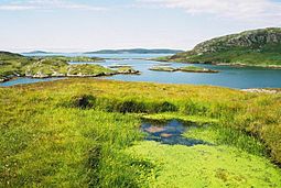
 The Sound of Gighay looking northwest from Càrais on Hellisay |
|
| OS grid reference | NF756040 |
| Coordinates | 57°01′N 7°21′W / 57.01°N 7.35°W |
| Physical geography | |
| Island group | Uists and Barra |
| Area | 142 hectares (0.55 sq mi) |
| Area rank | 127= |
| Highest elevation | Meall Meadhonach 79 metres (259 ft) |
| Administration | |
| Sovereign state | United Kingdom |
| Country | Scotland |
| Council area | Na h-Eileanan Siar |
| Demographics | |
| Population | 0 |
Hellisay (Scottish Gaelic: Theiliseigh) is a small, uninhabited island in Scotland. It is one of ten islands found in the Sound of Barra. This area is very important for nature conservation in the southern Outer Hebrides. A narrow channel, called the Sound of Gighay, separates Hellisay from its nearby island.
Island Features and Rocks
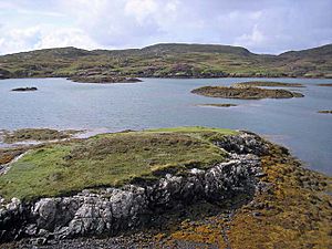
Hellisay is part of a group of islands in the Sound of Barra. This sound is a special area for protecting nature in the Outer Hebrides of Scotland. Hellisay is very close to its neighbor, Gighay, with the narrow Sound of Gighay between them.
The main rock found on Hellisay is called gneiss. You can also see shiny quartz veins running through it.
The island has several hills. These include Beinn a' Chàrnain in the west, which is about 73 meters (240 feet) high. Meall Meadhonach is the middle hill, standing at 79 meters (259 feet). Meall Mòr is another hill, about 76 meters (249 feet) tall, located east of Meall Meadhonach.
Animals and Plants
Hellisay is home to many different kinds of seabirds. You might also spot large raptors flying overhead. These include falcons and even golden eagles.
The island is covered in beautiful sea thrift flowers. The Sound of Gighay, the channel next to Hellisay, is known for its wild irises and marshmallows. It's described as a quiet and secret place.
Island History

The name Hellisay comes from the Old Norse language. It might mean "island of the caves." This idea is supported by a place on the east side of the island called Rubha na h-Uamh, which means "headland of the cave." However, an old map by Joan Blaeu shows the name "Hildesay," which could mean "Hilda's Island."
The main settlement on Hellisay was called Buaile Mhòr. This name means "the big fold." It was located near Eilean a' Ghamhna in the northwest part of the island. Today, you can still see the remains of a sheep pen and a well there.
Like many islands in this region, Hellisay was greatly affected by events known as the Highland Clearances. At first, people who had to leave their homes on other islands came to Hellisay. This made the population grow. Later, the people living on Hellisay themselves were asked to leave. Many of them moved to the nearby island of Eriskay. The population of Hellisay reached its highest point in 1841, with 108 people. Most people left in the 1840s, but some continued to live there until about 1890.
Stories collected by Alasdair Alpin MacGregor show that Hellisay had many interesting folk tales and myths. Only a small part of these stories has been saved.
Hellisay in Books
A Franciscan priest and author named Rayner Torrington wrote a book about his experiences. He was influenced by meeting a hermit named Peter Calvay. Peter Calvay lived on Hellisay for several years in the early 1900s. The book, called ‘Peter Calvay, hermit: A personal rediscovery of prayer,’ was first published in 1977. It has been printed many times since then. Torkington's later book, ‘Wisdom from the Western Isles: the making of a mystic’ (published in 2008), also talks about his meetings with Peter Calvay while he was staying on the nearby island of Barra.
 | Delilah Pierce |
 | Gordon Parks |
 | Augusta Savage |
 | Charles Ethan Porter |


