Hidalgo County, New Mexico facts for kids
Quick facts for kids
Hidalgo County
|
|
|---|---|

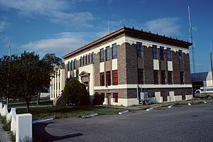
Hidalgo County courthouse in Lordsburg
|
|

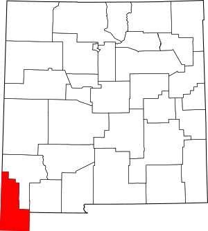
Location within the U.S. state of New Mexico
|
|
 New Mexico's location within the U.S. |
|
| Country | |
| State | |
| Founded | January 1, 1920 |
| Named for | Villa de Guadalupe Hidalgo |
| Seat | Lordsburg |
| Largest city | Lordsburg |
| Area | |
| • Total | 3,446 sq mi (8,930 km2) |
| • Land | 3,437 sq mi (8,900 km2) |
| • Water | 9.1 sq mi (24 km2) 0.3%% |
| Population
(2020)
|
|
| • Total | 4,178 |
| • Density | 1.2124/sq mi (0.46812/km2) |
| Time zone | UTC−7 (Mountain) |
| • Summer (DST) | UTC−6 (MDT) |
| Congressional district | 2nd |
Hidalgo County (which is Condado de Hidalgo in Spanish) is the county farthest south in the state of New Mexico. In 2020, about 4,178 people lived there. The main city and county seat is Lordsburg.
Hidalgo County was created from the southern part of Grant County. This happened on January 1, 1920. The county got its name from a town near Mexico City. This town was where the Treaty of Guadalupe Hidalgo was signed. The town itself was named after Miguel Hidalgo y Costilla. He was a priest known as the "Father of Mexican Independence."
This county is right on the border with Mexico. Most of the people living here are of Hispanic or Latino background.
Contents
Geography of Hidalgo County
Hidalgo County covers a total area of about 3,446 square miles. Most of this area, about 3,437 square miles, is land. Only a small part, about 9.1 square miles, is water.
The southern part of the county is often called the Bootheel. This area is bordered by Mexico to the east and south.
Neighboring Areas
Hidalgo County shares borders with other counties and areas:
- To the north: Grant County
- To the east: Luna County
- To the west: Cochise County, Arizona
- To the northwest: Greenlee County, Arizona
- To the south: Agua Prieta, Sonora, Mexico
- To the southeast: Ascensión, Chihuahua, Mexico
- To the south: Janos, Chihuahua, Mexico
Protected Natural Areas
Parts of two large national forests are found within Hidalgo County:
- Coronado National Forest
- Gila National Forest
Population and People
The number of people living in Hidalgo County has changed over the years.
| Historical population | |||
|---|---|---|---|
| Census | Pop. | %± | |
| 1920 | 4,338 | — | |
| 1930 | 5,023 | 15.8% | |
| 1940 | 4,821 | −4.0% | |
| 1950 | 5,095 | 5.7% | |
| 1960 | 4,961 | −2.6% | |
| 1970 | 4,734 | −4.6% | |
| 1980 | 6,049 | 27.8% | |
| 1990 | 5,958 | −1.5% | |
| 2000 | 5,932 | −0.4% | |
| 2010 | 4,894 | −17.5% | |
| 2020 | 4,178 | −14.6% | |
| U.S. Decennial Census 1790-1960 1900-1990 1990-2000 2010 |
|||
In 2010, there were 4,894 people living in the county. About 56.6% of the people were of Hispanic or Latino background. The largest ancestry group was Mexican, making up about 50.3% of the population. Other groups included German, English, and Irish.
The average age of people in the county was about 40.9 years old.
Towns and Villages
Hidalgo County has several communities, from cities to small villages and even ghost towns.
City
- Lordsburg (This is the county seat, meaning it's where the county government is located.)
Village
Census-Designated Places
These are areas that are like towns but are not officially incorporated as cities or villages.
Unincorporated Communities
These are small settlements that are not officially part of any city or village.
- Antelope Wells
- Garcia
- Mouser Place
- Road Forks
- Summit
Ghost Towns
These are places where people used to live, but now they are mostly empty.
- Bramlett
- Cloverdale
- Gary
- Road Fork
- Steins
- Shakespeare
- Valedon
See also
 In Spanish: Condado de Hidalgo (Nuevo México) para niños
 | Janet Taylor Pickett |
 | Synthia Saint James |
 | Howardena Pindell |
 | Faith Ringgold |

