History of local government in Wales facts for kids
The history of local government in Wales is all about how different parts of Wales have been managed over time. Think of local government as the people and groups who make decisions and provide services for your local area, like schools, roads, and libraries.
Modern local government in Wales really started in the late 1800s. In 1889, special areas called administrative counties and county boroughs were created. Later, in 1974, these were changed into a new system with eight larger counties, which were then split into thirty-seven smaller districts. This system didn't last too long! In 1996, Wales switched again to 22 single-tier authorities, which are still used today.
Contents
How Local Government Started in Wales (1888)
From 1889 until 1974, local government in Wales used areas called counties. These counties were set up by a law called the Local Government Act 1888. This law used the old, traditional areas of Wales as a guide, but the new administrative counties weren't exactly the same as the historic ones.
Administrative Counties: The First Big Areas
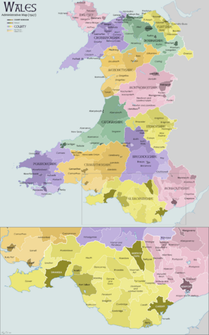
The table below shows how big these administrative counties were and how many people lived in them in 1891 and 1961. This helps us see how things changed over many years.
| Administrative county | Area in 1891 (acres) |
Population in 1891 | Area in 1961 (acres) |
Population in 1961 |
|---|---|---|---|---|
| Anglesey | 175,836 | 50,098 | 176,694 | 51,705 |
| Brecknockshire | 469,894 | 51,393 | 469,281 | 55,185 |
| Cardiganshire | 443,071 | 63,467 | 443,189 | 53,648 |
| Carmarthenshire | 587,816 | 130,566 | 588,271 | 168,008 |
| Caernarfonshire | 360,138 | 117,233 | 364,108 | 121,767 |
| Denbighshire | 424,235 | 118,843 | 427,978 | 174,151 |
| Flintshire | 164,051 | 77,277 | 163,707 | 150,082 |
| Glamorgan | 505,815 | 467,954 | 468,808 | 523,253 |
| Merionethshire | 427,810 | 49,212 | 422,372 | 38,310 |
| Monmouthshire | 342,548 | 203,347 | 346,779 | 336,556 |
| Montgomeryshire | 510,111 | 58,003 | 510,110 | 41,165 |
| Pembrokeshire | 392,710 | 88,296 | 393,008 | 94,124 |
| Radnorshire | 301,164 | 21,791 | 301,165 | 18,471 |
County Boroughs: Cities with More Control
Besides the administrative counties, there were also special areas called county boroughs. These were usually large towns or cities that had more control over their own local services, almost like mini-counties themselves.
The county boroughs created during this time were:
- Cardiff (started in 1889)
- Swansea (started in 1889)
- Newport (started in 1891)
- Merthyr Tydfil (started in 1908)
Here's how these county boroughs grew in size and population:
| County borough | Area in 1911 (acres) |
Population in 1911 | Area in 1961 (acres) |
Population in 1961 |
|---|---|---|---|---|
| Cardiff | 6,373 | 182,259 | 15,085 | 256,582 |
| Merthyr Tydfil | 17,761 | 80,990 | 17,760 | 59,039 |
| Newport | 4,504 | 83,691 | 7,691 | 112,298 |
| Swansea | 5,202 | 114,663 | 21,600 | 167,322 |
New System: Counties and Districts (1974)
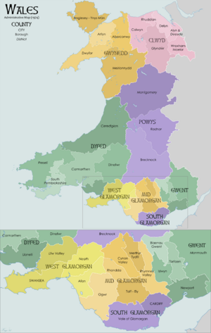
In 1974, the old administrative counties and county boroughs were completely changed. A new law, the Local Government Act 1972, created eight brand new areas, which were also called 'counties'. These new counties were then divided into smaller areas called districts. This meant Wales had a "two-tier" system of local government.
Most of these new counties were given names only in the Welsh language. However, the three counties in the Glamorgan area had both Welsh and English names. Even though these new areas were for managing local services, the old traditional counties of Wales were still remembered for other things, like for the Lord-Lieutenant (the King's representative in an area). These older areas are now known as the preserved counties of Wales.
The Eight New Counties
Here are the names of the eight new counties created in 1974:
- Gwent
- South Glamorgan (De Morgannwg)
- Mid Glamorgan (Morgannwg Ganol)
- West Glamorgan (Gorllewin Morgannwg)
- Dyfed
- Powys
- Gwynedd
- Clwyd
Districts: Smaller Local Areas
Each of these new counties was then divided into smaller districts. These districts were responsible for more local services within their county.
- Clwyd had these districts: Alyn and Deeside, Colwyn, Delyn, Glyndwr, Rhuddlan, Wrexham Maelor.
- Dyfed had these districts: Carmarthen, Ceredigion, Dinefwr, Llanelli, Preseli Pembrokeshire (called Preseli until 1987), South Pembrokeshire.
- Gwent had these districts: Blaenau Gwent, Islwyn, Monmouth, Newport, Torfaen.
- Gwynedd had these districts: Aberconwy, Arfon, Dwyfor, Meirionnydd, Anglesey.
- Mid Glamorgan had these districts: Cynon Valley, Ogwr, Merthyr Tydfil, Rhondda, Rhymney Valley, Taff–Ely.
- Powys had these districts: Brecknock, Montgomery, Radnor.
- South Glamorgan had these districts: Cardiff, Vale of Glamorgan.
- West Glamorgan had these districts: Lliw Valley, Neath, Port Talbot (called Afan until 1986), Swansea.
The Current System: Single Authorities (1996)
In 1996, Wales changed its local government system again. The two-tier system (counties and districts) was replaced by 22 single-tier authorities. This means each of these 22 areas is responsible for all local services, without being split into smaller districts.
Here's how the old districts were grouped together to form the current single authorities:
| Unitary authority | Previous districts |
|---|---|
| Blaenau Gwent | most of Blaenau Gwent |
| Bridgend | most of Ogwr |
| Caerphilly | Islwyn, Rhymney Valley |
| Carmarthenshire | Carmarthen, Llanelli, Dinefwr |
| Cardiff | Cardiff, part of Taff–Ely |
| Ceredigion | Ceredigion |
| Conwy | Aberconwy, most of Colwyn |
| Denbighshire | Rhuddlan, parts of Glyndwr and Colwyn |
| Flintshire | Alyn and Deeside, Delyn |
| Gwynedd | Arfon, Dwyfor, Meirionnydd |
| Isle of Anglesey | Anglesey |
| Merthyr Tydfil | Merthyr Tydfil |
| Monmouthshire | Monmouth, part of Blaenau Gwent |
| Neath Port Talbot | Neath, Port Talbot, parts of Lliw Valley |
| Newport | Newport |
| Pembrokeshire | Preseli Pembrokeshire, South Pembrokeshire |
| Powys | Montgomeryshire, Radnorshire, Brecknock, part of Glyndwr |
| Rhondda Cynon Taf | Rhondda, Cynon Valley, most of Taff-Ely |
| Swansea | Swansea, parts of Lliw Valley |
| Torfaen | Torfaen |
| Vale of Glamorgan | most of Vale of Glamorgan |
| Wrexham | most of Wrexham, parts of Glyndwr |
 | Lonnie Johnson |
 | Granville Woods |
 | Lewis Howard Latimer |
 | James West |


