Holderbank, Aargau facts for kids
Quick facts for kids
Holderbank
|
||
|---|---|---|
 |
||
|
||
| Country | Switzerland | |
| Canton | Aargau | |
| District | Lenzburg | |
| Area | ||
| • Total | 2.33 km2 (0.90 sq mi) | |
| Elevation | 365 m (1,198 ft) | |
| Population
(Dec 2020 )
|
||
| • Total | 1,408 | |
| • Density | 604.3/km2 (1,565/sq mi) | |
| Postal code |
5113
|
|
| Surrounded by | Lupfig, Möriken-Wildegg, Scherz, Schinznach-Bad, Schinznach-Dorf, Veltheim | |
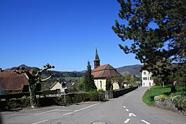
Holderbank is a small town, also called a municipality, located in the Lenzburg district. It is part of the canton of Aargau in Switzerland.
Contents
History of Holderbank
People have lived in the Holderbank area for a very long time! Archeologists have found items from the Neolithic (New Stone Age) and Bronze Age periods. They also found ruins and pottery from the Roman era and graves from the Alamanni people.
The name Holderbank first appeared in records in 1259. Back then, it was called in Halderwange. Later, around 1273, it was known as de Halderwanch. Some parts of the village used to belong to a place called Murbach Abbey. But in 1291, they sold their land to the Habsburgs, a powerful family. The Habsburgs then gave this land to their vassals, the von Wildegg family. The von Wildeggs also gained the right to make minor legal decisions in the village.
Church and Religion
The main church in Holderbank was first mentioned in 1275. It was the burial church for the Wildegg family. They also had the right to collect church taxes until 1805. After the Reformation, a big change in Christian religion, the nearby villages of Möriken and Wildegg joined Holderbank's church area in 1565. The church building you see today was built in 1701-02 by Samuel Jenner.
Village Life and Economy
Holderbank started out as a very small place. In 1559, there were only 10 houses, and in 1653, just 11. For a long time, people mainly made a living from farming. However, the Aare river often flooded and washed away their farmland. Until the 19th century, there were also vineyards in the village, growing grapes for wine. In the 1700s and 1800s, people also earned money by processing textiles (making cloth). From 1835 to about 1890, there was even a cotton printing factory.
Modern Development
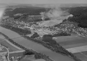
Big changes came to Holderbank in the 1800s and 1900s. In 1858, a railway line was built through the village. However, a train station wasn't added until much later, in 1999. In 1912, a factory that processed lime and a portland cement factory were built. An earthenware (pottery) factory started in 1933 and made products until the 1970s.
By 1950, most people in Holderbank worked in factories. But by 2000, about three-quarters of the workers were in the services sector, meaning they worked in jobs like retail, healthcare, or education.
Geography of Holderbank
Holderbank covers an area of about 2.32 square kilometers (0.90 square miles).
- About 19% of the land is used for farming.
- Around 36% is covered by forests.
- About 30% has buildings or roads.
- Rivers and lakes make up about 7% of the area.
- The remaining 7% is unproductive land, like rocky areas.
The town is located in the Lenzburg district. Holderbank is a linear village, which means its buildings are spread out along a road. It also includes a small settlement called Kernenberg, also known as Heilanstalt.
Holderbank's Coat of Arms
The blazon (official description) of Holderbank's coat of arms is: Gules an Elder-tree proper issuant from a circular Bench Argent. This means it shows a red background with a natural-colored elder tree growing from a silver circular bench. This design is an example of canting arms, where the picture on the shield hints at the name of the place. The elder tree (Holunder in German) and the bench (Bank in German) together sound like "Holderbank."
Population and People
As of the most recent information, Holderbank has a population of 1,408 people. About 24.5% of the people living here are from other countries. Most people in Holderbank (83.7%) speak German. Serbo-Croatian is the second most common language (5.1%), followed by Italian (5.0%).
Age Groups
Here's a look at the different age groups in Holderbank:
- Children (0-9 years old): 10.4%
- Teenagers (10-19 years old): 8.9%
- Young adults (20-29 years old): 11.7%
- Adults (30-39 years old): 14.1%
- Adults (40-49 years old): 17.1%
- Adults (50-59 years old): 17.0%
- Seniors (60-69 years old): 11.2%
- Seniors (70-79 years old): 5.7%
- Seniors (80-89 years old): 3.5%
- Seniors (90 and older): 0.3%
Homes and Households
In Holderbank, about 59.4% of homes are owned by the people living in them. This means they don't pay rent, though they might have a mortgage (a loan to buy the house). In 2000, there were 320 homes and apartments in the town, with an average of 2.4 people living in each. In 2008, 156 homes were single-family houses. There were also 8 empty apartments, meaning a 2.0% vacancy rate.
Political Choices
In the 2007 federal election, the most popular political party was the SVP, which received 58.4% of the votes. Other popular parties included the SP (11.2%), the FDP (10.4%), and the CVP (5.1%).
Population Over Time
Here's how Holderbank's population has changed over the years:
| Historical population | ||
|---|---|---|
| Year | Pop. | ±% |
| 1764 | 155 | — |
| 1850 | 281 | +81.3% |
| 1900 | 303 | +7.8% |
| 1950 | 622 | +105.3% |
| 2000 | 804 | +29.3% |
Economy and Jobs
In 2007, Holderbank had an unemployment rate of 3.38%, which means a small percentage of people looking for jobs couldn't find them.
Types of Jobs
- Primary sector: In 2005, 14 people worked in the primary sector, which includes jobs like farming and forestry. There were 3 businesses in this sector.
- Secondary sector: 72 people worked in the secondary sector, which involves manufacturing and construction. There were 12 businesses in this area.
- Tertiary sector: 602 people worked in the tertiary sector, which includes services like shops, offices, and healthcare. There were 28 businesses in this sector.
Many people who live in Holderbank travel to other towns for work. In 2000, about 78.8% of residents worked outside Holderbank. However, 473 people came into Holderbank for work. Most people (59%) used a private car to get to work, while 7.6% used public transportation.
Religion in Holderbank
According to the 2000 census, 28.7% of the people in Holderbank were Roman Catholic. Another 48.3% belonged to the Swiss Reformed Church, which is a Protestant church.
Transportation
Holderbank is located on the Baden–Aarau railway line. The town has its own train station, called Holderbank railway station, making it easy for people to travel by train.
Education
Switzerland is known for its good education system. In Holderbank, about 63.3% of adults (aged 25-64) have completed either high school or a higher education degree, like from a university. In the 2008/2009 school year, there were 49 students attending primary school in Holderbank.
See also
 In Spanish: Holderbank (Argovia) para niños
 | DeHart Hubbard |
 | Wilma Rudolph |
 | Jesse Owens |
 | Jackie Joyner-Kersee |
 | Major Taylor |


