Huai River facts for kids
Quick facts for kids Huai River |
|
|---|---|

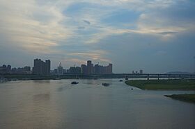
Huai River in the city of Bengbu, Anhui.
|
|

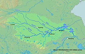
Map of the Huai River and its major tributaries.
|
|
| Other name(s) | Huai He |
| Country | China |
| Provinces | Henan, Anhui, Jiangsu |
| Cities | Xinyang, Fuyang, Lu'an, Huainan, Bengbu, Tianchang, Huai'an, Yangzhou |
| Physical characteristics | |
| Main source | Tongbai Mountain Nanyang, Henan 1,029 m (3,376 ft) 32°22′52″N 113°16′35″E / 32.3810°N 113.2763°E |
| River mouth | Yangtze Yangzhou, Jiangsu 0 m (0 ft) 32°18′28″N 119°42′13″E / 32.3078°N 119.7035°E |
| Length | 1,110 km (690 mi) |
| Basin features | |
| Progression | Yangtze → East China Sea |
| Basin size | 174,000 km2 (67,000 sq mi) |
The Huai River is a very important river in East China. It is about 1,110 kilometers (690 miles) long. Its drainage area, which is the land that collects water for the river, covers about 174,000 square kilometers (67,000 square miles).
The Huai River is located between China's two longest rivers: the Yellow River to the north and the Yangtze River to the south. In the past, the Huai River flowed directly into the Yellow Sea. However, over time, floods caused the river to change its path. Now, most of its water flows into the Yangtze River. The Huai River is known for often having floods.
The Huai River, along with the Qin Mountains, is sometimes seen as a natural dividing line in China. This line separates the northern and southern parts of the country. It roughly follows where the average January temperature is 0°C (32°F) and where about 800 millimeters (31 inches) of rain falls each year. This means the climate and even the culture can be quite different on either side of this line.
River's Journey
The Huai River starts in the Tongbai Mountain in Henan province. From there, it flows through the southern part of Henan. Then it moves into northern Anhui province and northern Jiangsu province. In Jiangsu, its waters gather in a large area called Lake Hongze.
Today, after Lake Hongze, the Huai River flows south. It becomes the Sanhe River and passes through Gaoyou Lake and Shaobo Lake. Finally, it empties into the Yangtze River near the city of Yangzhou.
There are also other paths for the Huai River's water. One is the North Jiangsu Main Irrigation Canal, which goes past Huai'an and reaches the sea at Biandan Port. Another path connects the Huai River to the Xinyi River, which flows into the sea near Lianyungang.
To help control floods, the Huai River system in Jiangsu province is connected to many other waterways. These connections are also part of the famous Grand Canal.
River's Past
Long ago, the Huai River used to flow directly into the Yellow Sea. It had a wide, flat path near the sea. People used its water to irrigate their farms, and there were many canals and smaller rivers connected to it.
| Huai River | |||||||||||||||
|---|---|---|---|---|---|---|---|---|---|---|---|---|---|---|---|
| Chinese | 淮河 | ||||||||||||||
| Hanyu Pinyin | Huái Hé | ||||||||||||||
| Postal | Hwai Ho | ||||||||||||||
|
|||||||||||||||
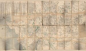
However, starting in 1194, the Yellow River to the north began to change its course. It repeatedly shifted south and flowed into the Huai River. This caused a lot of mud and silt to build up in the Huai River. Even after the Yellow River moved back to its northern path in 1897, the Huai River basin was greatly changed. New high areas and lakes formed, and the old path of the Yellow River was filled with silt.
Because of this, water from the middle part of the Huai River couldn't easily flow to the lower part. Also, the water in the lower part couldn't find a clear way to the sea. This problem became even worse during the Second World War. At that time, the Chinese government intentionally flooded the lower Huai basin. They did this to slow down the Japanese invasion. The main Yellow River flowed through this break for nine years, causing even more problems for the Huai River system.
All these changes meant that the Huai River's water often collected in Lake Hongze. Then, it flowed south towards the Yangtze River. Big and small floods happened very often. Between floods, the area would sometimes suffer from droughts. In the 450 years leading up to 1950, the Huai River experienced about 94 major floods every century.
To fix these problems, people have focused on building new ways for the Huai River's water to reach the Yangtze River and the sea. Today, most of the river's water goes into the Yangtze River through Lake Hongze. The North Jiangsu Main Irrigation Canal also carries some water along its old path to the sea. There are plans to make this canal even better with a new parallel channel. Some smaller rivers that used to be connected to the Huai River also help carry water to the sea.
River's Branches
The Huai River has many smaller rivers and streams that flow into it. These are called tributaries. There are 15 main tributaries that each cover an area larger than 2,000 square kilometers (770 square miles). Also, 21 main tributaries have a drainage area larger than 1,000 square kilometers (390 square miles).
Here are some of the main tributaries of the Huai River, listed from upstream (closer to the source) to downstream (closer to the mouth):
| North bank | South bank |
|---|---|
| Hong River | You River |
| Ying River | Shi River |
| Xi Fei River | Zhu Gan River |
| Guo River | Zhai River |
| Xin Bian River | Huang River |
| Kui Sui River | Bai Lu River |
| Shiguan River | |
| Pi He River | |
| Dong Fei River | |
| Chi River |
 | May Edward Chinn |
 | Rebecca Cole |
 | Alexa Canady |
 | Dorothy Lavinia Brown |


